Following the end of the War, Pres. Madison had cleverly decided to build upon the war-imposed sense of national unity and in his seventh Annual Message to Congress, dated December 5, 1815, he included an ambitious plan for “establishing throughout our country the roads and canals which can best be executed under the national authority.” It was the last five words of this sentence that revealed the subtle bone of contention of just what was the constitutional authority of the Federal government as it pertained to funding internal improvements? Following Jefferson’s precedent, Madison supported the Federal government’s involvement in funding internal improvements, if such authority could first be legally obtained by an amendment to the Constitution. In his push for internal improvements, Madison would be ably served by two Congressmen, John C. Calhoun from South Carolina and Henry Clay from Kentucky, who became the Speaker of the House on March 4, 1815, and who shared the President’s “nationalist” vision for the future on the young country.
In April 1816, Congress appropriated $100,000 for the resumed construction of the National Road that allowed it to be completed to Wheeling on August 1, 1818. Following the national election of 1816, the lame duck Congress during the winter of 1816-17, passed the Bonus Bill that called for the $1.5 million bonus that the Second Bank of the United States was to pay the Federal government for its initial charter, in addition to the annual dividends that the BUS was to pay the government, to be used to fund a national network of roads and canals. Calhoun, initially a staunch supporter of the Union, had proposed the bill: “We are under the most imperious obligations to counteract every tendency to disunion. Let us, then, bind the republic together with a perfect system of roads and canals. Let us conquer space.” Even though some from the East resisted the bill as its representatives saw little to be gained by encouraging the migration of their citizens to the West, and a few Southern slaveowners feared that “if Congress can make canals, they can with more propriety emancipate,” however, Calhoun and Clay, themselves slaveowners, saw the bill through to passage, only to have the President shock the bill’s supporters by vetoing it on March 3, 1817, the last day of his tenure, on the basis that the bill simply appropriated a large fund but did not specifically specify which projects it was to be used to fund, stating there was no constitutional authority for the Federal government to fund internal improvements. Madison had done so with the hope that an amendment would eventually be passed that would make such expenditures constitutionally legal in the future. As Pulitzer Prize winning historian Daniel Walker Howe stated, “Faced with a choice between theoretical consistency and practical politics, Madison chose theory… Madison [thereby] not only slowed the economic development of the country but, uncharacteristically, missed an opportunity to cement the Union together.”
The National Road, from Cumberland, MD (1811) to Vandalia, IL (1837). (Online)
Had Madison signed the bill into law, the National Road would, more than likely have been completed not only earlier, but also at least through to St. Louis, providing a route for commerce (and ideas) to flow back and forth along the geographic spine of the country between the three sections of the country, with St. Louis as its logical western terminal. (The Road’s construction would fitfully continue until the Panic of 1837 halted the Federal funding of its construction at Vandalia, IL, then the state capital, some 60 miles short of St. Louis.) Madison’s veto from a narrow, philosophic position not only had defeated Calhoun’s and Clay’s best efforts to more thoroughly unite the country along its middle, but also had set a legal precedent for those who wanted to further obstruct progress for any number of reasons. It would weigh heavily on the future of antebellum America, particularly that of the West, to the long-term detriment of St. Louis as no central highway from the Atlantic would crown it the capital of the West. Instead, Madison’s veto of 1817, some sixteen years before the chartering of the town of Chicago, would leave the door to the West sufficient ajar for the upstart city to eventually claim that crown.
Madison was succeeded by fellow Virginian James Monroe whose term was dubbed the “era of good feelings” as, for all practical purposes, Jefferson’s Democratic-Republican party had little, if any opposition as it had all but eliminated support for Hamilton’s Federalist party. Following the end of the War of 1812 that was perceived as a second American victory over Great Britain, Monroe had seized upon the nation’s sense of pride and began to propose a series of internal improvements that prior to the war would not have even been conceived by the party of Jefferson as it would have given too much power to the Federal government, thereby co-opting the Federalist’s agenda. In essence, Monroe’s proposals were verging on a “nationalist” agenda, not dissimilar to Hamilton’s original plans for the Federal government. Calhoun, whom Monroe had chosen as his Secretary of War and Speaker Clay would continue to support this nationalist agenda.
The Federal government wasted little time in sending Major Stephen H. Long on a survey expedition along the Chicago canal’s proposed route, reaching the mouth of the Chicago River in September, “where it discharged itself into the lake over a bar of sand and gravel, in a rippling stream, two to fifteen yards wide, and only a few inches deep.” The government had forced the Ottawa (that included the Potawatomis responsible for the Fort Dearborn massacre) and Chippewa tribes, who had sided with the British during the war, to sign the Treaty of St. Louis on August 24, 1816, in which they ceded a twenty-mile-wide strip of land from the mouth of the Chicago River southwest along the portage to Ottawa, within which was contained the proposed route of the canal. In his report, Long decried the danger to lake vessels due to the lack of any natural harbors along the southwestern portion of Lake Michigan and proposed the construction of two piers at the sandbar to facilitate the removal of the sand and to create a point of refuge for shipping by allowing deep draught vessels to enter the river. Those with foresight within the Federal government were, therefore, planning for the eventual construction of a canal from Lake Michigan to the Illinois River, even before construction of the Erie Canal had finally started in New York on July 4, 1817.
FURTHER READING:
Howe, Daniel Walker. What Hath God Wrought: The Transformation of America, 1815-1848. New York: Oxford University Press, 2007.
While the Treaty of Ghent ended the fighting between the U.S. and Great Britain, its terms, for all practical purposes, simply returned the situation of the two combatants to where it was before the start of hostilities. The same, however, could not be said of the situation for the Native Americans. The war had given Gen. Andrew Jackson the excuse he needed to begin the removal from the territory southwest of the Ohio River of the majority of its Native population, opening the region to Euro-American settlers. Meanwhile, in the NorthWest Territory, Natives who had fought alongside the British could no longer rely upon their protection. Madison’s Secretary of War William H. Crawford ordered that the army build a ring of forts from St. Louis around the Great Lakes to Detroit to discourage the British from continuing in the region’s fur trade, as well as to prevent their further contact with the local tribes. Those Natives who had managed to survive by playing one side against the other before the war, could no longer use the British as an effective counter to the growing number of American settlers.
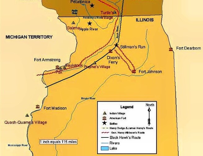
Map Showing Location of Fort Armstrong (Rock Island), Saukenuk, and Galena. Note the original Illinois border was to be south of Fort Dearborn. (Online)
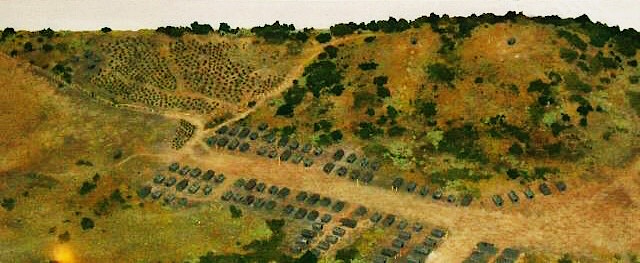
On May 10, 1816, American troops sailing up the Mississippi River arrived at Rock Island, the largest island along the Mississippi that was strategically important because it was located just upriver from the mouth of the Rock River, the major river system in northern Illinois and south central Wisconsin and commenced building Fort Armstrong on the island. Strategically, it was also located near the largest Native Sauk tribe village, Saukenuk, only four miles to south along the north bank of the Rock River. At this time, the village, with an estimated 4800 people, was the largest human settlement in Illinois.
Diorama of Saukenuk, John Hauberg Museum of Native American Life. (Online)
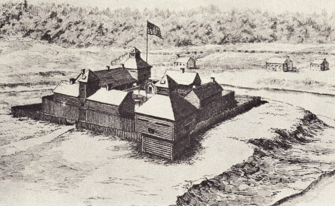
Some two months after the troops had arrived at Rock Island to build Fort Armstrong, American troops finally returned to the Chicago River to rebuild Fort Dearborn in July 1816, discovering the sun-bleached remains of the massacre’s victims. These forts were two in a line of seven new forts built by the U.S. to discourage not only any further British military incursions, but also any entry into the area by British and Canadian fur companies that had been banned from the fur trade in U.S. territory by Congress after the war. Astor had initially proposed this at the start of the war, and consequently had gained a monopoly over the region’s fur trade when his British partners in the South West Company were, therefore, forced to sell their interests to him. In the spring of 1817, Astor changed the company’s name back to its original, the American Fur Company. He then sent Ramsey Crooks to Mackinac as the company’s agent to restore the region’s fur trade that had languished during the war. Crooks, desiring to reestablish the American Fur Company’s intimate, but informal arrangements for the Fort Dearborn outpost’s fur trade, contacted John Kinzie at the Chicago River who had just returned to his home after having narrowly escaped the Fort Dearborn massacre. This relationship was further reinforced in the summer of 1818, when Kinzie took his oldest son, John H. Kinzie, to Mackinac to be indentured with the company for five years under Crook’s supervision.
Lt. William S. Evileth, the second Fort Dearborn, 1816. The first building in Chicago reputed to have been designed by an architect. (Andreas, History of Chicago-1)
Kinzie’s return to the Chicago River was apparently in response to the new and successful competition of John Crafts, an agent for the Detroit company of Conant & Mack, who had entered the Fort Dearborn market during the void caused by the war. Astor’s company responded in the fall of 1818 not only by moving its Milwaukee agent, Jean Baptiste Beaubien to Fort Dearborn to supplement Kinzie, but also by sending one hundred well-supplied men, known as the Illinois brigade, to combat Crafts’ success throughout Northern Illinois. Among these traders was sixteen-year-old Gurdon Saltonstall Hubbard, who became the most successful agent of the American Fur Company in the Illinois territory, traveling between Mackinac and Fort Dearborn each year, becoming “known to every man, woman, and child at the fort.” This was especially true with John Kinzie, at whose house Hubbard stayed while visiting the growing Fort Dearborn settlement, as well as with John H. Kinzie at Mackinac. Beaubien and Hubbard were so successful at cutting into Crafts’ market that Conant & Mack sold their operation to Astor in 1822, giving the American Fur Company a monopoly of the fur trade in Illinois.
1.8. THE GALENA LEAD RUSH
Fort Armstrong’s location had also interposed itself between Saukenuk and the rich lead deposits centered around the town of Galena that was only 90 miles north of the fort. Galena was then slated be in the southern portion of the future state of Wisconsin (the Northwest Ordinance had set the Illinois/Wisconsin border to be tangent with the southern tip of Lake Michigan) Following the erection of the fort, one of its garrison, Col. George Davenport, retired from the army later in 1816 and had shipped the first boatload of mined lead down the Mississippi to New Orleans. As lead was critical for military ammunition, the U.S. Department of War would eventually take control over the mines in 1822 and began to lease them to settlers, sparking the country’s first mineral rush. Regular Mississippi steamboat transit to Galena would begin in 1824 and by 1828, Galena would boast a population of over 10,000, the new residents having traveled either up the Mississippi or down the Rock or Wisconsin Rivers from the Great Lakes. Galena was then not only the largest city in Illinois (Illinois had been granted statehood in 1818), but it was also larger than St. Louis at this moment and became the major port in the upper Mississippi valley. In fact, the only city in the West larger than Galena during its “boom times” was Cincinnati whose population in 1830 of 24,831 made it the largest and most important city in the West, a position it would retain until the end of the Civil War.
FURTHER READING:
Andreas, Alfred T. History of Chicago, 3 vols. Chicago, 1884-1886. Reprint, New York: Arno Press, 1975.
Pierce, Bessie Louis. A History of Chicago– 3 volumes. New York: Knopf. 1940.
But events across the ocean were about to impact Jefferson’s rosy outlook as the Napoleonic Wars began to seriously impact American businesses. Following Adm. Nelson’s victory over the French at the Battle of Trafalgar on Oct. 21, 1805, both the British and the French had started to interfere with American shipping, even though the U.S. had steadfastly remained neutral. The British routinely stopped American ships on the pretext of searching for deserters, but with the actual goal of impressing them, and any men of questionable citizenship into the British navy. These actions had so enraged American public opinion that Jefferson was forced to respond. Not wanting to get into a shooting war, Jefferson, naively assuming that Europe needed American exports more than American business needed European markets, made the disastrous decision to outlaw all outbound shipping of American products by signing the Embargo Act on December 22, 1807. The results were predictable: American business interests were impacted the worst while the ban lasted for a devastating fourteen months, until Jefferson grudgingly bowed to the pressure of both the merchants and Congress by allowing Congress’ Non-intercourse Act of March 1809, that lifted the embargo on all countries except Great Britain and France, to become law on the last day of his administration. This bill still did little to improve the economy of the Atlantic seaboard and the return to business-as-usual was short-lived, however, for Britain renewed its onerous practice of impressing American sailors.
Not all the economic consequences of Jefferson’s embargo, however, had been negative. John Jacob Astor in New York City had been importing furs from Canada since 1794 from the North-West Company, a group of Scottish and French-Canadian fur merchants that had aligned to contest the chartered rights of the “English” Hudson Bay Company, that maintained exclusive British-sanctioned export rights. Astor, in essence, had established a dummy front for the North-West Company that also allowed the company to circumvent the British East India Company’s monopoly on the China trade, and in the process had become one of the city’s wealthier merchants by the time of the embargo. The embargo had also stopped all trade with Canada so Astor had to act quickly to protect his business. He approached Jefferson in 1808 and requested his permission to form a new company, the American Fur Company, with the expressed purpose of wrangling the control of the fur industry in all lands claimed by America out of the hands of both British companies and their agents. The idea was to build a chain of trading posts from St. Louis to the Oregon country (following the route of the Lewis and Clark expedition of 1803-6), to which Jefferson gave his tacit approval. In 1811, Astor was able to buy the British-owned Mackinac Company that he then reorganized into the new Anglo-American owned South-West Company, centered in St. Louis, that subsequently became the outlet for Kinzie’s furs from the Fort Dearborn outpost. Astor’s efforts to gain total control of the NorthWestern fur trade at this moment came to naught, however, when Democratic-Republican Pres. James Madison and Congress declared war against Great Britain on June 18, 1812, and British military power combined with their Native allies easily swept the Americans from the region.
Within a month, the British had captured the American Fort Michilimackinac on Mackinac Island at the juncture of Lakes Michigan and Huron, leaving Fort Dearborn as one of the more western and exposed outposts of the fledging Republic. The American commander of the West ordered the evacuation of the fort’s garrison to Fort Wayne, but as they began their retreat on August 15, a band of local Potawatomis sympathetic to the British massacred the garrison and a number of settlers, and then burned the fort to the ground. The stark isolation at this time of the Chicago River to the bulk of the U.S. population was made apparent by the fact that the victims’ remains were left exposed to the elements for the better part of four years until American troops returned to the ruins of the fort following the end of the war after Congress ratified the Treaty of Ghent in February 17, 1815.
FURTHER READING:
Andreas, Alfred T. History of Chicago, 3 vols. Chicago, 1884-1886. Reprint, New York: Arno Press, 1975.
Cincinnati’s rapid growth had pushed Ohio towards statehood that was granted in 1803. In anticipation of the state’s continued expansion, Congress had agreed the previous year to earmark some of the monies gained from the sale of public lands for the construction of a road to improve travel from the Atlantic coast into the trans-Appalachian interior. By the end of 1804 the Federal government had achieved its first budget surplus. President Jefferson in his second inaugural speech on March 4, 1805, was proud to make such an announcement and followed it up with the proposal that “the revenue thus liberated may be, by a just repartition of [the surplus] among the States… be applied in time of peace to rivers, canals, roads, arts, manufactures, education, and other great objects within each state.” Note that Jefferson, not in favor of a strong, Federal government, had proposed that the monies be spent not directly by the Federal government, but be directed to the states for their use. Nonetheless, a year later on March 29, 1806, he authorized the first Federal highway expenditure that was to fund improvements in the old Braddock Road that westward-bound travelers took from Cumberland, MD, at the headwaters of the Potomac River to Pittsburgh on the Ohio River. This would extend the route of two turnpikes, one from Baltimore and the other from Washington, DC, that had been constructed over time that would link Cumberland to the Atlantic. In addition, Jefferson proposed a new Cumberland Road (what eventually would become the National Road) that was to start at Cumberland but instead of leading to Pittsburgh, jogged westward at Uniontown, PA, toward Wheeling, VA, so as to reduce the travel time on the Ohio. From here it would run west to the state capitals of Columbus, Indianapolis, and Vandalia, thereby making travel between these cities easier. Construction did not start until 1811 and then had stalled due to lack of funding during the War of 1812. As its course roughly paralleled the Mason-Dixon Line, adjacent communities in both the North and the South could utilize the road, therefore, antebellum Sectional jealousies played no significant role in hampering the funding of this direct land route between the Atlantic coast and the nation’s central route of water transport.
The National Road, from Cumberland, MD (1811) to Vandalia, IL (1837). There was no “West Virginia” at this time. (Online)
These early routes to the Ohio River to the West were quite profitable for the Mid-Atlantic ports of Philadelphia (then the city with the largest economy, even though New York City’s population had surpassed it by 1790) and Baltimore as well as the newly established river ports of Cincinnati and Louisville, while the northern Atlantic ports in the Northeast, such as New York City and Boston, did not have water transportation into the trans-Appalachian hinterlands that proved to be a severe economic hindrance to the expansion of their business interests. True, New York enjoyed easy transportation along the Hudson River as far as Albany, but this route led north, and not west. Although the Great Lakes route represented a potential all-water passage between the Atlantic and the upper Mississippi valley (the NorthWest), it had two inherent problems. Goods had to be transferred overland around Niagara Falls, and the St. Lawrence River, the Great Lakes’ outlet to the Atlantic, was completely under British control. If these impediments could somehow be overcome, however, an all-water route from New York City to the Great Lakes could be forged, tapping the vast potential of the NorthWest by creating an alternative transportation route to the extant routes of the Ohio and Mississippi Rivers for the region’s products. Fortunately, due to a geologic quirk, the only break in the Appalachian chain between the Great Lakes and the Cumberland Gap in Tennessee was the valley of the Mohawk River that flowed west to east through central New York State and joined the Hudson River just above Albany. An all-water route to Lake Erie along the Mohawk Valley had first been proposed as early as November 1784 but had been endlessly debated over the next thirty-two years in the Byzantine corridors of New York State politics.
Route of the Erie Canal, 1825. Geneva, NY, the home of Charles Butler, is at the top of Seneca Lake. (Online)
The national economy had continued on its bright trajectory so that in his annual speech to Congress in 1807 Jefferson again recommended that the surplus be directed towards internal improvements. Not one to pass up a free dollar, the Senate on March 2, 1807, charged the Secretary of the Treasury, Albert Gallatin, to draw up a list of public improvements, especially roads and canals, towards which these funds could be directed. Gallatin returned in April 1808 with his report, whose centerpiece was the proposal of a $20 million, nationwide system of roads and canals, among which included a canal along the Mohawk River to Lake Erie in New York and a canal that would link the Chicago River with the Illinois River. The New York legislature responded in kind a month later by approving the funds to conduct a survey along the Mohawk Valley canal route to Lake Erie. In an attempt to transcend New York’s political infighting, a seven-member bipartisan canal commission with representation from all of the state’s regions in play was formed in 1810 to make a highly visible, comprehensive survey of the proposed canal’s prospects. Among its members were DeWitt Clinton, then the Democratic-Republican Mayor of New York City, Federalist Gouverneur Morris, the state’s beloved revolutionary statesman, and newly elected Democratic-Republican Congressman Peter Porter from Black Rock, located on the outskirts of Buffalo. In his inaugural speech in Congress, Porter had proposed the use of Federal funds to build the canal at the Chicago River as a link between the Great Lakes (Buffalo just happened to be within Porter’s district, where he and his brother operated a company that controlled the portage business around Niagara Falls) and the Mississippi, in order to form a continuous waterway from Lake Erie to the Gulf of Mexico.
Sometime in the early afternoon on August 17, 1803, Army Capt. John Whistler at the head of a garrison of troops that had been traveling from Detroit for the past thirty-five days, had finally come upon the mouth of the Chicago River, where he had been ordered to erect a fort to discourage further British military activity and to attempt to break the British control of the Native fur trade in the region. But with the British still present on the Great Lakes as well as in control of the mouth of the St. Lawrence River, and the Spanish controlling New Orleans and the lower Mississippi following the Treaty of Paris, there was no immediate need for the Americans to forge a link between the two water systems. The U.S. government had not shown any tangible interest in the Chicago River until 1803, when negotiations for the purchase of the Louisiana Territory and the corresponding control of the lower Mississippi, including the towns of New Orleans and St. Louis, had begun with French First Consul Napoléon Bonaparte, who had regained control over the territory from the Spanish in October 1800. Anticipating the successful outcome of these negotiations, President Jefferson had moved to consolidate the Federal government’s control along the upper Mississippi. On March 9, 1803, Secretary of War General Henry Dearborn had sent a letter to Col. Hamtramck, the commandant at Fort Detroit, ordering the survey of a land route from Detroit to the mouth of the Chicago River in the Indiana Territory (Chicago would be reallocated to the Territory of Illinois when Indiana was granted statehood in 1816) as well as of a site for the eventual erection of a fort. The Louisiana Purchase was formally signed in Paris on April 30, 1803, with Jefferson announcing it on July 4. Whistler had conducted the survey in May and June, and had the garrison assigned to the fort depart from Detroit on July 14.
The Mouth of the Chicago River, 1820. (Upper: Historic Maps and Views; Below: Andreas, History of Chicago-I)
Whistler found the river, roughly 90’ wide and 20’ deep to be stagnant, due to a sandbar that had been formed by the lake’s current at the mouth of the river, that itself had correspondingly moved over time (from its present location) to almost one half of a miles to the south before it ultimately flowed into the lake (some five blocks farther to the south, at the present location of Washington Street). Finding the area to be populated by only the buildings that du Sable had erected on the north bank, Whistler still chose to build the fort (appropriately named Fort Dearborn) on the south bank of the river at the bend in the mouth of the river that created a natural peninsula, utilizing the natural defense provided by the river to cover three of the fort’s four walls.
The first Fort Dearborn, 1803. In plan the fort consisted of a double stockade of logs, the space between was protected by two blockhouses at opposite corners of the square. (Upper: Kogan and Wendt, Chicago: A Pictorial History; Lower: Tallmadge, Architecture in Old Chicago)
This location (as opposed to the northern bank) also provided a secure land route around the lake’s basin for supplies and reinforcements from the Federal government’s forts in Indiana, Michigan and Ohio, as well as a direct land route to the southeast, avoiding any need to cross the river in an emergency retreat. The location of the fort would impose two long-range consequences on the development of the city of Chicago: first, the location of the fort would keep a large tract of prime lakefront property south of the mouth of the river out of the hands of private speculators and free of commercial buildings and industry for many years; and second, early settlement would concentrate around the fort for security, as well as for the advantage of the commercial potential of the fort’s garrison, establishing the dominance of the southside of the river as the city’s commercial center during the nineteenth century.
In the spring of 1804 John Kinzie, a Canadian fur trader originally from Quebec who had brought his family to the area in 1802, bought du Sable’s house. Kinzie was an employee of the British-owned Mackinac Company and had quickly established himself as the leading fur and Native trader in the area, founding a series of branch outposts from Milwaukee to the Illinois River. Employing Canadian voyaguers, these outposts all forwarded their furs to Kinzie’s house at the mouth of the river, from where they were shipped to Mackinac Island, the company’s home base.
John Kinzie’s House as it appeared in 1832. (Andreas-1, History of Chicago)
Meanwhile, the Governor of the District of Louisiana, William Henry Harrison, had taken advantage of four lonely (and reputedly drunk) Sauk Natives who had traveled to St. Louis, the District’s headquarters, to plead for the release of a tribal member accused of murder. Harrison offered them $2,234.50 and an annuity of $1,000 for signing a treaty on November 3, 1804, that relinquished all Native claims to some fifteen million acres east of the Mississippi lying between the Illinois and Wisconsin Rivers. The government graciously promised that all Natives could remain on the land for as long as it was owned by the Federal government, but this was quite ingenuous as the pattern had been since the founding of the Republic for the Federal government to sell all former Native lands to raise income for the fledgling nation.
1.4. JEFFERSON SENDS LEWIS AND CLARK TO THE PACIFIC
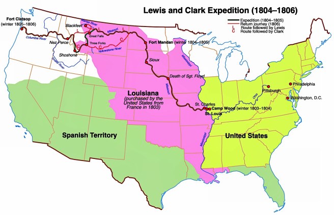
Meanwhile, during the final negotiations over the Louisiana Purchase, President Jefferson was planning an expedition led by Capt. Meriwether Lewis and Lt. William Clark to discover “the most direct and practicable water communication across this continent, for the purposes of commerce,” another attempt by Euro-Americans to discover the long sought-after Northwest Passage. As Spain controlled Alta California in the West that extended in places as far north as the 42° parallel (between the Oregon/California border), the expedition was prohibited from exploring a southern route through warmer climes. Meanwhile, the British controlled Canada, which meant that Lewis and Clark were limited to exploring a route through a relatively narrow geographic funnel between Spanish California and British Canada, in territory crossing the unexplored northern Rocky Mountains to the Pacific Northwest, whose jurisdiction was disputed by all three governments. (Therefore, the North had a debatable headstart, or to phase it from a different perspective, the South faced a major battle in gaining a physically contiguous route, in the coming battle over the route of the first transcontinental railroad.)
Route of Lewis and Clark Expedition, 1804-6. (Online)
The route of the expedition was to start at St. Louis, to be able to ascend the Missouri River to its headwaters and then to discover whether any of the known rivers in the Oregon country either joined it or were in its proximity, thereby posing a potential all-water route to the Pacific. Jefferson, however, was politically more concerned about having a better understanding of what type of land and natural resources were contained in the Louisiana Purchase, in addition to strengthening the U.S.’s claim on the Oregon country by hoping that Lewis and Clark would beat the British and the Spanish in making the first claim of discovery in this region. While Lewis continued to address matters back east, Clark proceeded to erect the Corps of Discovery’s base camp, Camp Dubois, on American territory on the east bank of the Mississippi, some 15 miles upriver from St. Louis, directly across from the mouth of the Missouri River, where they were forced to wait until Spain, who had continued to administer Louisiana, formally transferred it to American authorities whose arrival had been postponed by ice on the Mississippi. Finally, the Spanish transferred St. Louis to French officials on March 9, 1804, who, after flying the French flag for one day, then turned the city over to American officials on March 10. The Corps then crossed the Mississippi on May 14, 1804, and would not return to St. Louis until September 23, 1806, some two years and four months later, having successfully reached the Pacific Ocean at the mouth of the Columbia River (near today’s Astoria, OR). Unfortunately, they reported that they did not find an all-water route to the Pacific Ocean. Travel to the Pacific Coast from the United States (i.e., the Atlantic Coast), therefore, would involve either the long, three to six-month long sea voyage around Cape Horn, or the arduous and dangerous land route from St. Louis through the northern Rocky Mountains.
FURTHER READING:
Andreas, Alfred T. History of Chicago, 3 vols. Chicago, 1884-1886. Reprint, New York: Arno Press, 1975.
Harpster, Jack. A Biography of William B. Ogden. Carbondale: Southern Illinois University, 2009.
Tallmadge, Thomas Eddy. Architecture in Old Chicago, Chicago: University of Chicago Press, 1941.
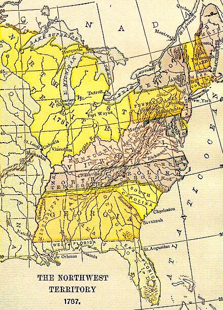
Map of the Northwest Territory, 1787. Note that the original border between Illinois and Wisconsin is mistakenly located at its final location. (Online)
Chicago’s Canadian citizenship was short-lived, however, for the area was successfully invaded early into the American Revolution during the summer of 1778 by Lt. Col. George Rogers Clark leading a force of Virginia militia and volunteers who had gathered near the Falls of the Ohio, that marked the founding of the city of Louisville, named in honor of the King of the revolution’s French allies, King Louis XVI, whose town charter was approved by Virginia two years later in 1780. Clark’s force first captured the British forces at Kaskaskia (on the Mississippi in southern Illinois south of St. Louis) and then at Vincennes (in southern Indiana on the east bank of the Wabash River). The war was formally ended with the signing of the Treaty of Paris on Sept. 3, 1783, with all British lands east of the Mississippi and south of the Great Lakes falling under the auspices of the U.S. Congress of the Confederation that faced the task of the disposition and governing of these “unorganized” lands and their current indigenous populations. On April 23, 1784, Congress adopted a Land Ordinance, drafted by a committee of five delegates led by Virginian Thomas Jefferson that stated that the existing thirteen states would not expand into the territory west of the Appalachians based on their prior claims to the same, but that these states would cede these lands to Congress from which ten new states would be formed that would enjoy the same rights and responsibilities that the original thirteen states then did. Hence, Virginia ceded its territory in Illinois to the Congress, that in the meantime had begun planning the future sale and settlement of the lands inhabited by Native American tribes that lay west of the Appalachian Mountains, north of the Ohio River, and east of the Mississippi River by passing the Land Ordinance of 1785 on May 20. The Congress had drafted the ordinance as an orderly process to sell this newly acquired land as a method to raise funds for the Federal government that at the time did not have the legal authority to raise revenues through taxation. The 1785 Ordinance specified a plan to systematically organize the land rationally with the use of a Cartesian or rectilinear grid. The use of the grid to layout European cities dated back to ancient Greece during the 5th century BC. A number of colonial cities in America had been laid out on a strict gridiron of streets, New Haven, CT (1638), Philadelphia (1682), and Savannah (1733) being probably the best examples, but the scale of this latest application of the grid to lend order to such a large land mass was unprecedented.
The Land Ordinance of 1785 and its system to survey land in the Northwest Territory. (Online)
This process for the organization of such a large land mass had originally been devised in 1764 by Thomas Hutchins, then a British captain in the Royal American Regiment, to establish an overall order to the land in northern Ohio surrendered by the French to the British following their defeat in 1763. At the time of the passage of the 1785 Ordinance, Hutchins was the Geographer of the U.S. and was tasked with the charge “to divide the said territory into townships six miles square, by lines running due north and south, and others crossing these at right angles… The plats of the townships, respectively, shall be marked into sections of one mile square, or 640 acres”. Therefore, unlike some American cities founded prior to 1785 such as Boston and New York (before 1811), whose street patterns reveal the influence of early human settlement and movement patterns as well as their response to local topographic features, Chicago’s future urban pattern of a rectilinear grid of streets (with the few exceptions of existing Native American paths) was influenced by Congress some forty-eight years before the town was first chartered.
On July 13, 1787, the Congress created the first Federal territory in the U.S., with the passage the Northwest Ordinance (so named in that it addressed the status of “Territory Northwest of the Ohio River”). While the 1785 Ordinance had specified the system of how the land in this region was to be surveyed for future sale, this new Ordinance established how it would ultimately be governed. Among its provisions, the legislation changed the number of potential states to be formed within the region from Jefferson’s original ten to be no fewer than three nor more than five. While the Confederation Congress was addressing the disposition of the new lands in the NorthWest, it was also busy attempting to reconfigure the entire national government that had been established by the 1781 Articles of Confederation, into a more effective political system. Two months after the Congress had approved the Northwest Ordinance, it signed the new U.S. Constitution, a fully debated compromise between the two major competing socioeconomic visions for the new country. While these visions were not completely segregated between those in the North and those in the South, the vision shared by a majority of Southerners, best represented in the ideals of Thomas Jefferson (who eventually formed the Republican Party, now referred historically to as the Democratic-Republican party to distinguish it from today’s Republican party), envisioned “Arcadia,” a country formed of independent idyllic farms run by gentlemen within a federation of states united by Federal national government with limited powers (that did not include the funding of internal improvements such as roads), while the northern vision may best be represented by the ideals of Alexander Hamilton (who was to found the Federalist Party), who championed “Enterprise,” a country founded on unbounded trade, industry, and progress, made such by a strong, central Federal government (that could help the nation’s development by funding such internal improvements). Almost all political issues to face the new country, from tariffs to internal improvements, would be debated through these two lenses. The settlement and development of the trans-Appalachian lands would not escape this debate.
Significantly, the Northwest Ordinance prohibited the extension of slavery into these future states (no such prohibition applied to the territory south of the Ohio), overcoming earlier Southern Congressional resistance, and thereby, established the Ohio River as the de facto boundary between the North and South from the western tip of the Mason-Dixon Line, at the southeastern corner of Pennsylvania, to the Mississippi River. The main north/south boundary that would divide the new territory into its future states was logically determined by simply extending a boundary from the southern tip of Lake Michigan to the east to Lake Erie and to the west to the Mississippi River. This meant that the mouth of the Chicago River was not part of what was originally slated to be the state of Illinois but was planned to be included in the state of Wisconsin. This seemed consistent with the initial settlement pattern of Illinois, for while the French and British fur traders had come to Illinois via the Great Lakes, with the British controlling the St. Lawrence River and maintaining a strong presence along the northern shore of the lakes, immigrants and supplies from the American East Coast at this time had primarily come via the Ohio River to the southern portion of the future state from one of three routes, as there were few openings in the Allegheny Mountains that, for all practical purposes, had walled off the Atlantic Coast from the western hinterlands.
Potomac River to its headwaters at Cumberland, and the trail to the Ohio River at Pittsburgh. The route of the Chesapeake & Ohio Canal, planned vs. built is also shown. (Online)
Settlers bound for the NorthWest who originated from as far north as downstate New York and as far south to northern Virginia could travel overland to either Pittsburgh or Wheeling (which is what the Treaty of Fort Stanwix in 1768 had attempted to stem, to little avail), where they would transfer to a vessel on the Ohio River, that flowed westward from its headwaters in the western foothills of the Allegheny Mountains, for their downriver destinations in the interior. However, they could also take the Potomac River in Virginia up to its headwaters at what is today Cumberland, MD, (not to be confused with the Cumberland Gap in Tennessee) and then set out overland along the old Braddock Road, the first trans-Appalachian route (that the British had cleared at the start of the French and Indian War in 1755 in order to capture Fort Duquesne (Pittsburgh) on the Ohio River), looking for one of the tributaries of the Monongahela River that would then take them to the Ohio River at Pittsburgh. Settlers from southern Virginia to Georgia, meanwhile, could take the route that Daniel Boone had blazed in 1775 through the Cumberland Gap into Kentucky and on to the Ohio River. Whichever route was chosen, the goal was to get to the Ohio River as easily as possible, that one could then float downriver to the new lands in the west.
Map of the eastern U.S., showing the Ohio River and Mississippi River routes into the NorthWest. The importance of the potential of an Erie Canal in linking New York, via the Hudson River, to the Great Lakes and that of a canal from Chicago to the Illinois River is evident. (Online)
The Ohio River, however, makes a sharp bend to the south some 100 miles upriver from Louisville that significantly increased the overland distance for those settlers destined for northern Indiana and Illinois. Just before the Ohio turns towards the south, the Licking River in Kentucky, almost as extensive of a waterway as the Kentucky River, empties into the Ohio. Across from the mouth of the Licking River, the Great and Little Miami Rivers with their combined watersheds reaching into the middle of Ohio, also empty into the Ohio River. It was here, then, that the settlement of Cincinnati was founded in 1788 (within a year of the passage of the Northwest Ordinance) as a departure port for lands in the NorthWest. With its shorter overland distance to the north as well as the combined inland watersheds of the Licking and Miami Rivers providing easy transport to inland markets, Cincinnati quickly surpassed Louisville that had no rivers into the interior, as the major port on the Ohio River.
Settlers moving into the Cincinnati region found it to be well suited for the growing of corn that could be easier transported to market if either distilled into whisky or fed to pigs. The pigs were easier to ship back east if processed into pork and lard. Cincinnati quickly became “Porkopolis,” the country’s largest pork-processing center. (Some of the lard in 1837 would be used by two brothers-in-law, William Proctor and James Gamble, to make industrial-processed soap, establishing one of the country’s largest and most stable companies.) Cincinnati’s location, at the midway point along the Ohio River, centered equally between and with easy river access to the newly-emerging markets in both the northern and southern states would allow it, although younger than St. Louis by some twenty-four years, to quickly surpass its western competitor in population and become the center of western business and migration from the antebellum Northern states, if for no other reason than St. Louis did not become part of the U.S. until the Louisiana Purchase was signed in 1803.
Although the British had ceded their claims to the NorthWest, no such arrangement had ever been agreed to by the Native tribes, who were reacting with increasing hostility to what they viewed as the illegal westward encroachment of the whites. It was not until the summer of 1794 that General “Mad Anthony” Wayne was able to subdue the tribes of the Western Confederacy at the Battle of Fallen Timbers (near today’s Toledo). Subsequently, Wayne forced an uneasy truce on the Natives with the signing of the Treaty of Greenville (Ohio) on August 3, 1795. Among its provisions, the Natives not only surrendered all claims to the lands in southern Ohio, but also agreed to cede to the U.S. “one piece of land six miles square, at the mouth of the Chicago River, emptying into the southwest end of Lake Michigan,” and to allow free passage “from the mouth of the Chicago River to the commencement of the portage between that river and the Illinois, and down the Illinois River to the Mississippi.” The young Federal government had its eyes on the Chicago region and the potential for a canal in this location for some thirty-five years before the town’s first Euro-American settlers had begun to displace its Native population.
FURTHER READING:
Andreas, Alfred T. History of Chicago, 3 vols. Chicago, 1884-1886. Reprint, New York: Arno Press, 1975.
Industrial Chicago-vol. 1: The Building Interests, Chicago: Goodspeed, 1891.
Lewis, Lloyd, and Smith, Henry Justin, Chicago: The History of Its Reputation, Rahway, N.J., 1929.
Pierce, Bessie Louis. A History of Chicago– 3 volumes. New York: Knopf, 1940.
CHAPTER 1. DREAMS OF A CANAL INSPIRE A CITY (1803-1830)
1.1. THE COLONIAL SETTLEMENT OF THE NORTHWEST
One fall day in 1673, Jesuit missionary Jacques Marquette and French Canadian voyaguer Louis Jolliet were paddling their canoe down what would they name the Chicago River when they caught their first glimpse of the river’s mouth into the vastness of Lake Michigan. If we look at the history of the Chicago region through an European lens and avoid the history of Native Americans, then Chicago began under the flag of the kingdom of France. Although Jacques Cartier had planted the first French flag at the mouth of the St. Lawrence River in 1543, claiming “New France” for his King, Francis I, the colony had only managed to marginally survive as a fur-trading enterprise along the river until King Louis XIV, who began to exert his royal authority following the death of his Chief Minister, Cardinal Mazarin in 1661, declared New France as a Royal Province in 1663 in an attempt to encourage its expansion into the Pais d’en Haut (“the upper country” to the west that included the Great Lakes) with the hope of finding the much sought-after Northwest passage to the Pacific Ocean and China. In 1668, a mission was founded at Sault Sainte Marie where Lake Superior flows into Lake Huron. Three years later in 1671 Jesuit missionary Father Jacques Marquette founded the Mission of St. Ignace on the north shore of the Straits of Mackinac that join Lake Michigan and Lake Huron, some forty miles south of Sault Sainte Marie. That same year Louis XIV had claimed formal possession of the entire Great Lakes region and the Mississippi Valley through the exploration of Daumont de St. Lusson, who made the formal claim at Sault Sainte Marie.
Route of Marquette and Jolliet, 1673. Note the error in this map: it shows them entering Lake Michigan at Kenosha, not at the mouth of the Chicago River. (Online)
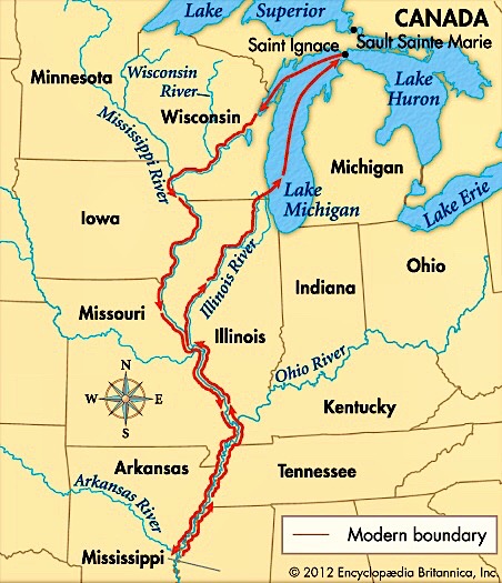
On May 17, 1673, Marquette, accompanied by voyaguer (a seasoned transporter of furs via canoe) Jolliet, set off from St. Ignace to explore the Mississippi Valley to determine whether it was the fabled Northwest passage. They took a route from Mackinac to the Mississippi, via the Wisconsin River, a route first traversed in 1634 by Jean Nicolet, another early voyaguer. They reached the Mississippi on June 17, 1673, and then traveled down the river for over a month until they reached the mouth of the Arkansas River. Here they learned from the local Native inhabitants not only that the river did not turn west to the Pacific, but also if they continued any farther south unfriendly Natives and Spanish soldiers (who had been exploring the lower Mississippi Valley for more than 130 years prior to the French expedition, starting with the Spanish explorer Hernando de Soto who in 1541 had first crossed the Mississippi River into northern Mississippi) could intercept them if they continued any farther. Therefore, Marquette and Jolliet reversed their course and headed back to Lake Michigan, returning in the fall of 1673. On their return they were directed by local Natives to take what is now the Illinois River back to Lake Michigan as a shorter route than from which they had started. After traversing up the Illinois River to its head at the confluence of the Des Plaines and Kankakee Rivers, they then followed the Des Plaines for some thirty-five miles, until they were led, via a short portage to a sluggish stream, the Chicago River that emptied into Lake Michigan.
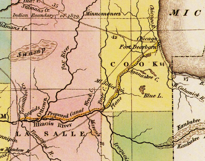
1833 Map by H.S. Tanner Showing the Route (dashed line) of the Canal. Note the portage between the Chicago River and the Des Plaines River, where Mud Lake has been drawn along the southern edge of the portage. The canal parallels but does not conjoin the Des Plaines River. It joins the Illinois River just below the “Rapids” at Starved Rock. (Ranney, Prairie Passage)
This allowed them to be the first documented Europeans to have set eyes upon the mouth of the Chicago River at Lake Michigan. The Native population had relied on this portage between the Des Plaines River, that flowed west to the Illinois River, and ultimately to the Mississippi River, and the Chicago River, which flowed east into Lake Michigan, for easy travel between the region’s two water systems. The portage, therefore, was an elevational plateau that divided the area’s drainage either west to the Mississippi River basin or east to the Great Lakes. During rainy periods, the portage itself often flooded, creating a “slough” or marsh that was called “Mud Lake” that made it possible to paddle between the two rivers.
Map of the eastern U.S., showing the Ohio River and Mississippi River routes into the NorthWest. The importance of the potential of an Erie Canal in linking New York, via the Hudson River, to the Great Lakes and that of a canal from Chicago to the Illinois River is evident. (Online)
The Chicago River, therefore, offered the potential to link the Great Lakes with the Mississippi River system with the construction of a relatively short canal between the Chicago and the Illinois Rivers. Although other sites on the western shore of Lake Michigan, such as the mouth of the Calumet River at the southern tip of Lake Michigan or the Milwaukee River at Milwaukee, WI, were found to have better harbors on Lake Michigan, Chicago’s only natural geographic feature – the close proximity of the Chicago River to the Illinois River – was sufficient argumentative evidence for the area’s supporter’s to successfully use against those who argued in favor of the other locations, in the coming debate for the Federal government’s support to build the canal that would make Chicago the lynchpin between two of the continent’s major antebellum water transportation networks: the Great Lakes via the Erie Canal, the industrial Northeast’s water route to the West, and the Mississippi River network, the lifeline of the antebellum agricultural South and upper Midwest. This potential had been acknowledged as early as 1673 by Jolliet who, following his return to St. Ignace, reported back to his King:
“We can quite easily go to Florida in boats, and by a very good navigation. There would be only one canal to make by cutting only half a league of prairie, [this was not an impossible task for the French at this time, as they were midway though the construction of the 150-mile long Canal du Midi, completed in 1681] to pass from the Lake of Illinois [Michigan] into the St. Louis River [the Des Plaines and Illinois]. The route to be taken is… Lake Erie to Lake Huron [to] the Lake of Illinois. At the extremity of this would be the cut, or canal,… to have a passage to the St. Louis River, which empties into the Mississippi… to the Gulf of Mexico… It would facilitate the communication from Quebec and Lake Erie… and but for a water-fall which separates Lake Erie from Lake Ontario, a bark… could go to Florida by the routes of which I have spoken.”
Although the mouth of the Chicago River would serve as nothing more than a settlement for itinerant French fur trapper/traders over the next century, Chicago’s European roots did reach back to Paris. In 1679, another early French explorer of the Chicago River, René Robert Cavalier, Sieur de la Salle, returned to the Illinois River, accompanied by the Jesuit priest Louis Hennepin. La Salle had first sent Hennepin to explore the upper Mississippi, who eventually reached the Falls of St. Anthony (that he recorded had a drop of over 50’), where Minneapolis was later settled. La Salle then set out in 1682 to explore the lower Mississippi. It took two months to reach the Gulf of Mexico on April 9, 1682, when he ignored the prior 140 year-old claims by the Spanish and claimed the entire river valley for his King and named it in his honor, “Louisiana,” that eventually evolved into two separate French administrative jurisdictions: Pais de Illinois (the Illinois Country), also referred to as la Haute-Louisiane (Upper Louisiana), comprised the land that lay north of the Arkansas River and was initially governed as part of the Province of Canada, and la Basse-Louisiane (Lower Louisiana) that extended south from the Arkansas River to the Gulf of Mexico.
Map of Pais des Ilinois, 1717. Note that “Chicagou” is located. (Bibliothèque Nationale, Cabinet des Estampes, Paris, France)
The portage at the Chicago River ultimately became a heavily traveled route that linked new settlements in Upper Louisiana back to their supply centers in Canada. Meanwhile, in 1712, Louis XIV had granted a 15-year trade monopoly in Louisiana that now included Upper Louisiana, to his banker and financial advisor Antoine Crozat, the wealthiest merchant in France, who began the serious settlement of Lower Louisiana. This arrangement lasted only for five years, however, for following the death of Louis XIV, his successor, Phillipe II, the Duke of Orléans, Regent for Louis’ five-year old great-grandson who eventually would be crowned King Louis XV, formally established the Province of Louisiana in 1717, with New Orleans (founded in 1718 and named after the Regent) eventually becoming its capital in 1722. This arrangement lasted only a few years before hostile members of the Fox tribe moved into the upper Mississippi valley. They were incensed that the French had armed their rivals, the Sioux, and consequently forced the French to abandon the Illinois-Chicago route in favor of the more eastern and safer Ohio-Wabash River route to Lake Erie.
Following the defeat of the French by the British in the French and Indian War in 1763, under the provisions of the Treaty of Paris that ended the war, France surrendered all of its land in North America north of the Ohio River and east of the Mississippi to Great Britain. The land that France had claimed west of the Mississippi, however, was ceded to Spain. Within a year of the French surrender French fur traders who operated within the confluence of the Mississippi and Missouri Rivers, from where they then traveled up the Missouri River expanding the ever westward search of the fur trade, had relocated from the eastern bank of the Mississippi, that was now under direct British control, and taken up residence on the western bank of the Mississippi in 1764 as France and Spain were Catholic allies, founding a trading settlement they called St. Louis, named in honor of Louis IX, the famous “St. Louis.”
Map of North America Boundaries after the Seven Years’ War. (Online)
From the British viewpoint, however, the land west of the Mississippi had always lain within Virginia’s original colonial borders that extended “westward to the sea.” To reassure the Natives who were still sympathetic to the French but who were now to trade with and be governed by the British Crown, King George III followed the Treaty of Paris with a Royal Proclamation in October 1763 that forbade any Colonial government to grant, or any white man to claim any land defined as “beyond the sources of rivers that flow into the Atlantic.” As the Ohio and Mississippi Rivers flowed west, away from the Atlantic seaboard, this watershed was now officially off-limits to colonial speculators. The prohibition was reaffirmed in the Treaty of Fort Stanwix, signed with the Iroquois in 1768 that legally stymied the development plans of such famous colonial land speculators as George Washington and Benjamin Franklin. Following the Boston Tea Party of Dec. 16, 1773, Parliament attempted to strengthen the ban on trans-Appalachian settlement by passing the Quebec Act on June 22, 1774, one provision of which pushed the border of British Quebec south to the Ohio River. The mouth of the Chicago River, therefore, was then under the direct legal jurisdiction of Canada.
This prohibition had done little, however, to stem the growing tide of Euro-American settlers moving across the Appalachians and into the fertile lands of Kentucky. The first few Kentucky settlers had traveled down the Ohio, but in 1775 frontiersman Daniel Boone had managed to cut a route from Washington County in the southwestern tip of Virginia through the Appalachians at the Cumberland Gap where Virginia, Tennessee, and Kentucky all come together, known as the Wilderness Road. Boone eventually reached the Kentucky River at a point where he established the settlement of Boonesborough, KY, roughly 75 miles southeast of the Ohio River. From Boonesborough settlers could then take the Kentucky River to where it emptied into the Ohio River, some 50 miles upriver from the Falls on the Ohio (Louisville), the only impediment to navigation along the entire length of the river that forced travelers to portage around them.
Map of Daniel Boone’s Trail to the Ohio River. (Online)
Meanwhile, the mouth of the Chicago River continued to remain unsettled with the only exception of the resident Native Americans and the few itinerant fur traders who continued to traverse the river. Jean Baptiste du Sable, a trader who dealt in furs and supplies, is the consensus among historians as the first non-Native “permanent resident” of the area. As he was not French, but the son of a Frenchman and a free black woman in Haiti, the Fox had allowed him and his wife to work his way up the Mississippi from New Orleans eventually settling in the Peoria region. He had expanded his operation to the mouth of the Chicago River in 1772 by constructing a trading post/log cabin on the north bank of the mouth of the river, to which he had moved with his family in 1774. Over the coming years, he expanded the outpost to a compound of nine buildings along the north bank of the mouth of the river that included his house (at what would be N. Water and Rush Streets), stables, a bakehouse, and a variety of farm buildings that stretched from the lake to what is now State Street and from the river to Grand Avenue.
Mouth of the Chicago River with Jean Baptiste du Sable’s house at the right, 1774. (Mayer and Wade)
FURTHER READING::
Andreas, Alfred T. History of Chicago, 3 vols. Chicago, 1884-1886. Reprint, New York: Arno Press, 1975.
Pierce, Bessie Louis. A History of Chicago– 3 volumes. New York: Knopf. 1940.
Wille, Lois. Forever Open, Clear, and Free; The Struggle For Chicago’s Lakefront. Chicago: Regnery, 1972.
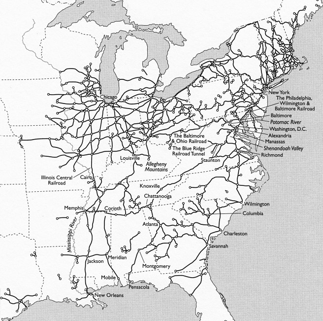
What I have attempted in this blog is to set the history of Chicago and its architecture of this period within its historical context. To truly understand and appreciate what an architect was trying to do in the design of a building, it is essential to know the surrounding physical context of the building’s site: which direction is south, what types of streets border it, and what existing buildings are immediate adjacent to it. A building’s “context,” however, is broader than just its site, as it includes the efforts of all of the people involved and the corresponding forces, decisions, and pressures addressed, and many times overcome, in the creation of the building. In the previous three paragraphs I purposefully referenced some of the leading European architectural theorists of the era without introducing them. These were the leading writers of modern architectural theory at the time, whose books were read, studied, and discussed by architects in Europe and the U.S., including Chicago. Chicago was not an island onto itself, isolated at the edge of civilization from any influence from developments or buildings in other cities or countries: it was intimately linked to the rest of the country by the telegraph and railroad. Within the short span of twenty-three years after its founding in 1833, Chicago had gone from being on the fringe of civilization, to being the center of American Midwestern civilization in 1856 as it became the hub of the largest network of tracks in the world.
Map of American Railroads and major junctions in 1861. (Thomas, The Iron Way)
The development of a city is no different from that of its architecture. Chicago did not grow in a vacuum; it was impacted by seemingly unrelated events that sometimes took place in remote locations. This was the context in which Chicago and its architecture evolved, and therefore, to get a clear and thorough understanding of the development of the city, including its architecture, one should examine the context in all its relevant aspects in which these events unfolded. For me, context is everything. In my forty-plus years of teaching architectural history at the University of Cincinnati to majors and non-majors alike, I found that not only introducing students to the topic, but also by placing the topic within its context, be that the historical, economic, social, political, geographic, or artistic context, at the regional, national, or international scale, gave a student a fuller understanding and appreciation for the topic. This is what I have attempted to do in this blog. I also recognize that a large portion of my audience is not intimate with many of the details of history that I need to refer to in telling this story. Therefore, I found it important to include sections that included events, people, and buildings from cities beyond Chicago and to summarize topics beyond those that directly relate to Chicago that I believe a reader needs to know in order to better comprehend a particular topic’s context. For those who already know the history of any of these topics that I have included, such as Napoleon III’s urban renewal of Paris or the British Design Reform movement, they can simply skip over the posts so dedicated if one wishes. But those who are not familiar with such topics will find their understanding of the topic to be richer for having been introduced to the contextual information.
Gustave Caillebotte, Paris Street; Rainy Day, 1877. A view of the reconstructed Paris accomplished by Napoléon III and Haussmann. (Art Institute of Chicago)
The four most important cities that played pivotal roles in Chicago’s historical, urban, and architectural development, that one cannot ignore if one wants to truly understand the Chicago phenomenon were Paris, London, Cincinnati, and New York. During the Second Empire of Napoléon III, Paris, la ville lumiére, had become the most important city in the world for both its architecture and its urban design, as the Emperor had embarked upon a twenty-plus year campaign to bring his capital into the technological nineteenth century. No less than French novelist, Victor Hugo, no fan of the Emperor by the way, sang the city’s praise best:
“It is in Paris that the beating of Europe’s heart is felt. Paris is the city of cities. Paris is the city of men. There has been an Athens, there has been a Rome, and there is a Paris…”
Napoléon III’s Paris was the model city for almost everyone who wanted to build a beautiful city in the later half of the nineteenth century. As we will see, there was a curious parallel in the chronology of events between the rise of the Second Empire of Napoléon III and the rise of Chicago (let’s not forget that the first European explorers of the Chicago area who laid claim to the region were French), starting with the timing of Louis Napoléon’s rise in French politics during the summer and fall of 1848, when he won the highest number of the votes cast for the National Assembly on September 17-8, that led to his victory in the Presidential election some three months later on December 10-11. As Louis Napoléon had spent the summer of 1848 laying the foundation for his eventual political success, William Ogden had spent that same summer laying the first tracks for the Galena & Chicago Union railroad (that would ultimately bring the transcontinental railroad to Chicago), with its first official run of eight miles having taken place on Nov. 20, only twenty days before Louis Napoléon was elected President. Meanwhile, at the end of this blog’s timeframe, one cannot fully comprehend the fear personally felt by Chicago’s “leading citizens” following the city’s destruction by the 1871 fire without understanding that some of Paris’ most important buildings had been destroyed only four and a half months earlier by fires purposefully set by members of the Parisian Commune (Communards) and that over 20,000 Parisians had been killed, as the army of the Nationalist government crushed their three-month long revolt and regained control of the city during the week of May 21-28, 1871.
Charles Barry and Augustus Pugin, House of Parliament, London, 1835.
(Online)
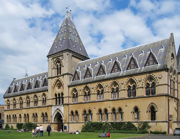
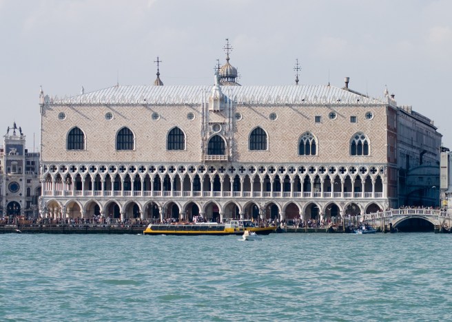
London at this time offered an artistic alternative in European design theory to that of Paris. So much so, in fact, that it will become quite evident to the reader that American architecture will be pulled between these two primary European poles of design theory during the second half of the nineteenth century. The battle within American architecture during this era was waged between those who championed the academic Neo-Baroque eclectic architecture of the Second Empire, and the few, but growing number of individuals who were influenced by the rising tide of innovative design initiated by the British writers Jones, Pugin, and Ruskin. It was of no little consequence that the most important buildings under construction in Europe between 1848 and 1871 that were most emulated by American architects were the Tuileries/Louvre complex and the Opera House in Paris, the Oxford Museum and the Midland Hotel/St. Pancras Station in London, and, of course, the Doge’s Palace in Venice that Ruskin had posited as “the central building of the world.”
Left: Philibert de l’Orme, et al., The Tuileries Palace, Paris, 1564-1865; Right; Charles Garnier, Paris Opera House, 1861. (Online)Left: Deane & Woodward, Oxford University Museum of Natural History, Oxford, 1855; George Gilbert Scott, Midland Hotel, London, 1865. (Online)Doge’s Palace, Venice, 1340-1442. (Online)
When Chicago was chartered as a town on Aug. 5, 1833, it had little in the way of indigenous cultural traditions and institutions, including architecture. When it was eventually ready to invest in these, Chicago naturally looked eastward for inspiration and precedents. The closest competition that Chicago had to overcome was that of Cincinnati, the “Queen City of the West.” Having had a forty-five year head start, Cincinnati had already moved beyond mere survival and into the cultural phase of urban development before Chicago had even been chartered as a city in 1837. As the two cities were basically in the same geographic region, it was Cincinnati, and not New York City, as is so often presumed to have been the case, that provided Chicago with models for it to first emulate when it was finally interested and financially able, and then to surpass those of its older and more established Midwestern competitor. But once Chicago had equaled Cincinnati, it then set its sights on New York City, the most important American city in regard to mid-century architecture. As New York was the largest city by population and economic importance in the U.S., it simply follows that New York’s architecture (especially that designed by George Post), modeled often, but not solely after Paris and London, would play a leading role within the country, even in Chicago.
Left: George B. Post, Mills Building, New York, 1881. (Online); Right: Burnham & Root, Rialto Building, Chicago, facing Van Buren, 1883. (Hoffmann, Root)Left: George B. Post, Produce Exchange, New York, 1880. (Online); Right: Adler & Sullivan (with William Ware), Design for the Auditorium, April 1887. (Siry, The Auditorium)
i.8. SUMMARY
I have chronologically organized this study into five parts:
1. the period from the first French claim on “Louisiana” that included the Chicago River in 1671 to the completion of the Illinois & Michigan Canal in 1848;
2. the period from when William Ogden began construction of the Galena & Chicago Union Railroad in 1848 to the financial panic of 1857, during which time Chicago became the hub of the world’s largest railroad network;
3. the period that included the build-up to the American Civil War and the war that discusses its impact on Chicago;
4. the immediate post-war period up to the fire of October 8, 1871, in which occurred the construction of the first transcontinental railroad when Chicago, correspondingly became the largest and central city of the West, and;
5. the post-fire reconstruction between the 1871 fire and the July 14, 1874 fire, the result of which was the cancellation of all fire insurance policies by Nov 1, 1874, that finally instigated the eventual improvement of Chicago’s construction practices that occurred during the Chicago School of the 1880s.
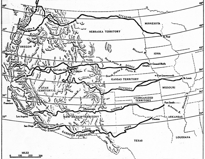
Surveyed Routes for the Transcontinental Railroad. In March 1853, Congress appropriated $150,000 to survey four possible routes. Those are shown with the names of the surveyor in charge. The actual route used with the Act of 1862, however, started from Council Bluffs/Omaha and was surveyed by Grenville Dodge. It was not even considered in the 1853 survey, but is included on this map. (Time-Life, Old West Railroads)
The recession of 1837-45 had slowed the construction of the Illinois & Michigan canal as well as economic migration in the West that allowed Cincinnati to maintain its central position as the largest city in the NorthWest. St. Louis, however, due to its natural geographic advantages was destined to eventually overtake Cincinnati as the country continued to grow ever westward, and it finally celebrated, along with Chicago, the completion of the canal in 1848. It was at this precise moment, however, that the technology of the nineteenth century had coalesced to produce the railroad that gave humans the power to overcome the nature-made advantages as well as the limits of geography. Therefore, the western city that would win this new competition set into motion by the introduction of the railroad into the American landscape, would dictate the resulting growth in the region. The most important political decision that would determine which western city would come out of top was where would the first transcontinental railroad be located, for over this route would eventually flow the vast majority of goods and people between the Atlantic and Pacific Oceans. In essence, the winner would become the capital of the interior of the United States, that is, the political, economic, and cultural center between the Atlantic and Pacific coasts.
The antebellum transcontinental railroad could have, and probably should have been built, for any number of reasons on a route that paralleled the Mason-Dixon Line from Baltimore to Cincinnati to St. Louis and westward (a second “Missouri Compromise,” if you will), that would have assured St. Louis’s future as the capital of the West. The smaller cities of Chicago in the north and Memphis in the south would eventually have been connected via branch lines to this trunk line. But antebellum Sectional jealousies in Congress as well as Luddite-like responses by some to the threat posed by this new-fangled technology to existing investments and businesses, especially those of the river steamboat industry, protracted the Federal decision on the transcontinental railroad for over two decades, until the start of the Civil War removed Southern obstructionists from the decision process while imposing a crisis upon the Northern Congress that forced it to finally make a decision. A decision that was not to the advantage of Cincinnati and St. Louis, for the competition would eventually be won by Chicago, not through any preordained geographic advantage, but through the hard-fought efforts of its citizens and those who had financial investments in the outcome of the competition, and with a little help from history. Hindsight reveals that every antebellum setback to the start of the construction of a compromise transcontinental route through the country’s midsection (i.e., Washington, D.C., Cincinnati, and St. Louis) prior to 1856 (the completion of the Illinois Central) was another victory for Chicago in its campaign to eventually become the dominant city in the West. To the credit of Chicago’s leading patrician, William Ogden, and Illinois’ Senator Stephen A. Douglas, the actual route of the first transcontinental railroad would eventually be located some 200 miles north of St. Louis to Chicago, making Chicago, and not St. Louis, the eventual nexus of the West’s water and railroad systems. (One could say that Congress’ decision actually reversed the “strategic” flow of the Chicago River some six years before the city reversed its actually flow.)
Map of Ogden’s consolidated routes of the new Chicago & Northwestern Railroad, 1864. At the time, it was the longest rail system in the country. (Harpster, Ogden)
For it was in 1848, the same year in which the canal was completed, that Ogden started construction of Chicago’s first railroad, the Galena & Chicago Union, headed not to the east to link up with the routes being built to the West but to the west to his ultimate objective, the Pacific Ocean. (I believe that historians have underestimated the importance of Ogden’s unilateral decision:: there were no railroads to Chicago in 1848, period. Ogden started his without any assurances that an Eastern railroad would build to Chicago.) He had gambled that the eastern railroads would want to lay tracks north to Chicago once they reached the southern tip of Lake Michigan to connect with his track, rather than simply laying tracks from the mouth of the Calumet River, some thirty miles to the south of the village of Chicago, west straight to Rock Island on the Mississippi. It would be more than three long years after Ogden had started laying tracks, however, before the first railroad from the Atlantic coast finally made a connection to Chicago in late 1851. But once Chicago was connected to the East coast, it then took only five more years to lay the world’s largest railroad network with Chicago as its hub, with some 58 passenger trains and 38 freight trains arriving/departing daily in 1856 along a network with over 3000 miles of track. Chicago’s population had expanded to 86,000 by this date, making it the fourth largest city west of the Allegheny Mountains (then New Orleans was still the largest with 140,000, Cincinnati was second with 135,000 and St. Louis was third with 90,000). All three Northern cities continued to gain in population during the Civil War, but after Congress finally decided in 1862 that the Union Pacific should start in Omaha, NE, in a direct line with Chicago, Chicago’s population grew the fastest, finally surpassing Cincinnati’s in 1868. Meanwhile St. Louis had already surpassed Cincinnati during the war to become the largest city in the West, a title it held until Chicago’s population finally surpassed St. Louis’, but this didn’t occur until after the transcontinental railroad was completed in 1869 and was in operation for a number of years.
Map of American Railroads and major junctions in 1861. (Thomas, The Iron Way)
Railroad construction in Chicago from its inception in 1848 to the 1871 fire was primarily financed not by Chicago capital (there was precious little of that during the city’s infancy), but first by East Coast and European venture capital and then with the infusion of Federal funding through landgrants such as that secured by Sen. Douglas’ tireless campaign to build the Illinois Central Railroad. Railroads not only directly affected the physical structure of the city, especially in regard to the location of the required stations, but also indirectly influenced how the city grew, as developers sought to erect their buildings within the close physical proximity to these new urban activity centers. Therefore, in order to truly understand and appreciate the accomplishment of the construction of Chicago’s rail network that would lead to its premiere position in the West, as well as the railroads’ impact on the physical development of the city’s business district, one needs to understand who was actually funding the construction of the railroads, as well as why and where these businessmen were building their lines and stations.