

Sometime in the early afternoon on August 17, 1803, Army Capt. John Whistler at the head of a garrison of troops that had been traveling from Detroit for the past thirty-five days, had finally come upon the mouth of the Chicago River, where he had been ordered to erect a fort to discourage further British military activity and to attempt to break the British control of the Native fur trade in the region. But with the British still present on the Great Lakes as well as in control of the mouth of the St. Lawrence River, and the Spanish controlling New Orleans and the lower Mississippi following the Treaty of Paris, there was no immediate need for the Americans to forge a link between the two water systems. The U.S. government had not shown any tangible interest in the Chicago River until 1803, when negotiations for the purchase of the Louisiana Territory and the corresponding control of the lower Mississippi, including the towns of New Orleans and St. Louis, had begun with French First Consul Napoléon Bonaparte, who had regained control over the territory from the Spanish in October 1800. Anticipating the successful outcome of these negotiations, President Jefferson had moved to consolidate the Federal government’s control along the upper Mississippi. On March 9, 1803, Secretary of War General Henry Dearborn had sent a letter to Col. Hamtramck, the commandant at Fort Detroit, ordering the survey of a land route from Detroit to the mouth of the Chicago River in the Indiana Territory (Chicago would be reallocated to the Territory of Illinois when Indiana was granted statehood in 1816) as well as of a site for the eventual erection of a fort. The Louisiana Purchase was formally signed in Paris on April 30, 1803, with Jefferson announcing it on July 4. Whistler had conducted the survey in May and June, and had the garrison assigned to the fort depart from Detroit on July 14.


Whistler found the river, roughly 90’ wide and 20’ deep to be stagnant, due to a sandbar that had been formed by the lake’s current at the mouth of the river, that itself had correspondingly moved over time (from its present location) to almost one half of a miles to the south before it ultimately flowed into the lake (some five blocks farther to the south, at the present location of Washington Street). Finding the area to be populated by only the buildings that du Sable had erected on the north bank, Whistler still chose to build the fort (appropriately named Fort Dearborn) on the south bank of the river at the bend in the mouth of the river that created a natural peninsula, utilizing the natural defense provided by the river to cover three of the fort’s four walls.
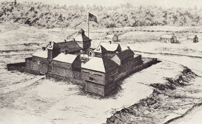

This location (as opposed to the northern bank) also provided a secure land route around the lake’s basin for supplies and reinforcements from the Federal government’s forts in Indiana, Michigan and Ohio, as well as a direct land route to the southeast, avoiding any need to cross the river in an emergency retreat. The location of the fort would impose two long-range consequences on the development of the city of Chicago: first, the location of the fort would keep a large tract of prime lakefront property south of the mouth of the river out of the hands of private speculators and free of commercial buildings and industry for many years; and second, early settlement would concentrate around the fort for security, as well as for the advantage of the commercial potential of the fort’s garrison, establishing the dominance of the southside of the river as the city’s commercial center during the nineteenth century.
In the spring of 1804 John Kinzie, a Canadian fur trader originally from Quebec who had brought his family to the area in 1802, bought du Sable’s house. Kinzie was an employee of the British-owned Mackinac Company and had quickly established himself as the leading fur and Native trader in the area, founding a series of branch outposts from Milwaukee to the Illinois River. Employing Canadian voyaguers, these outposts all forwarded their furs to Kinzie’s house at the mouth of the river, from where they were shipped to Mackinac Island, the company’s home base.

Meanwhile, the Governor of the District of Louisiana, William Henry Harrison, had taken advantage of four lonely (and reputedly drunk) Sauk Natives who had traveled to St. Louis, the District’s headquarters, to plead for the release of a tribal member accused of murder. Harrison offered them $2,234.50 and an annuity of $1,000 for signing a treaty on November 3, 1804, that relinquished all Native claims to some fifteen million acres east of the Mississippi lying between the Illinois and Wisconsin Rivers. The government graciously promised that all Natives could remain on the land for as long as it was owned by the Federal government, but this was quite ingenuous as the pattern had been since the founding of the Republic for the Federal government to sell all former Native lands to raise income for the fledgling nation.
1.4. JEFFERSON SENDS LEWIS AND CLARK TO THE PACIFIC
Meanwhile, during the final negotiations over the Louisiana Purchase, President Jefferson was planning an expedition led by Capt. Meriwether Lewis and Lt. William Clark to discover “the most direct and practicable water communication across this continent, for the purposes of commerce,” another attempt by Euro-Americans to discover the long sought-after Northwest Passage. As Spain controlled Alta California in the West that extended in places as far north as the 42° parallel (between the Oregon/California border), the expedition was prohibited from exploring a southern route through warmer climes. Meanwhile, the British controlled Canada, which meant that Lewis and Clark were limited to exploring a route through a relatively narrow geographic funnel between Spanish California and British Canada, in territory crossing the unexplored northern Rocky Mountains to the Pacific Northwest, whose jurisdiction was disputed by all three governments. (Therefore, the North had a debatable headstart, or to phase it from a different perspective, the South faced a major battle in gaining a physically contiguous route, in the coming battle over the route of the first transcontinental railroad.)
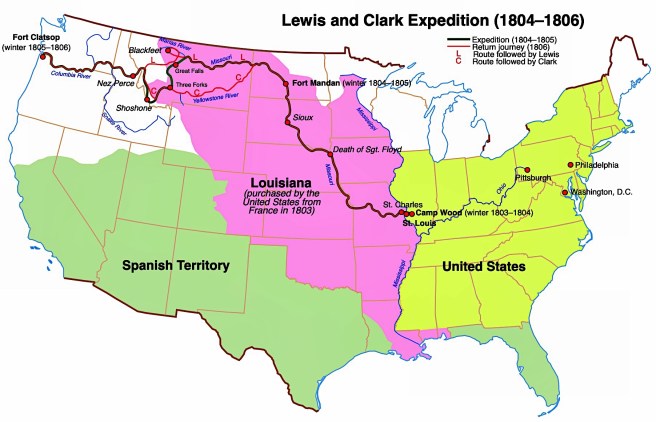
The route of the expedition was to start at St. Louis, to be able to ascend the Missouri River to its headwaters and then to discover whether any of the known rivers in the Oregon country either joined it or were in its proximity, thereby posing a potential all-water route to the Pacific. Jefferson, however, was politically more concerned about having a better understanding of what type of land and natural resources were contained in the Louisiana Purchase, in addition to strengthening the U.S.’s claim on the Oregon country by hoping that Lewis and Clark would beat the British and the Spanish in making the first claim of discovery in this region. While Lewis continued to address matters back east, Clark proceeded to erect the Corps of Discovery’s base camp, Camp Dubois, on American territory on the east bank of the Mississippi, some 15 miles upriver from St. Louis, directly across from the mouth of the Missouri River, where they were forced to wait until Spain, who had continued to administer Louisiana, formally transferred it to American authorities whose arrival had been postponed by ice on the Mississippi. Finally, the Spanish transferred St. Louis to French officials on March 9, 1804, who, after flying the French flag for one day, then turned the city over to American officials on March 10. The Corps then crossed the Mississippi on May 14, 1804, and would not return to St. Louis until September 23, 1806, some two years and four months later, having successfully reached the Pacific Ocean at the mouth of the Columbia River (near today’s Astoria, OR). Unfortunately, they reported that they did not find an all-water route to the Pacific Ocean. Travel to the Pacific Coast from the United States (i.e., the Atlantic Coast), therefore, would involve either the long, three to six-month long sea voyage around Cape Horn, or the arduous and dangerous land route from St. Louis through the northern Rocky Mountains.
FURTHER READING:
Andreas, Alfred T. History of Chicago, 3 vols. Chicago, 1884-1886. Reprint, New York: Arno Press, 1975.
Harpster, Jack. A Biography of William B. Ogden. Carbondale: Southern Illinois University, 2009.
Tallmadge, Thomas Eddy. Architecture in Old Chicago, Chicago: University of Chicago Press, 1941.
(If you have any questions or suggestions, please feel free to eMail me at: thearchitectureprofessor@gmail.com)
