
Chicago’s Canadian citizenship was short-lived, however, for the area was successfully invaded early into the American Revolution during the summer of 1778 by Lt. Col. George Rogers Clark leading a force of Virginia militia and volunteers who had gathered near the Falls of the Ohio, that marked the founding of the city of Louisville, named in honor of the King of the revolution’s French allies, King Louis XVI, whose town charter was approved by Virginia two years later in 1780. Clark’s force first captured the British forces at Kaskaskia (on the Mississippi in southern Illinois south of St. Louis) and then at Vincennes (in southern Indiana on the east bank of the Wabash River). The war was formally ended with the signing of the Treaty of Paris on Sept. 3, 1783, with all British lands east of the Mississippi and south of the Great Lakes falling under the auspices of the U.S. Congress of the Confederation that faced the task of the disposition and governing of these “unorganized” lands and their current indigenous populations. On April 23, 1784, Congress adopted a Land Ordinance, drafted by a committee of five delegates led by Virginian Thomas Jefferson that stated that the existing thirteen states would not expand into the territory west of the Appalachians based on their prior claims to the same, but that these states would cede these lands to Congress from which ten new states would be formed that would enjoy the same rights and responsibilities that the original thirteen states then did. Hence, Virginia ceded its territory in Illinois to the Congress, that in the meantime had begun planning the future sale and settlement of the lands inhabited by Native American tribes that lay west of the Appalachian Mountains, north of the Ohio River, and east of the Mississippi River by passing the Land Ordinance of 1785 on May 20. The Congress had drafted the ordinance as an orderly process to sell this newly acquired land as a method to raise funds for the Federal government that at the time did not have the legal authority to raise revenues through taxation. The 1785 Ordinance specified a plan to systematically organize the land rationally with the use of a Cartesian or rectilinear grid. The use of the grid to layout European cities dated back to ancient Greece during the 5th century BC. A number of colonial cities in America had been laid out on a strict gridiron of streets, New Haven, CT (1638), Philadelphia (1682), and Savannah (1733) being probably the best examples, but the scale of this latest application of the grid to lend order to such a large land mass was unprecedented.

This process for the organization of such a large land mass had originally been devised in 1764 by Thomas Hutchins, then a British captain in the Royal American Regiment, to establish an overall order to the land in northern Ohio surrendered by the French to the British following their defeat in 1763. At the time of the passage of the 1785 Ordinance, Hutchins was the Geographer of the U.S. and was tasked with the charge “to divide the said territory into townships six miles square, by lines running due north and south, and others crossing these at right angles… The plats of the townships, respectively, shall be marked into sections of one mile square, or 640 acres”. Therefore, unlike some American cities founded prior to 1785 such as Boston and New York (before 1811), whose street patterns reveal the influence of early human settlement and movement patterns as well as their response to local topographic features, Chicago’s future urban pattern of a rectilinear grid of streets (with the few exceptions of existing Native American paths) was influenced by Congress some forty-eight years before the town was first chartered.
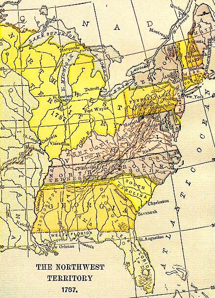
On July 13, 1787, the Congress created the first Federal territory in the U.S., with the passage the Northwest Ordinance (so named in that it addressed the status of “Territory Northwest of the Ohio River”). While the 1785 Ordinance had specified the system of how the land in this region was to be surveyed for future sale, this new Ordinance established how it would ultimately be governed. Among its provisions, the legislation changed the number of potential states to be formed within the region from Jefferson’s original ten to be no fewer than three nor more than five. While the Confederation Congress was addressing the disposition of the new lands in the NorthWest, it was also busy attempting to reconfigure the entire national government that had been established by the 1781 Articles of Confederation, into a more effective political system. Two months after the Congress had approved the Northwest Ordinance, it signed the new U.S. Constitution, a fully debated compromise between the two major competing socioeconomic visions for the new country. While these visions were not completely segregated between those in the North and those in the South, the vision shared by a majority of Southerners, best represented in the ideals of Thomas Jefferson (who eventually formed the Republican Party, now referred historically to as the Democratic-Republican party to distinguish it from today’s Republican party), envisioned “Arcadia,” a country formed of independent idyllic farms run by gentlemen within a federation of states united by Federal national government with limited powers (that did not include the funding of internal improvements such as roads), while the northern vision may best be represented by the ideals of Alexander Hamilton (who was to found the Federalist Party), who championed “Enterprise,” a country founded on unbounded trade, industry, and progress, made such by a strong, central Federal government (that could help the nation’s development by funding such internal improvements). Almost all political issues to face the new country, from tariffs to internal improvements, would be debated through these two lenses. The settlement and development of the trans-Appalachian lands would not escape this debate.
Significantly, the Northwest Ordinance prohibited the extension of slavery into these future states (no such prohibition applied to the territory south of the Ohio), overcoming earlier Southern Congressional resistance, and thereby, established the Ohio River as the de facto boundary between the North and South from the western tip of the Mason-Dixon Line, at the southeastern corner of Pennsylvania, to the Mississippi River. The main north/south boundary that would divide the new territory into its future states was logically determined by simply extending a boundary from the southern tip of Lake Michigan to the east to Lake Erie and to the west to the Mississippi River. This meant that the mouth of the Chicago River was not part of what was originally slated to be the state of Illinois but was planned to be included in the state of Wisconsin. This seemed consistent with the initial settlement pattern of Illinois, for while the French and British fur traders had come to Illinois via the Great Lakes, with the British controlling the St. Lawrence River and maintaining a strong presence along the northern shore of the lakes, immigrants and supplies from the American East Coast at this time had primarily come via the Ohio River to the southern portion of the future state from one of three routes, as there were few openings in the Allegheny Mountains that, for all practical purposes, had walled off the Atlantic Coast from the western hinterlands.

Settlers bound for the NorthWest who originated from as far north as downstate New York and as far south to northern Virginia could travel overland to either Pittsburgh or Wheeling (which is what the Treaty of Fort Stanwix in 1768 had attempted to stem, to little avail), where they would transfer to a vessel on the Ohio River, that flowed westward from its headwaters in the western foothills of the Allegheny Mountains, for their downriver destinations in the interior. However, they could also take the Potomac River in Virginia up to its headwaters at what is today Cumberland, MD, (not to be confused with the Cumberland Gap in Tennessee) and then set out overland along the old Braddock Road, the first trans-Appalachian route (that the British had cleared at the start of the French and Indian War in 1755 in order to capture Fort Duquesne (Pittsburgh) on the Ohio River), looking for one of the tributaries of the Monongahela River that would then take them to the Ohio River at Pittsburgh. Settlers from southern Virginia to Georgia, meanwhile, could take the route that Daniel Boone had blazed in 1775 through the Cumberland Gap into Kentucky and on to the Ohio River. Whichever route was chosen, the goal was to get to the Ohio River as easily as possible, that one could then float downriver to the new lands in the west.

The Ohio River, however, makes a sharp bend to the south some 100 miles upriver from Louisville that significantly increased the overland distance for those settlers destined for northern Indiana and Illinois. Just before the Ohio turns towards the south, the Licking River in Kentucky, almost as extensive of a waterway as the Kentucky River, empties into the Ohio. Across from the mouth of the Licking River, the Great and Little Miami Rivers with their combined watersheds reaching into the middle of Ohio, also empty into the Ohio River. It was here, then, that the settlement of Cincinnati was founded in 1788 (within a year of the passage of the Northwest Ordinance) as a departure port for lands in the NorthWest. With its shorter overland distance to the north as well as the combined inland watersheds of the Licking and Miami Rivers providing easy transport to inland markets, Cincinnati quickly surpassed Louisville that had no rivers into the interior, as the major port on the Ohio River.
Settlers moving into the Cincinnati region found it to be well suited for the growing of corn that could be easier transported to market if either distilled into whisky or fed to pigs. The pigs were easier to ship back east if processed into pork and lard. Cincinnati quickly became “Porkopolis,” the country’s largest pork-processing center. (Some of the lard in 1837 would be used by two brothers-in-law, William Proctor and James Gamble, to make industrial-processed soap, establishing one of the country’s largest and most stable companies.) Cincinnati’s location, at the midway point along the Ohio River, centered equally between and with easy river access to the newly-emerging markets in both the northern and southern states would allow it, although younger than St. Louis by some twenty-four years, to quickly surpass its western competitor in population and become the center of western business and migration from the antebellum Northern states, if for no other reason than St. Louis did not become part of the U.S. until the Louisiana Purchase was signed in 1803.
Although the British had ceded their claims to the NorthWest, no such arrangement had ever been agreed to by the Native tribes, who were reacting with increasing hostility to what they viewed as the illegal westward encroachment of the whites. It was not until the summer of 1794 that General “Mad Anthony” Wayne was able to subdue the tribes of the Western Confederacy at the Battle of Fallen Timbers (near today’s Toledo). Subsequently, Wayne forced an uneasy truce on the Natives with the signing of the Treaty of Greenville (Ohio) on August 3, 1795. Among its provisions, the Natives not only surrendered all claims to the lands in southern Ohio, but also agreed to cede to the U.S. “one piece of land six miles square, at the mouth of the Chicago River, emptying into the southwest end of Lake Michigan,” and to allow free passage “from the mouth of the Chicago River to the commencement of the portage between that river and the Illinois, and down the Illinois River to the Mississippi.” The young Federal government had its eyes on the Chicago region and the potential for a canal in this location for some thirty-five years before the town’s first Euro-American settlers had begun to displace its Native population.
FURTHER READING:
Andreas, Alfred T. History of Chicago, 3 vols. Chicago, 1884-1886. Reprint, New York: Arno Press, 1975.
Industrial Chicago-vol. 1: The Building Interests, Chicago: Goodspeed, 1891.
Lewis, Lloyd, and Smith, Henry Justin, Chicago: The History of Its Reputation, Rahway, N.J., 1929.
Pierce, Bessie Louis. A History of Chicago– 3 volumes. New York: Knopf, 1940.
(If you have any questions or suggestions, please feel free to eMail me at: thearchitectureprofessor@gmail.com)
