
CHAPTER 1. DREAMS OF A CANAL INSPIRE A CITY (1803-1830)
1.1. THE COLONIAL SETTLEMENT OF THE NORTHWEST
One fall day in 1673, Jesuit missionary Jacques Marquette and French Canadian voyaguer Louis Jolliet were paddling their canoe down what would they name the Chicago River when they caught their first glimpse of the river’s mouth into the vastness of Lake Michigan. If we look at the history of the Chicago region through an European lens and avoid the history of Native Americans, then Chicago began under the flag of the kingdom of France. Although Jacques Cartier had planted the first French flag at the mouth of the St. Lawrence River in 1543, claiming “New France” for his King, Francis I, the colony had only managed to marginally survive as a fur-trading enterprise along the river until King Louis XIV, who began to exert his royal authority following the death of his Chief Minister, Cardinal Mazarin in 1661, declared New France as a Royal Province in 1663 in an attempt to encourage its expansion into the Pais d’en Haut (“the upper country” to the west that included the Great Lakes) with the hope of finding the much sought-after Northwest passage to the Pacific Ocean and China. In 1668, a mission was founded at Sault Sainte Marie where Lake Superior flows into Lake Huron. Three years later in 1671 Jesuit missionary Father Jacques Marquette founded the Mission of St. Ignace on the north shore of the Straits of Mackinac that join Lake Michigan and Lake Huron, some forty miles south of Sault Sainte Marie. That same year Louis XIV had claimed formal possession of the entire Great Lakes region and the Mississippi Valley through the exploration of Daumont de St. Lusson, who made the formal claim at Sault Sainte Marie.
On May 17, 1673, Marquette, accompanied by voyaguer (a seasoned transporter of furs via canoe) Jolliet, set off from St. Ignace to explore the Mississippi Valley to determine whether it was the fabled Northwest passage. They took a route from Mackinac to the Mississippi, via the Wisconsin River, a route first traversed in 1634 by Jean Nicolet, another early voyaguer. They reached the Mississippi on June 17, 1673, and then traveled down the river for over a month until they reached the mouth of the Arkansas River. Here they learned from the local Native inhabitants not only that the river did not turn west to the Pacific, but also if they continued any farther south unfriendly Natives and Spanish soldiers (who had been exploring the lower Mississippi Valley for more than 130 years prior to the French expedition, starting with the Spanish explorer Hernando de Soto who in 1541 had first crossed the Mississippi River into northern Mississippi) could intercept them if they continued any farther. Therefore, Marquette and Jolliet reversed their course and headed back to Lake Michigan, returning in the fall of 1673. On their return they were directed by local Natives to take what is now the Illinois River back to Lake Michigan as a shorter route than from which they had started. After traversing up the Illinois River to its head at the confluence of the Des Plaines and Kankakee Rivers, they then followed the Des Plaines for some thirty-five miles, until they were led, via a short portage to a sluggish stream, the Chicago River that emptied into Lake Michigan.
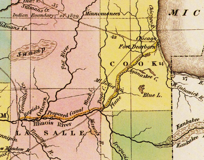
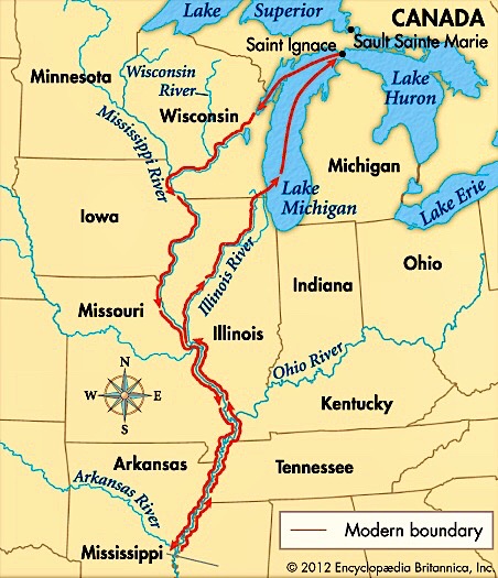
This allowed them to be the first documented Europeans to have set eyes upon the mouth of the Chicago River at Lake Michigan. The Native population had relied on this portage between the Des Plaines River, that flowed west to the Illinois River, and ultimately to the Mississippi River, and the Chicago River, which flowed east into Lake Michigan, for easy travel between the region’s two water systems. The portage, therefore, was an elevational plateau that divided the area’s drainage either west to the Mississippi River basin or east to the Great Lakes. During rainy periods, the portage itself often flooded, creating a “slough” or marsh that was called “Mud Lake” that made it possible to paddle between the two rivers.

The Chicago River, therefore, offered the potential to link the Great Lakes with the Mississippi River system with the construction of a relatively short canal between the Chicago and the Illinois Rivers. Although other sites on the western shore of Lake Michigan, such as the mouth of the Calumet River at the southern tip of Lake Michigan or the Milwaukee River at Milwaukee, WI, were found to have better harbors on Lake Michigan, Chicago’s only natural geographic feature – the close proximity of the Chicago River to the Illinois River – was sufficient argumentative evidence for the area’s supporter’s to successfully use against those who argued in favor of the other locations, in the coming debate for the Federal government’s support to build the canal that would make Chicago the lynchpin between two of the continent’s major antebellum water transportation networks: the Great Lakes via the Erie Canal, the industrial Northeast’s water route to the West, and the Mississippi River network, the lifeline of the antebellum agricultural South and upper Midwest. This potential had been acknowledged as early as 1673 by Jolliet who, following his return to St. Ignace, reported back to his King:
“We can quite easily go to Florida in boats, and by a very good navigation. There would be only one canal to make by cutting only half a league of prairie, [this was not an impossible task for the French at this time, as they were midway though the construction of the 150-mile long Canal du Midi, completed in 1681] to pass from the Lake of Illinois [Michigan] into the St. Louis River [the Des Plaines and Illinois]. The route to be taken is… Lake Erie to Lake Huron [to] the Lake of Illinois. At the extremity of this would be the cut, or canal,… to have a passage to the St. Louis River, which empties into the Mississippi… to the Gulf of Mexico… It would facilitate the communication from Quebec and Lake Erie… and but for a water-fall which separates Lake Erie from Lake Ontario, a bark… could go to Florida by the routes of which I have spoken.”
Although the mouth of the Chicago River would serve as nothing more than a settlement for itinerant French fur trapper/traders over the next century, Chicago’s European roots did reach back to Paris. In 1679, another early French explorer of the Chicago River, René Robert Cavalier, Sieur de la Salle, returned to the Illinois River, accompanied by the Jesuit priest Louis Hennepin. La Salle had first sent Hennepin to explore the upper Mississippi, who eventually reached the Falls of St. Anthony (that he recorded had a drop of over 50’), where Minneapolis was later settled. La Salle then set out in 1682 to explore the lower Mississippi. It took two months to reach the Gulf of Mexico on April 9, 1682, when he ignored the prior 140 year-old claims by the Spanish and claimed the entire river valley for his King and named it in his honor, “Louisiana,” that eventually evolved into two separate French administrative jurisdictions: Pais de Illinois (the Illinois Country), also referred to as la Haute-Louisiane (Upper Louisiana), comprised the land that lay north of the Arkansas River and was initially governed as part of the Province of Canada, and la Basse-Louisiane (Lower Louisiana) that extended south from the Arkansas River to the Gulf of Mexico.

The portage at the Chicago River ultimately became a heavily traveled route that linked new settlements in Upper Louisiana back to their supply centers in Canada. Meanwhile, in 1712, Louis XIV had granted a 15-year trade monopoly in Louisiana that now included Upper Louisiana, to his banker and financial advisor Antoine Crozat, the wealthiest merchant in France, who began the serious settlement of Lower Louisiana. This arrangement lasted only for five years, however, for following the death of Louis XIV, his successor, Phillipe II, the Duke of Orléans, Regent for Louis’ five-year old great-grandson who eventually would be crowned King Louis XV, formally established the Province of Louisiana in 1717, with New Orleans (founded in 1718 and named after the Regent) eventually becoming its capital in 1722. This arrangement lasted only a few years before hostile members of the Fox tribe moved into the upper Mississippi valley. They were incensed that the French had armed their rivals, the Sioux, and consequently forced the French to abandon the Illinois-Chicago route in favor of the more eastern and safer Ohio-Wabash River route to Lake Erie.
Following the defeat of the French by the British in the French and Indian War in 1763, under the provisions of the Treaty of Paris that ended the war, France surrendered all of its land in North America north of the Ohio River and east of the Mississippi to Great Britain. The land that France had claimed west of the Mississippi, however, was ceded to Spain. Within a year of the French surrender French fur traders who operated within the confluence of the Mississippi and Missouri Rivers, from where they then traveled up the Missouri River expanding the ever westward search of the fur trade, had relocated from the eastern bank of the Mississippi, that was now under direct British control, and taken up residence on the western bank of the Mississippi in 1764 as France and Spain were Catholic allies, founding a trading settlement they called St. Louis, named in honor of Louis IX, the famous “St. Louis.”

From the British viewpoint, however, the land west of the Mississippi had always lain within Virginia’s original colonial borders that extended “westward to the sea.” To reassure the Natives who were still sympathetic to the French but who were now to trade with and be governed by the British Crown, King George III followed the Treaty of Paris with a Royal Proclamation in October 1763 that forbade any Colonial government to grant, or any white man to claim any land defined as “beyond the sources of rivers that flow into the Atlantic.” As the Ohio and Mississippi Rivers flowed west, away from the Atlantic seaboard, this watershed was now officially off-limits to colonial speculators. The prohibition was reaffirmed in the Treaty of Fort Stanwix, signed with the Iroquois in 1768 that legally stymied the development plans of such famous colonial land speculators as George Washington and Benjamin Franklin. Following the Boston Tea Party of Dec. 16, 1773, Parliament attempted to strengthen the ban on trans-Appalachian settlement by passing the Quebec Act on June 22, 1774, one provision of which pushed the border of British Quebec south to the Ohio River. The mouth of the Chicago River, therefore, was then under the direct legal jurisdiction of Canada.
This prohibition had done little, however, to stem the growing tide of Euro-American settlers moving across the Appalachians and into the fertile lands of Kentucky. The first few Kentucky settlers had traveled down the Ohio, but in 1775 frontiersman Daniel Boone had managed to cut a route from Washington County in the southwestern tip of Virginia through the Appalachians at the Cumberland Gap where Virginia, Tennessee, and Kentucky all come together, known as the Wilderness Road. Boone eventually reached the Kentucky River at a point where he established the settlement of Boonesborough, KY, roughly 75 miles southeast of the Ohio River. From Boonesborough settlers could then take the Kentucky River to where it emptied into the Ohio River, some 50 miles upriver from the Falls on the Ohio (Louisville), the only impediment to navigation along the entire length of the river that forced travelers to portage around them.

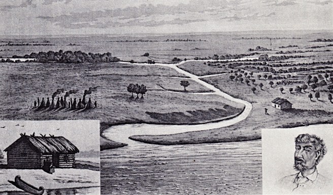
Meanwhile, the mouth of the Chicago River continued to remain unsettled with the only exception of the resident Native Americans and the few itinerant fur traders who continued to traverse the river. Jean Baptiste du Sable, a trader who dealt in furs and supplies, is the consensus among historians as the first non-Native “permanent resident” of the area. As he was not French, but the son of a Frenchman and a free black woman in Haiti, the Fox had allowed him and his wife to work his way up the Mississippi from New Orleans eventually settling in the Peoria region. He had expanded his operation to the mouth of the Chicago River in 1772 by constructing a trading post/log cabin on the north bank of the mouth of the river, to which he had moved with his family in 1774. Over the coming years, he expanded the outpost to a compound of nine buildings along the north bank of the mouth of the river that included his house (at what would be N. Water and Rush Streets), stables, a bakehouse, and a variety of farm buildings that stretched from the lake to what is now State Street and from the river to Grand Avenue.
FURTHER READING::
Andreas, Alfred T. History of Chicago, 3 vols. Chicago, 1884-1886. Reprint, New York: Arno Press, 1975.
Pierce, Bessie Louis. A History of Chicago– 3 volumes. New York: Knopf. 1940.
Wille, Lois. Forever Open, Clear, and Free; The Struggle For Chicago’s Lakefront. Chicago: Regnery, 1972.
(If you have any questions or suggestions, please feel free to eMail me at: thearchitectureprofessor@gmail.com)
