2.2. MOVING BEYOND ST. LOUIS: THE OREGON TRAIL

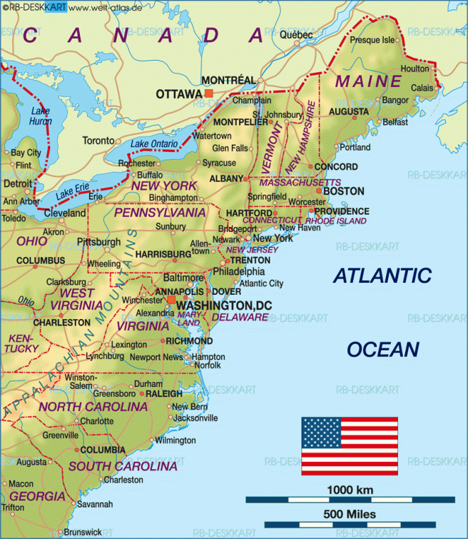
Meanwhile, during the intervening period between Lewis and Clark’s expedition to the Oregon country in 1803 and the Illinois’ legislature’s charge to Bucklin in February 1831, a clearer understanding of the geography that lay between the Mississippi River and the Columbia River basin in Oregon (remember, Mexico still controlled California) had begun to emerge, Perhaps the most important discovery, especially to the future interests of Chicago, was made in 1812, when a group of seven employees of John Jacob Astor’s ill-fated Pacific Fur Company who were retreating from the highly vulnerable Fort Astoria at the mouth of the Columbia River at the Pacific Ocean at the start of the War of 1812, discovered the South Pass in the Rockies in what is now southwestern Wyoming, that led to the Platte River, that they then followed to the Missouri River, eventually arriving at St. Louis.  South Pass turned out to be the lowest point of elevation crossing the continental divide, which together with the close proximity of the Sweetwater River (a branch of the N. Platte), made this route the easiest to traverse from the Mississippi Valley through the Rockies.  As far as Chicago’s long-term prospects, the South Pass was located along the 42° parallel, in a straight (railroad) line due west of Chicago, while St. Louis was over 200 miles south of the South Pass. 

The Oregon Trail. Note that South Pass is at the same latitude as is Chicago, whereas St. Louis is some 200 miles to the south. (Online)

The end of the War of 1812 had simply returned the status quo of the stiff competition between British and American fur traders to the upper portions of the Louisiana Purchase, but through the lobbying of Astor, Sec. of War Calhoun had been convinced of the need for another Federal expedition, to erect a series of military “outposts” along the northern reaches of the Missouri River. The Federal government commissioned five more military expeditions into the Spanish Southwest as well as the Northwest, that followed prior to 1820.The largest of these military expeditions occurred in the fall of 1818, when Calhoun had authorized what would be known as the Yellowstone Expedition led by Col. Henry Atkinson to explore the Missouri up to the mouth of the Yellowstone River. 

A scientific contingent that was to parallel Atkinson’s troops was led by military engineer Maj. Stephen H. Long, who had earlier conducted the first survey of the mouth of the Chicago River.  They departed from St. Louis in May 1819 in the first steam-powered riverboats used west of the Mississippi but got no farther than the mouth of the Platte River, known as Council Bluff at the time as Lewis and Clark had used the location to meet with the local natives at the start of their expedition. The winter of 1819/20 was particularly harsh, and then followed by the spring flooding of the Missouri, the troops were forced to build a fort atop Council Bluff, which they named Fort Atkinson, in honor of their colonel.  The primary reason for the failure of this mission was the government’s inability to supply troops for extended periods over such long distances, a problem that would vex such attempts, be they military or civilian, to penetrate the West for the next twenty-five years.

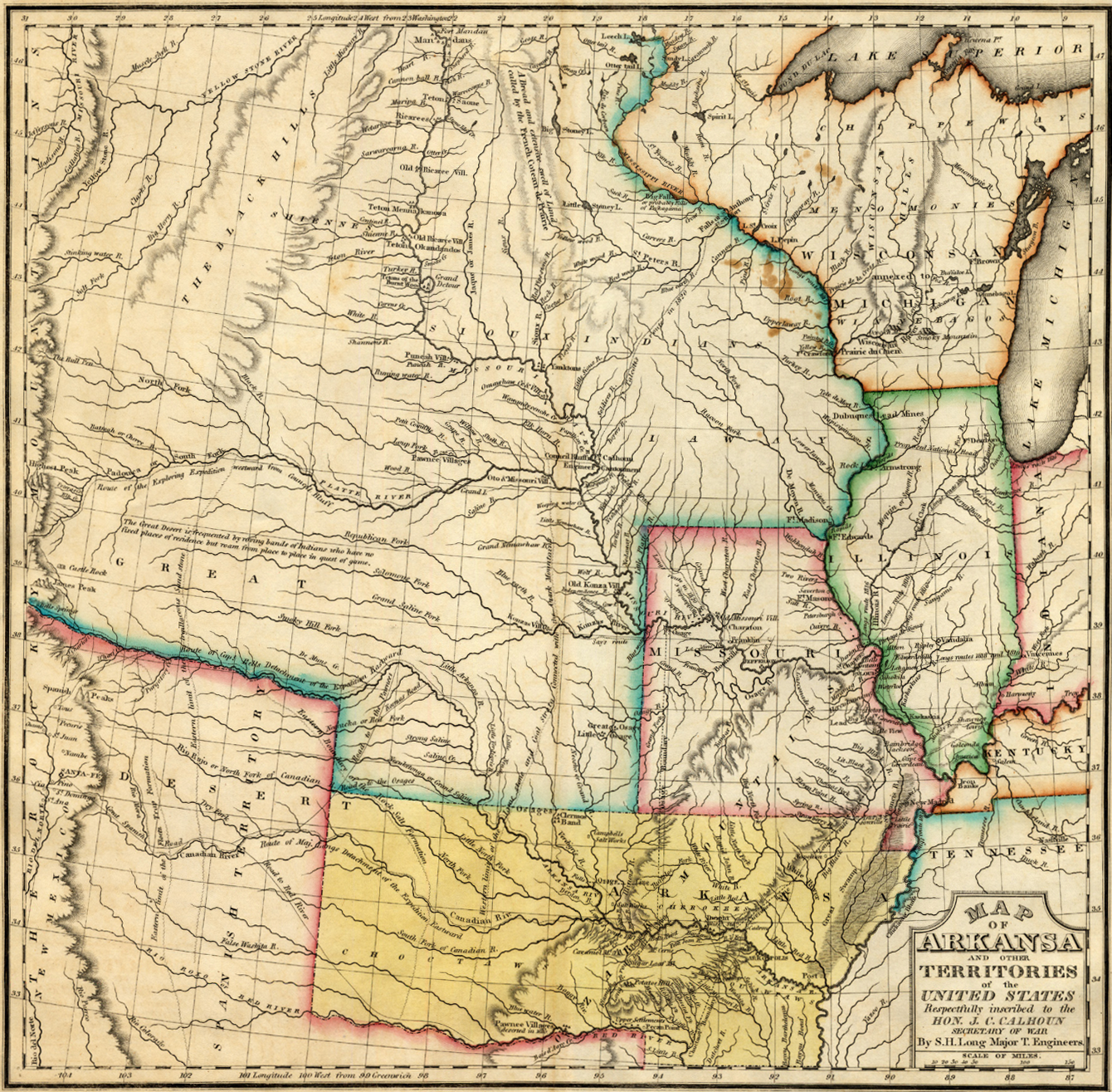
The failure of the mission, nevertheless, did not stop the Federal government from gathering information about the coveted lands west of the Mississippi.  In May 1820, Maj. Long was assigned to lead an expedition to up the Platte River to the Rocky Mountains and then reconnoiter the newly-agreed border with New Spain along the 42° parallel.  Upon his return, Long produced the first accurate map of the region in which he had located what he named “the Great Desert,” that “is frequented by roving bands of Indians who have no fixed places of residence but roam from place to place in quest of game.”  Long had identified the challenge in reaching the Pacific over a land route with limited supplies of water and timber.  Hemmed in by the Spanish to the south and the British in the north, Americans would have to find a route to the Pacific through what would be initially referred to as “The Great American Desert.”  

Map of the Region explored by Maj. Stephen H. Long, 1822. Note the designation, “Great Desert” marked in the lower left corner. (Online)

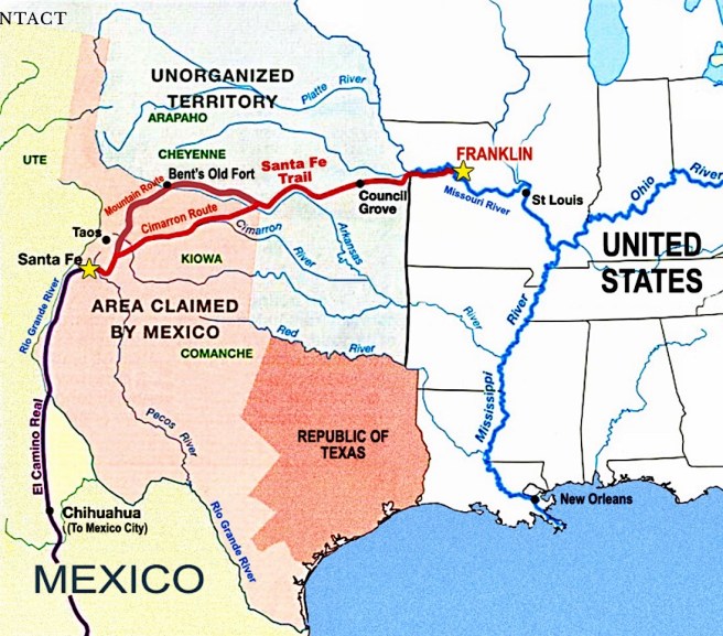
Thomas Hart Benton in his St. Louis Enquirer had continued during the early 1820s to encourage the efforts of the local fur trappers and traders commonly referred to as “mountainmen,” the most famous of which was Jedediah Smith, to continue to push ever farther up the Missouri and Platte Rivers, to explore the region in search of the most expedient route to the Pacific.  Unfortunately, the Native tribes of the Blackfeet and Arikaras along the upper Missouri route stood their ground, forcing these explorers to try the Platte River valley to the Central Rockies.  In 1823, a St. Louis fur trader, W.H. Ashley, followed the Sweetwater and rediscovered the South Pass, establishing the general route to the Pacific between British Canada (the 49° parallel) in the north and Mexico (the 42° parallel) to the south for what would be known as the Oregon Trail.  Benton’s Enquirer celebrated the discovery of the path to the Pacific: from St. Louis to the “river Platte a short distance above its junction with the Missouri, (it) then pursues the waters of the Platte to their sources, and … crosses the headwaters of what Gen’l Ashley believes to be, the Rio Colorado of the West, and strikes for the first time, a ridge… running from north to south.  This, however, presents no difficulty, as a wide gap [the South Pass] is found.”  Benton’s route to the Pacific was thus discovered, with the first trader wagon train to make this voyage, financed by Astor and under the command of Captain Benjamin Bonneville, had departed in 1832.  The jumping-off point from the Missouri River for the Oregon Trail was the same as that for the Santa Fe Trail, Independence, MO.  Anyone wanting to travel overland to the Pacific would start at St. Louis, and take the Missouri River to Independence, where one would outfit the necessary wagon required for the remainder of the trip overland to either Oregon or Nuevo México:

“On the mighty Mississippi, below the mouth of the vast extended Missouri, draining a country of unrivalled productiveness… capable of sustaining a population as dense as almost any region of the globe… While just above enters the Illinois, draining the very heart of that most productive State – while to the north… the states of Iowa and Wisconsin – the northern part of Illinois and Minnesota, each of them destined to sustain millions… of agriculturalists and mechanics, will always have their natural markets at St. Louis.

The pre-railroad routes to the West. The Oregon and Santa Fe Trails converge at Independence, MO, and then on to St. Louis. Note that Chicago isn’t even on the map. Nauvoo (home of the Mormons) is now the largest city in Illinois, with Galena falling to second, showing the early influence of the Mississippi on Illinois. (Online)

The development of the Oregon Trail, in conjunction with the Santa Fe Trail, therefore, seemed to codify Benton’s vision of St. Louis’ centrality in the American West.  That is, as long as water travel was the only mode of travel from the East, but fortunately for the future prospects of Chicago, the South Pass was located along the 42° parallel, in a straight (railroad) line due west of Chicago, while St. Louis was over 200 miles south of the South Pass.

Further reading:

Primm, James Neal. Lion of the Valley: St. Louis, Missouri, 1764-1980 (3rd ed.). Missouri Historical Society Press, 1998.

(If you have any questions or suggestions, please feel free to eMail me at: thearchitectureprofessor@gmail.com)

CHAPTER 2. CANAL VS. RAILROAD? (1831-1837)

The Illinois’ legislature’s charge in February 1831 to Bucklin to investigate the cost of building a railroad rather than a canal to link the two rivers at Chicago was not as bold as it might first appear, because at least eight railroads had already been chartered and were in various stages of construction in the U.S. by then.

Fig. 2.1. East Coast of U.S. locating the major cities where railroads were being discussed in 1831: Boston, New York, Philadelphia, Baltimore, and Charleston. (Online)

2.1. THE FIRST AMERICAN RAILROADS

Railroads pulled by draft animals had been in service in Europe to assist mining operations for decades before British engineer Richard Trevithick applied the new technology of steam power to build the first moving steam engine or “locomotive” that pulled a combined load of freight and passengers ten miles in Wales on February 21, 1804.  (See Chapter 8 for Trevithick’s proposed 1000’ iron tower in 1833.)  The first steam-powered railroad, the Stockton & Darlington Railroad, powered by Locomotion, the first of many steam-powered locomotives designed by engineer George Stephenson had had its inaugural run on September 27, 1825.  These pioneering experiments in Great Britain were eagerly followed by Americans interested in applying this technology in the U.S., where horse-drawn railroads also predated the first steam railroads.  The first documented American horse-drawn company, the New Jersey Railroad Company was chartered on February 6, 1815, in New Jersey some ten years after Trevithick’s invention by Col. John Stevens, a lawyer and engineer who lived in what is now Hoboken, NJ, to create a land link between Philadelphia (at Trenton, NJ on the Delaware River) and New York City (at New Brunswick on the Raritan River).  The impending completion of the Erie Canal a decade later, however, was changing the economic calculus along the Eastern seaboard in favor of New York City, whose economy was beginning to overtake that of Philadelphia as the country’s financial center.  Stevens, America’s pioneering railroad visionary who was responsible for many inventions, including the country’s first steam-powered locomotive, eventually also succeeded in having the Pennsylvania legislature charter a second railroad on May 13, 1823, to run between Philadelphia to Columbia, PA, on the Susquehanna River, just upriver from Harrisburg, the state’s Capital.  Stevens had foreseen the potential of the railroad as Philadelphia’s salvation in its struggle to keep the Erie Canal and New York City at bay, and therefore, Stevens’ ultimate objective was nothing short of a vast interstate network of railroads that emanated from Philadelphia in order to maintain Philadelphia’s standing as the country’s largest city and financial center: 

“And when this great improvement in transportation shall have been extended to Pittsburgh, then thence into the heart of the extensive and fertile State of Ohio, and also the great western lakes, Philadelphia may then become the grand emporium of the western country… The improvement, when once introduced, will unquestionably be extended from Philadelphia across New Jersey to the city of New York.”

To prove the feasibility of a steam railroad, Stevens in 1825, the same year that Stephenson’s Locomotion pulled the first train in Britain, built a small steam-powered train that ran on a circular track on his Hoboken estate.  But he was fighting a very uphill battle because canal interests throughout Pennsylvania, inspired by the imminent completion of New York’s Erie Canal, would see to it that Pennsylvania would lag behind its competitors in the adoption of the railroad with the legislature’s passage of a series of bills in 1826 that formed the state’s Main Line of Public Works that called for a system of canals to link Philadelphia with Pittsburgh, and thus, via the Ohio River, to the NorthWest.  Railroads would eventually be incorporated into the system, but only as a means of linking one canal to another. 

Although Stevens was the first American to follow British’s railroad experiments, It took only three months after the start of Stephenson’s Stockton & Darlington for George Featherstonhaugh, a British immigrant who also was a follower of Stephenson’s work, who lived in upstate New York near Schenectady, to publish an announcement on December 28, 1825, stating that he planned to apply for a charter to build a railroad from Albany to Schenectady on the Mohawk River.  Although the New York legislature finally granted the charter for the Mohawk & Hudson on April 17, 1826, canal interests and Albany boosters fearing the proposal, added enough prohibitive provisions to it that, for all practical purposes, the project was stillborn for the foreseeable future.  While the New York legislature had debated Featherstonhaugh’s proposal. The Massachusetts and Pennsylvania legislatures had each approved a railroad charter in their respective states.  On March 4, 1826, the Massachusetts legislature approved the third American charter to build a railroad (although it, too, was to be horse-drawn) in the U.S., the Granite Rail-Road, to a group of Boston investors, led by Thomas H. Perkins, the city’s leading patrician, planning the construction of the Bunker Hill Monument (see Chapter 4).  And then only the week before New York had granted the M&H its charter, the Pennsylvania legislature approved a charter for the Delaware & Hudson Railroad on August 8, 1826, to build a railroad to ship coal from a mine in Carbondale, PA, to the company’s Hudson River canal at Honesdale, PA.  John B. Jervis, a self-taught engineer, who had been the resident engineer for a 50-mile segment of the Erie Canal, had been named the railroad’s chief engineer and had sent one of his associates, Horatio Allen, to Great Britain in 1828 to supervise the manufacture of four locomotives of Jervis’ design. The Stourbridge Lion arrived in 1829 and made the first run of a steam-powered locomotive in the U.S on August 8, 1829.   While this locomotive had worked successfully, it was ultimately abandoned as it was too heavy for the American track in use at the time. 

The sixth American railroad chartered was the Baltimore & Ohio Railroad that had been chartered on February 28, 1827, by Philip E. Thomas and George E. Brown of Baltimore with the expressed intent of building a railroad to the Ohio River so as to reduce the overland travel time of goods departing from Baltimore along the National Road to Wheeling for eventually shipment on the Ohio, as an attempt to counteract the economic advantage that New York had gained with the completion of the Erie Canal. In essence, it was a parallel proposal to the Chesapeake & Ohio Canal, upon which construction as of yet had not started. The history and success of the B&O was intertwined with that of Peter Cooper, a shrewd businessman and inventor from New York City at the time, who was a perfect example of the interrelatedness of the initial use of iron between that in the railroad and that in the construction of buildings.  Believing that the construction of the B&O would greatly increase the value of land along its proposed route, Cooper had purchased over 3000 acres in Maryland, upon which he discovered a rich vein of iron ore.  Naturally, he founded the Canton Iron Works in Baltimore to fabricate some of the iron components needed by the nascent company, and when the railroad ran into technical problems with its development of a locomotive, Cooper voluntarily stepped in with his own design of the Tom Thumb, the first American designed and built locomotive, made famous by its race on August 28, 1830, with the horse, Lightning (which it lost only after having suffered a technical malfunction).

Charleston, SC, another harbor on the Atlantic Coast in competition with New York, not only had much the same reaction to the Erie Canal as had its other competitors but was also under growing competition for its traditional inland cotton exports with its neighbor, Savannah, GA, that enjoyed the deeper inland penetration of the Savannah River, that allowed growers in South Carolina an easier (and less expensive) route to the Atlantic.  Charleston’s leading businessmen had the foresight to understand how the railroad could divert some of this trade to Charleston by building a railroad from Charleston to Hamburg, SC, directly across the Savannah River from Augusta, GA, and succeeded in having the South Carolina legislature charter the seventh American railroad, the South Carolina Canal and Railroad Co., on Dec. 19, 1827.  They made little progress, however, until they obtained the services of Horatio Allen from the Delaware & Hudson Railroad, who had made the first run of the Stourbridge Lion in 1829.  Four months after the race between the Tom Thumb and Lightning, the SCC&RR on December 25, 1830, made its first run of its first locomotive, David Matthew’s the Best Friend of Charleston.

By this time, investors in Philadelphia and Boston had finally awoken to the financial possibilities of the new technology and had chartered their own railroads.  Col. Stevens’ son, Robert L. Stevens, chartered the Camden & Amboy Railroad in New Jersey, the eighth such American company, on April 28, 1830, to build a route from New York City (by ferryboat over Raritan Bay to South Amboy, NJ) to Philadelphia (by ferryboat across the Delaware River from Camden, NJ).  Five weeks later, Boston investors once again led by Perkins, having been successful with the Granite Rail-Road, had chartered America’s ninth railroad, the Boston & Lowell Railroad to connect Boston with the textile mills at Lowell on June 5, 1830.  This would be the first in a system of four lines that radiated out from Boston that would make Boston’s the largest rail network in the U.S. when it was completed in 1835.

These successful experiments with the railroad appear to have finally convinced a group of prominent New Yorkers including John Jacob Astor, to buy into Feathersonhaugh‘s Mohawk & Hudson, whose construction had languished for over three years since its chartering, and take control of the project and then forced Feathersonhaugh to resign.  Engineer Jervis was brought in by the new management and began construction on the M&H on July 27, 1830. Seven months later, Jervis had completed the sixteen miles of the M&H and the maiden voyage of the somewhat ironically named DeWitt Clinton (who had died in 1828) took place on August 13, 1831.  Therefore, within a period of five years following the completion of the Erie Canal, all five major Atlantic ports, Boston, New York, Philadelphia, Baltimore, and Charleston, had responded to the immediate economic success of the Erie Canal by starting construction of their own railroads to the western hinterlands. Only time would tell which one would win the battle to the west and become the nation’s economic capital.  Any or all of these projects could have inspired the Illinois Legislature to explore the feasibility of building a railroad rather than a canal to link the Chicago River to the Illinois River in 1831.

FURTHER READING

Galloway, John Debo, The First Transcontinental Railroad, New York: Simmons-Broadway, 1950.

Grant, H. Roger. The Louisville, Cincinnati, & Charleston Rail Road. Bloomington: Indiana University Press, 2014.

Harlow, Alvin F., The Road of the Century, New York, 1947.

Kirkland, Edward Chase, Men, Cities, and Transportation: A Study in New England History (1820-1900) – Volume I, Cambridge, 1948.

(If you have any questions or suggestions, please feel free to eMail me at: thearchitectureprofessor@gmail.com)

1.16. PLATTING THE TOWN OF CHICAGO IN THE PRAIRIE WILDERNESS

U.S. Bureau of Land Management map showing the Principal Meridians and Baselines in Illinois, Indiana, and Ohio. (Online)

Bolstered by such largesse at the expense of the public (or more accurately, the Native Americans), the Governor appointed a new, second canal commission on January 22, 1829, to survey towns along the canal’s path and to oversee the sale of the land.  In the fall of 1829, the Commissioners ordered the survey and platting of a town, adjacent to Fort Dearborn in Township 39, Section 9 in which was located the main branch of the river.  

Township Map of Illinois, showing the Third Primary Meridian at the mouth of the Ohio River into the Mississippi River, and the Centralia Base Line. (Online)
Map of Chicago showing the township and section boundaries within the city limits, 1867. The start of the canal at Canalport is marked by the dot. (Andreas, History of Chicago-II)

Due to how the state had been originally surveyed starting from the intersection of the Third Principal Meridian and the Centralia East/West baseline, Section 9 that today is bounded by Madison, State, Chicago, and Halsted Streets, was unique in that it is the only section that encompasses all three branches of the Chicago River: the Main Branch, as well as the North and South Branches of the Chicago River that joined at a location commonly referred to as Wolf Point.  In other words, the Main Branch of the Chicago River split at this juncture into the South Branch that led to the Des Plaines River, and the North Branch that continued northward for some forty miles.  (These three branches created a Y-shaped, three-part division of the city that would be formalized in the City Charter of 1837 as the North, South, and West Divisions, a pattern that would typically pit one area versus the other two, depending upon the politics of a given issue.)  

Wolf Point, 1830. The junction of the North and South Branches into the Main Branch of the Chicago River. (Above: Andreas-History of Chicago-I; Below: CHS Society Painting)

Surveyor James Thompson was hired by the Canal Commissioners to finally extend Illinois’ Cartesian grid into the area at the mouth of the Chicago River, that at the time was said to have been inhabited by Fort Dearborn and some forty people (Galena’s population at this time had already exceeded 10,000), primarily engaged in the fur trade and supplying the local Native people.  Thompson had few buildings to contend with: 

“The Agency occupied the center of North State street, near the river bank; that of McKee stood at the southwest corner of State and Kinzie, and extended into the present State street; Portier’s cabin was a little southwest of McKee’s and Wolcott’s log house, on the river bank, southwest of Portier’s; John Miller’s cabin fronted on the river, at Wolf Point, between the north branch and the bayou, and Mark Beaubien’s first frame house, on what is now the southeast corner of Lake and Market… J.B. Beaubien’s store, on the west bank of the old river, Fort Dearborn, at the corner of River street and Michigan avenue, Craft’s store and house, on the northwest corner of Madison street, opposite (the) mouth of old river, and the Kinzie house, on the river front, between Rush and Pine streets, were all east of the original plat.”

South Water Street, ca.1832. This print was made in 1902, as a recreation of the area as it was in 1834. The area was much more built up in 1834 than pictured here, therefore, the scene is more accurate for a few years earlier. The Dearborn Street drawbridge at the far right should, therefore, not be included as it was not completed until August 1834. (Mayer and Wade, Chicago: Growth of a Metropolis)
Fort Dearborn and Environs, c. 1834. The three sloughs off the Main Branch are indicated. (Holland, Maps of Chicago)

Thompson limited himself to only the areas immediately adjacent to the banks of the river, that is, only the southern half of the section (the section is bordered on the north by Chicago Avenue and on the west by Halsted) stopping at Kinzie and at “Des Pleins” (sic). Respecting the original north-south orientation of the boundaries of the townships and sections established by the Land Ordinance of 1785, he subdivided this portion of the section into a strict rectilinear grid of twelve blocks by twelve blocks, the standard block had dimensions of 320’ (four lots that were 80’ wide) e/w and 360’ n/s (two lots that were 180’ long-minus an 18’ alley) with 80’ wide streets. He assigned names to the streets employing either recent heroes (Washington, Dearborn, Clark) or local features (Lake, Canal, Water).  

From the portion of Section 9 that he surveyed, one can surmise that Thompson had begun at the Section’s southeast corner and set the future northwest corner of Madison and State at this point: some 233 miles north of the Centralia East/West baseline, located just to the south of Centralia, IL, and 81 miles east of the mouth of the Ohio River into the Mississippi River at Cairo, IL, the position of the Third Principal Meridian.  Chicago’s future street pattern was thus rationally imposed by humans within the overall grid of Illinois, with no influence whatsoever from the local natural context, but instead, located so many miles east of the mouth of the Ohio River into the Mississippi, and so many miles north of the arbitrarily imposed east/west baseline.

Following the method of platting a township into sections (as adopted by the General Land Office on May 18, 1796), Thompson consecutively numbered the blocks, starting in the northeast corner (southwest corner of State and Kinzie) and running west, and then dropped one block south and returned eastward, altering the shape and sizes of the blocks only when needed to accommodate the three branches of the river.  The section’s eastern boundary was where Thompson had set what was to eventually become State Street, as he had no orders to plat beyond the limits of Section 9.  He did not venture across State Street into Section 10, as the Federal government had claimed the lakefront in the southern portion of Section 10 around the fort and it would obviously not be for sale at this time, a fact that would eventually prove to be a blessing for the long-term future of the city’s residents. Thompson formally filed his plat for the “Town of Chicago” on August 4, 1830.  As there was no town there at the time, there was also no existing village green or town commons, so typical of New England villages.  Thompson would make one last decision that would have a permanent impact on the future city’s overall urban fabric, before he handed the land over to the free market to do with it as it pleased: he arbitrarily established block 39, bounded by La Salle, Washington, Clark, and Randolph, that was somewhat centrally positioned within the area south of the river’s main branch, to be the town’s future Public Square.  It would be up to the city leaders in the future to encourage this block to eventually look, feel, and function as a town square.

James Thompson’s Plat of Township 39, Section 9 (Town of Chicago), August 4, 1830. Note he has penciled in “Town Square” in Block 39, bounded by La Salle, Washington, Clark, and Randolph. (Holland, Chicago in Maps)

Unfortunately, the optimism reflected in Thompson’s platting of lots at the mouth of the Chicago River did not induce potential canal lot buyers, for without the finished canal the land had little intrinsic value, and few lots were sold.  The ongoing survey of the canal route, finally completed in early 1831, had only compounded the project’s problems.  The 96-mile route of the canal was to start at Canalport (29th and Ashland) in Chicago (that would later be known as Bridgeport) and connect with the Illinois River at La Salle, IL, just downriver from the rapids at Starved Rock, where sandbars caused by the Vermillion River emptying into the Illinois prevented any farther navigation upriver.  Although the canal route never physically incorporated the Des Plaines River, it did parallel the Des Plaines for the ease of its geologic elevation as well as for the ability to supply the needed water for the canal, especially during dry seasons.  Rock, however, was found close to the surface at the Des Plaines River at a point where it had been planned to make a 6’ deep cut to accommodate large vessels with deeper draughts for a continuous-slope route from Lake Michigan.  The cost of such excavation was seen to be so prohibitive that the legislature appointed another commission in February 1831 that charged Chief Engineer James M. Bucklin to not only to explore other routes but also to study the feasibility of employing the newly-developing technology of the steam railroad rather than a canal to link the two rivers. Thompson’s surveyed lots along the Chicago River would remain vacant marshland as the state government continued to debate the project during the next two years.  

Map of Bridgeport (originally Canalport), the start of the I & M Canal at Ashland and 29th (dot). (Andreas, History of Chicago-I)

Further reading:

Andreas, Alfred T. History of Chicago, 3 vols. Chicago, 1884-1886. Reprint, New York: Arno Press, 1975.

Holland, Robert A. Chicago in Maps: 1612-2002. New York: Rizzoli, 2005.

(If you have any questions or suggestions, please feel free to eMail me at: thearchitectureprofessor@gmail.com)

1.15. IMPROVING THE MOUTH OF THE RIVER

William Howard, Proposed improvements to the mouth of the Chicago River, 1830. (Sprague, JSAH, December 1981)

It took another Federal financial commitment, however, before interest in the canal would spark speculation in the new paper town.  The sandbar that had been formed at the river’s mouth by the lake’s current that had deflected the path of the river to the south for the equivalent of five city blocks, was preventing all but vessels of the shallowest draught from entering the river.  Lake vessels, therefore, were forced to anchor a half-mile offshore, quickly transfer their cargoes to lighters to be taken ashore and raise anchor to speedily return to the safety of harbors in the north before a storm blew up.  Major Long, in his 1816 survey report had identified this potential problem and correspondingly, had proposed constructing two piers at the sandbar that would then allow the cutting of a channel through the sandbar.  It would soon become apparent that the construction of the canal would simultaneously require improvements at the mouth of the river if the endeavor was to ultimately succeed.  Schoolcraft was the first to comment on and offer an alternative to clearing the mouth of the river during a visit in 1821:

“We allude to the formation of a harbor on Lake Michigan where vessels may be in safety while they are discharging the commodities destined for Illinois… It is well known that… there is no harbor or shelter for vessels in the southern part of Lake Michigan, and that every vessel which passes into that lake after September, runs an imminent hazard of shipwreck.  Vessels bound for Chicago come to anchor upon a gravelly location in the lake, and discharging with all possible speed, hasten on their return.  The sand which is driven up into the mouth of the Chicago Creek will admit boats only to pass over the bar… It is yet somewhat problematical whether a safe and permanent harbor can be constructed by any effort of human ingenuity, upon the bleak and naked shores of these lakes, exposed, as they are, to the most furious tempests.  And we are inclined to think it would be feasible to construct an artificial island off the mouth of the Chicago Creek, which might be connected by a bridge with the mainland… with less expense than to keep the Chicago clear of sand.”

In 1829, following the passage of the canal landgrant, Illinois’ Congressmen were told to press the harbor issue in Washington to secure Federal funding for the needed improvements.  They succeeded, for in February 1830 William Howard, chief engineer of the Federal Topographical Bureau, developed and submitted a plan for “improving the mouth of the Chicago River” that echoed Long’s fourteen-year-old proposal of straightening the river’s path to the lake by cutting a channel through the sandbar and protecting the new outlet by extending piers into the lake as had just been completed across the lake at Michigan City. 

The Mouth of the Chicago River, 1820. (Upper: Historic Maps and Views; Below: Andreas-1, History of Chicago)

The study was used by the state’s Representatives to bring the harbor issue once again to the attention of Congress that in March 1831 approved a $5000 appropriation toward the erection of a lighthouse at the mouth of the Chicago River.  Unfortunately, just prior to its completion, the fifty-foot tower that employed brick walls nearly three feet thick, collapsed on October 30, 1831.  While the contractor, Samuel Jackson, claimed that it “was built on quicksand, which caused it to settle and fall,” others claimed that the construction was defective.  

Chicago’s geology presented two problems to would-be builders.  The original soil consisted of a foot of black loam followed by a three- to four-foot layer of “quicksand,” that was finally supported by an eight- to twelve-foot depth of impervious blue clay.  Complicating matters further, the elevation of the original topography east of State Street lay from nine to ten feet above the surface of the lake, whereas to the west of State Street, it sloped down to the river in a level plain elevated only two to three feet above the river, hence natural surface drainage was practically nil.  The shallow depth of the ground water so near the lake also prevented most excavation and, subsequently, any subgrade basements. Chicago’s harsh winters only compounded the problems faced by Chicago’s builders: the frostline (the depth of frost penetration) is 42.”  In other words, imagine trying to place a footing that deep while the ground water is filling in the hole you are trying to excavate.  This was an expense few builders were willing to take in the early days, resulting in footings placed with a shallow depth, in ground that tended to freeze in the winter.  Water expands when frozen that results in “frostheave:” the ground raises (with the building on top of it) but typically in an uneven manner.  In the spring the ground thaws, and the buildings settle unequally, with cracks appearing.

The drainage problem was only compounded by the layer of blue clay that prevented surface water from being absorbed any farther into the ground.  Therefore, rain, snowmelt, and sewage had but one mode of dispersal: evaporation.  Except for brief periods in dry summers, Chicago was, for all practical purposes, a city of mud.  John Mills Van Osdel, Chicago’s first architect, described the problem this posed to Chicago’s early builders:

“This sand in wet seasons became saturated with water, which could not pass downward into the clay, nor laterally as there was no inclination of the strata.  There was nothing left but evaporation, which at times was a very slow process in rendering the soil firm and dry.   In digging post-holes or trenches for foundations, the water would fill such excavations full to the surface of the ground…  A majority of the earlier frame buildings rested on posts sunk through the quicksand to the clay.  The greatest difficulty was experienced in the arrangement of the necessary privy-vaults.  They would fill with water to the surface of the ground.  An embankment had to be formed around them to prevent their overflow, and they required constant watchfulness to keep them in a moderately sanitary condition.”

Although Chicago’s first attempt at a tall structure, Jackson’s lighthouse, had been claimed by the town’s fickle soil, he did succeed in erecting a similar but slightly shorter (and, notably, lighter in weight) version the following year.

Mouth of the Chicago River in 1838. Chicago’s first masonry tower, the Federal lighthouse built in 1832 by Samuel Jackson, stands to the right of the deteriorating Fort Dearborn. (Mayer and Wade, Chicago: Growth of a Metropolis)

Further reading:

Andreas, Alfred T. History of Chicago, 3 vols. Chicago, 1884-1886. Reprint, New York: Arno Press, 1975.

(If you have any questions or suggestions, please feel free to eMail me at: thearchitectureprofessor@gmail.com)

1.13. THE FEDERAL LANDGRANT FOR THE CANAL

Meanwhile, the newly created state of Illinois wasted little time in initiating plans for the Chicago canal’s construction.  The governor of the new state, Shadrack Bond, ordered the first survey of the strip of land previously ceded by the Natives in 1816, and in June 1821 Surveyor John Walls surveyed Township 39 North of the baseline, Range 14 East of the Third Principal Meridian imposing the geometric rigor of the 1785 Land Ordinance onto the virgin prairie along the Chicago River. Gov. Bond also proposed that some of the proceeds from the sale of lands set aside by the Federal Enabling Act for the construction of roads be diverted to help pay for the canal.   Consequently, Illinois Senator Jesse B. Thomas and Congressman Daniel P. Cook set out to secure the support of the Federal government for this endeavor.  Their initial labors achieved a modicum of success when Congress voted on March 30, 1822, to give the state permission to dig the canal on Federal property. 

John Walls’ Survey of Township 39 North, Range 14 East, June 1821. The rational order of the human mind is imposed upon the topography surrounding the Chicago River. (Holland, Chicago in Maps)

More importantly, however meager it may have appeared, Congress not only voted $10,000 to pay for the surveys already begun, but also donated a strip of land comprising ninety feet on each side of the proposed route as well as all material (timber, etc.) on the adjacent public land.  Congress had set the precedent for granting former lands of the Native tribes to the states to fund internal improvements some twenty years earlier in 1802, when it gave “public lands” in Ohio to finance the construction of roads. Thus encouraged, the Illinois House established on February 14, 1823, a canal commission to complete the surveys and prepare an estimate of the cost to construct the canal.  Undoubtedly encouraged by the imminent completion of the Erie Canal scheduled for October 1825, the Illinois & Michigan Canal Company was optimistically incorporated on January 17, 1825, with stock initially valued at $1 million.  Sufficient private capital, however, was not willingly committed to such a long-term venture, so the legislature annulled the company a year later.  Pressure then began to build on the State, however, to start construction on its canal, so the state, following the highly-contentious Presidential election of 1824 that saw the election of Massachusetts’ John Quincy Adams, over Andrew Jackson by a single vote in a run-off election in the House of Representatives, who was more predisposed to internal improvements than had been the Virginians Jefferson, Madison, and Monroe, Illinois sent Cook back to Washington, hoping to increase the Federal government’s investment in the canal.

Once back in Washington in 1826, Cook was able to use the completion of the Erie Canal in the previous October to aid his argument.  The Erie Canal’s Grand Celebration on October 26, had begun with a successive cannonade by canons placed within earshot of each other starting at Buffalo along the entire length the Canal and down the Hudson River to New York City and back.  The “Grand Salute” took three hours and twenty minutes.  Meanwhile a flotilla of canal boats, led by Gov. Clinton aboard the Seneca Chief, departed on a ten-day trip to New York City, where Clinton ceremonious poured a keg of Lake Erie water into New York Harbor, consummating the “Wedding of the Waters.”

Cook pursued Federal funding for the Chicago canal claiming that it was an issue of national, and not merely regional importance due to its potential ability to facilitate troop and supply movements during wartime, citing the now completed Erie Canal.  Illinois’ political hunch to approach the new Congress and President paid off as the constitutional logjam over the role of the Federal government in Internal Improvements was broken by Adams with his goal of a national system of transportation and communications. (If Jackson had won the election, it is quite conceivable, based on his later record on internal improvements, that the canal would have remained still-born for the better part of what would have been Jackson’s eight year term.  Therefore, Adams’ election was critical to the founding of Chicago, for without the 1827 landgrant, there would have been no funding for the canal, let alone the surveys needed to sell the real estate at the mouth of the river.)  

Survey and Land Grant Map, Illinois and Michigan Canal, 1829. Note the alternate sections given to the state by the Federal government, the sale of which was intended to finance the construction of the canal. (Roche, Plans of Chicago)

On March 2, 1827, Congress approved a landgrant to Illinois consisting of the original landgrant, as well as the alternate five sections (commonly referred to as the “checkerboard system”) within a ten-section width that followed the canal’s route.  The sale of this land that totaled in excess of 284,000 acres (the equivalent of a width of five square miles along the path of the canal), was intended to help finance the construction of the Chicago canal.  The plan was quite straightforward.  The state would first sell the land in its sections to private citizens, in order to generate funds to pay for the canal’s construction, while the Federal government held onto its alternating sections for sale at a later date.  Theoretically, the construction of the canal and the corresponding improvements made in the state’s sections would increase the value of the Federal holdings, so that when these were sold, the Federal government would recoup the cost of the initial giveaway to the state.

1.14. THE DEMOCRATS TAKE CONTROL: ANDREW JACKSON AND MARTIN VAN BUREN

While one could credit Pres. Adams’ support for internal improvements as having encouraged these early efforts to build a network of roads and canals throughout the country, his involvement was to be short-lived as Jackson, who approached the 1828 election as a duel to regain his lost honor after the 1824 election, easily defeated Adams’ reelection bid. The 1828 election marked the end of the unity of the “Era of Good Feelings” as the Democratic-Republican Party of Thomas Jefferson split between those who backed Adams, who eventually were referred to as “National Republicans,” and those who supported Jackson, who eventually dropped the word Republican from their party, preferring to known as “Democrats.”

As Jackson mounted his campaign to challenge Adams’ reelection in 1828, he was courted by then Gov. DeWitt Clinton and Sen. Martin Van Buren, the leaders of the two factions of the most influential state political party in the North, New York’s Democratic-Republican Party. Martin Van Buren (note: he will be responsible for the most impact on Chicago’s early growth) had been born in Kinderhook, NY, just south of Albany, and after having finished his law studies, had gravitated to New York State politics in Albany, a field for which his innate talents of genial conversation and perpetual scheming would serve him well.  Following DeWitt Clinton’s election in 1813 as the Mayor of New York, coming after his unsuccessful bid to oust Pres. Madison, Van Buren had joined the “Opposition Party,” the Albany faction of New York State’s Democratic-Republican Party who opposed Clinton’s faction (whose power base was in “downstate” New York City).  Following Clinton’s election as Governor on July 1, 1817, Van Buren had formed the “Bucktail” faction of the party, in conjunction with and modeled after New York City’s Tammany Hall, the original target of Mayor Clinton’s political reforms, (Van Buren had even chosen Tammany’s symbol, a deer’s tail worn in one’s hat, as the new group’s symbol.) to oppose Gov. Clinton’s control of the party and its patronage throughout the state.  Van Buren used the new organization to leapfrog over Clinton onto the national political stage with his election to the U. S. Senate in late 1820.  In order to oust Clinton as Governor, Van Buren then formed and became the leader of the “Albany Regency,” one of America’s early political machines that ran the state’s Democratic-Republican politics through tight organization and by controlling the patronage that flowed from the New York State Capitol.  Meanwhile in the U.S. Senate, Van Buren had matured in national politics, where he became acquainted with Gen. Jackson following his election as Tennessee’s Senator in 1822.

Following Jackson’s unsuccessful 1824 Presidential campaign, Van Buren had joined forces with Adams’ Vice-President John C. Calhoun, who eventually also became opposed to Adams, and privately had advanced Calhoun’s interest in being named as Jackson’s Vice-President in the coming 1828 election as a means of blunting his nemesis Clinton’s chances of becoming Vice-President.  Clinton, having already run a Presidential campaign, appears to have had the inside track within the Jackson campaign, but unfortunately, suddenly died at the relatively young age of fifty-eight on Feb. 11, 1828, leaving Van Buren, the “Little Magician” who saw partisan politics as a game to win, to be the architect for Jackson’s campaign, and thus, expanded the Albany Regency’s “machine politics” onto the national stage.  Following Jackson’s election in 1828 as President and Calhoun’s re-election as Vice-President, Jackson named Van Buren as his Secretary of State.  As we will see, if Clinton had lived, his influence on Jackson might have swayed the President’s mind to a more “nationalistic” view of the need for Federal internal improvements, similar to Clinton’s Erie Canal, that could have resulted in a better organized national system of transportation that could have cemented St. Louis’ role as the center of the West.  With Van Buren advising Jackson, internal improvements would be approved in a rather ad hoc manner along the lines of political expediency with little, if any centralized planning that over time would work to the long-term benefit of Chicago.  The ripples of Van Buren’s growing influence and power would soon impact the mouth of the Chicago River…

Further reading:

Andreas, Alfred T. History of Chicago, 3 vols. Chicago, 1884-1886. Reprint, New York: Arno Press, 1975.

Harpster, Jack. A Biography of William B. Ogden. Carbondale: Southern Illinois University, 2009.

(If you have any questions or suggestions, please feel free to eMail me at: thearchitectureprofessor@gmail.com)

1.12. ST. LOUIS: THE MISSOURI COMPROMISE AND THOMAS HART BENTON

The construction of the Illinois-Michigan Canal at the Chicago River was supported by the majority of St. Louis’ civic leaders, for it would link Lake Michigan to the Illinois River, that emptied into the Mississippi only fifteen miles upriver from the mouth of the Missouri River and would give St. Louis a direct water route to the Great Lakes, and with the anticipated completion the Erie Canal, a second route to the Atlantic Ocean.  The Chicago canal, in conjunction with the anticipated completed National Highway to Washington, therefore, would cement St. Louis’ centrality in the West as nature had seemingly blessed its location not only at the confluence of the Mississippi, the Missouri, and the Illinois Rivers, but also only some 150 miles upriver from where the Ohio River joined the Mississippi, which placed the city at the nexus of four of the country’s then larger river basins.  After Cincinnati, St. Louis was the largest city in the West (of course, New Orleans in the South was still the largest west of the Appalachians), and indeed, it was where explorers and fur traders who wanted to travel west of the Mississippi River either up the Missouri River to Oregon or along the Santa Fe Trail to the southwest usually started their journey.

The National Road, from Cumberland, MD (1811) to Vandalia, IL (1837). (Online)

The future of St. Louis as the commercial hub of the trans-Mississippi basin was quite self-evident to the geologist and self-appointed researcher of Native Americans, Henry Schoolcraft, who travelled through St. Louis in early 1819, and recorded that the city would be “the future seat of empire for the vast basin of land, situated between the Alleghany [sic] and the Rocky Mountains on the east and west, and between the northern Lakes and the Gulph [sic] of Mexico on the north and south… no place in the world, situated so far from the ocean, can at all compare with its for commercial advantages.”  Thomas Hart Benton, a relative newcomer to the city, wholeheartedly agreed with Schoolcraft’s observation.  Benton, originally from North Carolina where he had been dismissed from the University of North Carolina for stealing money from fellow students, had moved to escape the scandal to Tennessee, where he soon became the protégé of Gen. Andrew Jackson, being named his aide-de-camp at the start of the War of 1812.  A personal disagreement with his mentor in 1813, however, resulted in a gunfight in which Benton’s brother had shot Jackson in the arm that ended the relationship.  With the end of the war, once again to avoid the consequences of his actions, Benton had moved even farther west to reinvent himself, this time to the thriving city of St. Louis in the fall of 1815, where he managed to set himself up as the Editor of the local Democratic newspaper, the St. Louis Enquirer, that gave him a platform for his Jacksonian ideals  and for Missouri statehood.

In June 1819, following Schoolcraft’s visit, Benton published an editorial in which he summarized his plans for his adopted hometown, in which he had envisioned St. Louis as the hub of a western system of radiating waterways and national roads.  To augment the region’s natural waterways, he had proposed that the Federal government extend the National Road to carry mail from Washington, D.C., to St. Louis (the National Road had been completed to Wheeling only the year before, and, indeed, Congress approved the extension on May 15 of the following year).  His plan also included a second post road (which Congress did have the authority to fund) from St. Louis to Louisville, by way of Vincennes, IN, (located on the Wabash River and the oldest and largest town in Indiana at the time) and a third post road from St. Louis to New Orleans.  He also stated that St. Louis should be made a Federal port of entry with its own customs house, in anticipation of the construction of the Chicago canal, and also wanted the government to build a canal to link the Mississippi River with Lake Superior.  Thereby, St. Louis would become the transportation center of the country through which all traffic from the East and South would naturally flow on its way to the West and on to the Pacific.  And he meant not just to the Pacific, but all the way to China.  He meant to break the monopoly of the China ocean trade then held by New England’s shipping merchants with this overland route so that St. Louis’ “small capitalists” might share in the bounty of the Oriental trade.

There was still one hurdle confronting these plans of St. Louis’ new champion, however, Missouri was not yet a state.  Louisiana had been the first state located in the Louisiana Purchase to achieve statehood in 1812.  Prior to the Purchase, both Spain and France had permitted slavery in the region, so Louisiana entered as a slave state.  The area around St. Louis was conducive to the growing of hemp, so Southern planters had settled in the area with their slaves, imparting a slave culture to Missouri, predisposing it to being admitted as a slave state.  Debate in the House on the issue began innocently enough on Feb. 13, 1819, until Rep. James Tallmadge, Jr, of New York, who had been Gov. George Clinton’s secretary and was aligned with DeWitt Clinton’s Democratic-Republican faction, stood up and “tossed a bombshell into the Era of Good Feelings” by proposing an amendment that, for all practical purposes, would have prohibited the extension of slavery into the proposed state, that also reignited the bitter split of the young nation into its two completing Sectional ideologies. Speaker Clay, working with Sen. Daniel Webster of Massachusetts and Sen, John C. Calhoun of South Carolina, eventually was able to hammer out what is known as the Missouri Compromise of May 8, 1820, where Missouri was admitted as a slave state, that was offset with the admission of Maine as a free state, with the caveat added by Illinois’ first term Sen. Jesse B. Thomas, that all remaining territory in the Territory north of Missouri’s southern border at the 36° 30’ parallel would remain free of slavery, while nothing was stated about the territory south of the parallel, (truthfully, only a small portion of the Louisiana Territory was located south of the line).

Map of the Santa Fe Trail: From St. Louis to Santa Fe to Mexico City. (Online)

The following year, St. Louis’s prospects improved all the more when Mexico won its independence from Spain in 1821.  Much of St. Louis’ initial wealth had been the result of the fur/silver trade with Santa Fe.  Although the area’s traders had initiated a thriving trade with Santa Fe back in 1739, for which they had eventually been granted a monopoly by the Spanish colonial government, that brought to the city hard currency or specie, i.e., silver, of which the west was always in need, the 1803 Louisiana Purchase changed the political landscape with the Spanish colonial authorities shutting down all trade with the Americans. However, in September 1821, William Becknell, a businessman from Franklin, MO, (located in the middle of the state) who had spent much of his capital in an unsuccessful bid for political office and needing a solution to his financial predicament, had taken a trading party loaded with goods that included calico and cotton cloth, on pack mules hoping to reach Santa Fe where he might dispose of these at a handsome profit. The timing of Becknell’s trip could not have been better for unbeknowst to him, Mexico had declared its independence from Spain on September 24, 1821.  Becknell arrived in Santa Fe in mid-November to the open arms of its citizens, who offered their silver coins for his goods.  He returned the following year along a slightly different route that he had to modify to accommodate the wagons he now used, thus establishing the route of the Santa Fe Trail, along which wealthy Santa Fe merchants imported American-made goods in exchange for furs and silver, the hard currency or specie so much in demand throughout the U.S.  (The silver thus gained by the U.S. had amounted to over $8.3 million by 1836.) 

Becknell’s good fortune in 1821 was mirrored by Benton who, following Clay’s Missouri Compromise of 1820 in which Missouri was made a state, was elected to be one of the new state’s U.S. Senators, where he would champion the growth of the West, and defend the interests of his adopted hometown for the next thirty years, the first U.S. Senator to serve five consecutive terms.  His first piece of legislation called for the Federal government to construct a road along the Santa Fe Trail.  On March 3, 1825, Congress approved a westward extension of the planned National Road from St. Louis to Jefferson City, the newly named state capital located midway along the Missouri River between St. Louis and Independence (therefore, being located astride both what would eventually be known as the Santa Fe and the Oregon Trails) that was one of the last bills signed into law by Pres. James Monroe.  (The Road’s construction would fitfully continue until the Panic of 1837 halted the Federal funding of its construction at Vandalia, IL, then the state capital, some 60 miles short of St. Louis.)  Monroe had been much more sympathetic to using Federal funds for internal improvements than had been his predecessors, probably having developed a better appreciation for the need to link the new states west of the Appalachians to the Atlantic Coast.  On April 30, 1824, with the successful completion of the Erie Canal in the North on the horizon, he had also signed a bill that provided funding for the necessary surveys to construct the Chesapeake & Ohio Canal in the country’s mid-section that was planned in the short term to link Baltimore to the start of the National Road at Cumberland, and in the long term, to the Ohio River at Pittsburgh.

(If you have any questions or suggestions, please feel free to eMail me at: thearchitectureprofessor@gmail.com)

1.10. DEWITT CLINTON AND THE ERIE CANAL

The Democratic-Republican Mayor of New York City DeWitt Clinton had played a leading role in the Erie Canal Commission from its inception in 1810 to the actual start of its construction.  Clinton was the nephew of George Clinton, longtime Democratic-Republican Governor of New York who had succeeded Aaron Burr as Jefferson’s Vice President in 1800, following Jefferson’s dropping Burr from his reelection ticket due to his disgust over Burr’s refusal to defer to Jefferson in the 1800 election that had ended in a tie in the Electoral College, and was resolved in Jefferson’s favor only after 36 votes in the House of Representatives.  In 1800, in order to assist his own election as President, Burr had reorganized Tammany Hall, a Democratic-Republican Party political machine in New York City.  Two years later, DeWitt Clinton had instigated a split within the state’s Democratic-Republican Party by publicly accusing Burr of being a traitor to the party. The following year the younger Clinton had been nominated to be New York City’s Mayor in 1803, a position from which he would not only fight to cleanse the city’s patronage positions of Tammany’s people by replacing them with his own supporters, but also promote the idea of building the canal. (Burr’s dual with Hamilton occurred in 1804.)

Meanwhile, Clinton’s uncle, then Jefferson’s Vice-President, had attempted to run as the party’s Presidential nominee in 1808, but had been outmaneuvered by James Madison and was reelected as Madison’s Vice-President in 1808.  George Clinton had not foregone his presidential aspirations, however, and was positioning for a direct challenge to his party’s incumbent President in 1812 when he died from a heart attack in April 1812, only weeks before Madison would sign Congress’ Declaration of War.   The supporters of the elder Clinton then shifted their support to DeWitt Clinton, who, in the meantime, had won a special election as New York’s Lieutenant Governor in 1811.  DeWitt Clinton lost a hard-fought presidential campaign to Madison in 1812 by a tally in the Electoral College of 128 to 89.  Clinton returned to the Mayor’s office until he succeeded in being elected the Governor of New York, a position he assumed on July 1, 1817, only three days before construction on the canal began.  

Route of the Erie Canal, 1825. (Online)

It would take eight years (and no Federal funding) to complete the 363 mile-long, all-water route between the Atlantic and Lake Erie through American-controlled land that started at the mouth of the Mohawk River at the Hudson River, just north of Albany, straight west to Buffalo at the eastern tip of Lake Erie just upriver from Niagara Falls.  From Albany water traffic could continue down the Hudson to New York City and then to the Atlantic; hence, New York City, as well as Albany, could reap the benefits of being connected to the expanding western hinterland by a continuous all-water route, that would also eventually prove beneficial to such future Great Lake ports as Buffalo, Cleveland, Toledo, Detroit, and, eventually, Chicago.  Ultimately, this system would alter the pattern of western migration and allow New York City (and, more importantly, the North) to compete with the Mississippi River system and New Orleans (and the South) as the major ocean port-of-entry for the growing trade and political allegiance of the new inland states of the NorthWest.

1.11. MOVING CHICAGO FROM WISCONSIN TO ILLINOIS

With the potential of an all-water direct route from New York City into the Great Lakes system to become a reality, the Chicago River canal’s importance in antebellum geopolitics truly began to be appreciated by leaders from both the North and the South.  When the Illinois territorial legislature first petitioned Congress in January 1818 for statehood and admission into the Union, the proposed northern border, although originally set to be tangent to the southern tip of Lake Michigan in the fifth article of the 1787 Northwest Ordinance, was located some ten miles further north, parallel to Indiana’s northern border that had been so moved when it was granted statehood in 1816 so that the state would have a shoreline with the lake.  This posed a potential stumbling block for those who were backing the canal project, however, for it meant that the proposed route of the canal would still be under the jurisdiction of two states.  While the bulk of the canal would be located in Illinois, the mouth of the Chicago River into Lake Michigan would still be under the jurisdiction of Wisconsin.  During the bill’s debate, however, Illinois’ representative Nathaniel Pope, proposed an amendment that pushed the northern boundary of the new state almost fifty miles farther north.  Using the rationale that the proposed canal, when built, should be solely under the jurisdiction of one state, he argued that the mouth of the Chicago River should be included within Illinois’ borders. Shrewdly, the move of the state’s northern border much farther north than the mouth of the Chicago River also would gather into the new state much of the lead ore (and its revenues) that had been recently found to be centered around the town of Galena that otherwise would have remained solely within the control of Wisconsin.

Map Showing Location of Fort Armstrong, Saukenuk, and Galena. Note the original Illinois border was to be south of Fort Dearborn. (Online)

The real concern of Pope, an anti-slavery proponent, however, ran much deeper than the eventual commercial success of the canal or the state’s potential revenues.  Indicative of America’s delicate balancing act at the time of maintaining the same number of slave states as free states in the Union, Mississippi was being paired in 1817 with Illinois for statehood.  Pope worried that the proposed state of Illinois as originally laid out, that up to this time had developed a Southern, pro-slavery orientation with the initial river settlements in the southern half of the state that were dependent upon St. Louis, would actually tip the balance in favor of the South.  Therefore, the extension of the state’s northern boundary to include the Chicago River would give Illinois an offsetting connection with the Northern Great Lakes, and a fighting chance to remain free of slavery.  Hence, the Union’s status quo might be preserved.  Congress was swayed by Pope’s one-state canal argument and ratified the petition on April 13, 1818, with Illinois formally becoming a state (in which was located the mouth of the Chicago River as well as the lead mines of Galena) with its more northern border at 42° 30’ on December 3, 1818.

John Melish (?), Map of Illinois, 1818. Note that the process of surveying the state has not yet made its way to the remote northeastern corner of the state. (Virga, Illinois: Mapping the Prairie State)

FURTHER READING:

Andreas, Alfred T. History of Chicago, 3 vols. Chicago, 1884-1886. Reprint, New York: Arno Press, 1975.

(If you have any questions or suggestions, please feel free to eMail me at: thearchitectureprofessor@gmail.com)