
Bolstered by such largesse at the expense of the public (or more accurately, the Native Americans), the Governor appointed a new, second canal commission on January 22, 1829, to survey towns along the canal’s path and to oversee the sale of the land. In the fall of 1829, the Commissioners ordered the survey and platting of a town, adjacent to Fort Dearborn in Township 39, Section 9 in which was located the main branch of the river.
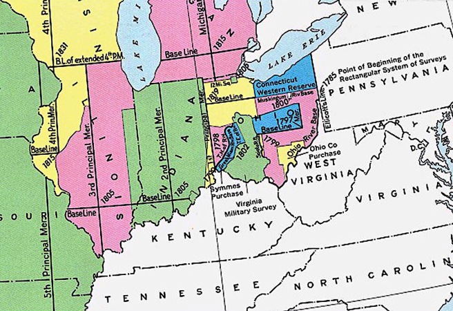
Due to how the state had been originally surveyed starting from the intersection of the Third Principal Meridian and the Centralia East/West baseline, Section 9 that today is bounded by Madison, State, Chicago, and Halsted Streets, was unique in that it is the only section that encompasses all three branches of the Chicago River: the Main Branch, as well as the North and South Branches of the Chicago River that joined at a location commonly referred to as Wolf Point. In other words, the Main Branch of the Chicago River split at this juncture into the South Branch that led to the Des Plaines River, and the North Branch that continued northward for some forty miles. (These three branches created a Y-shaped, three-part division of the city that would be formalized in the City Charter of 1837 as the North, South, and West Divisions, a pattern that would typically pit one area versus the other two, depending upon the politics of a given issue.)

Surveyor James Thompson was hired by the Canal Commissioners to finally extend Illinois’ Cartesian grid into the area at the mouth of the Chicago River, that at the time was said to have been inhabited by Fort Dearborn and some forty people (Galena’s population at this time had already exceeded 10,000), primarily engaged in the fur trade and supplying the local Native people. Thompson had few buildings to contend with:
“The Agency occupied the center of North State street, near the river bank; that of McKee stood at the southwest corner of State and Kinzie, and extended into the present State street; Portier’s cabin was a little southwest of McKee’s and Wolcott’s log house, on the river bank, southwest of Portier’s; John Miller’s cabin fronted on the river, at Wolf Point, between the north branch and the bayou, and Mark Beaubien’s first frame house, on what is now the southeast corner of Lake and Market… J.B. Beaubien’s store, on the west bank of the old river, Fort Dearborn, at the corner of River street and Michigan avenue, Craft’s store and house, on the northwest corner of Madison street, opposite (the) mouth of old river, and the Kinzie house, on the river front, between Rush and Pine streets, were all east of the original plat.”

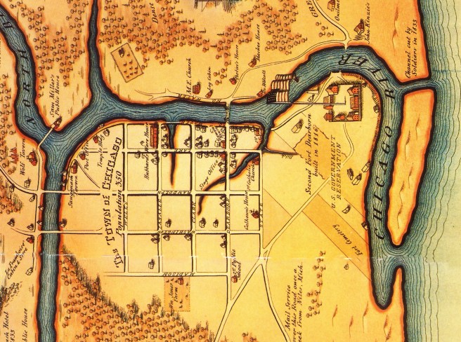
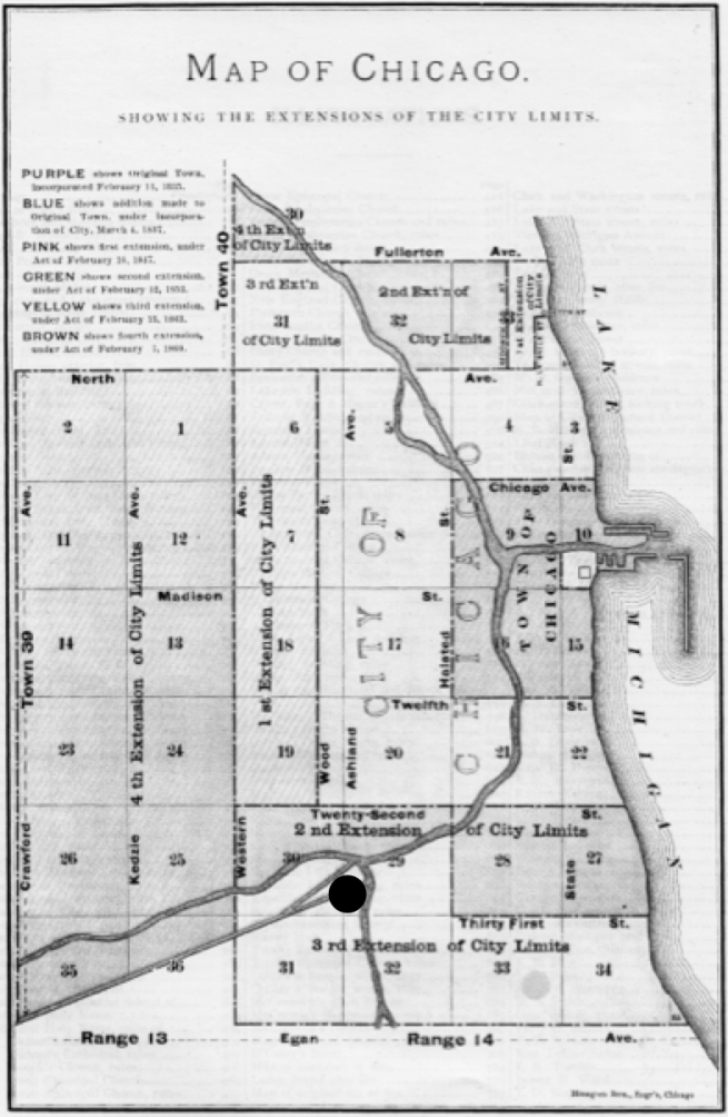
Thompson limited himself to only the areas immediately adjacent to the banks of the river, that is, only the southern half of the section (the section is bordered on the north by Chicago Avenue and on the west by Halsted) stopping at Kinzie and at “Des Pleins” (sic). Respecting the original north-south orientation of the boundaries of the townships and sections established by the Land Ordinance of 1785, he subdivided this portion of the section into a strict rectilinear grid of twelve blocks by twelve blocks, the standard block had dimensions of 320’ (four lots that were 80’ wide) e/w and 360’ n/s (two lots that were 180’ long-minus an 18’ alley) with 80’ wide streets. He assigned names to the streets employing either recent heroes (Washington, Dearborn, Clark) or local features (Lake, Canal, Water).
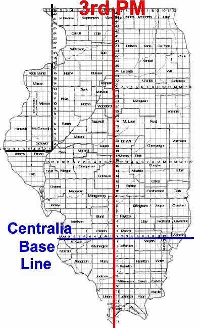
From the portion of Section 9 that he surveyed, one can surmise that Thompson had begun at the Section’s southeast corner and set the future northwest corner of Madison and State at this point: some 233 miles north of the Centralia East/West baseline, located just to the south of Centralia, IL, and 81 miles east of the mouth of the Ohio River into the Mississippi River at Cairo, IL, the position of the Third Principal Meridian. Chicago’s future street pattern was thus rationally imposed by humans within the overall grid of Illinois, with no influence whatsoever from the local natural context, but instead, located so many miles east of the mouth of the Ohio River into the Mississippi, and so many miles north of the arbitrarily imposed east/west baseline.
Following the method of platting a township into sections (as adopted by the General Land Office on May 18, 1796), Thompson consecutively numbered the blocks, starting in the northeast corner (southwest corner of State and Kinzie) and running west, and then dropped one block south and returned eastward, altering the shape and sizes of the blocks only when needed to accommodate the three branches of the river. The section’s eastern boundary was where Thompson had set what was to eventually become State Street, as he had no orders to plat beyond the limits of Section 9. He did not venture across State Street into Section 10, as the Federal government had claimed the lakefront in the southern portion of Section 10 around the fort and it would obviously not be for sale at this time, a fact that would eventually prove to be a blessing for the long-term future of the city’s residents. Thompson formally filed his plat for the “Town of Chicago” on August 4, 1830. As there was no town there at the time, there was also no existing village green or town commons, so typical of New England villages. Thompson would make one last decision that would have a permanent impact on the future city’s overall urban fabric, before he handed the land over to the free market to do with it as it pleased: he arbitrarily established block 39, bounded by La Salle, Washington, Clark, and Randolph, that was somewhat centrally positioned within the area south of the river’s main branch, to be the town’s future Public Square. It would be up to the city leaders in the future to encourage this block to eventually look, feel, and function as a town square.

Unfortunately, the optimism reflected in Thompson’s platting of lots at the mouth of the Chicago River did not induce potential canal lot buyers, for without the finished canal the land had little intrinsic value, and few lots were sold. The ongoing survey of the canal route, finally completed in early 1831, had only compounded the project’s problems. The 96-mile route of the canal was to start at Canalport (29th and Ashland) in Chicago (that would later be known as Bridgeport) and connect with the Illinois River at La Salle, IL, just downriver from the rapids at Starved Rock, where sandbars caused by the Vermillion River emptying into the Illinois prevented any farther navigation upriver. Although the canal route never physically incorporated the Des Plaines River, it did parallel the Des Plaines for the ease of its geologic elevation as well as for the ability to supply the needed water for the canal, especially during dry seasons. Rock, however, was found close to the surface at the Des Plaines River at a point where it had been planned to make a 6’ deep cut to accommodate large vessels with deeper draughts for a continuous-slope route from Lake Michigan. The cost of such excavation was seen to be so prohibitive that the legislature appointed another commission in February 1831 that charged Chief Engineer James M. Bucklin to not only to explore other routes but also to study the feasibility of employing the newly-developing technology of the steam railroad rather than a canal to link the two rivers. Thompson’s surveyed lots along the Chicago River would remain vacant marshland as the state government continued to debate the project during the next two years.
Further reading:
Andreas, Alfred T. History of Chicago, 3 vols. Chicago, 1884-1886. Reprint, New York: Arno Press, 1975.
Holland, Robert A. Chicago in Maps: 1612-2002. New York: Rizzoli, 2005.
(If you have any questions or suggestions, please feel free to eMail me at: thearchitectureprofessor@gmail.com)
