i.6. ARCHITECTURE

John M. Van Odsel, Courthouse Square bounded by Clark, Washington, La Salle, and Randolph (looking north). The additional floor and a larger cupola had been added in 1858. Photograph taken on May 2, 1865, with the Courthouse decorated in mourning following the assassination of Abraham Lincoln. The line of mourners to view Lincoln’s casket flows down the stairs. (Lewis, Remembering Chicago)

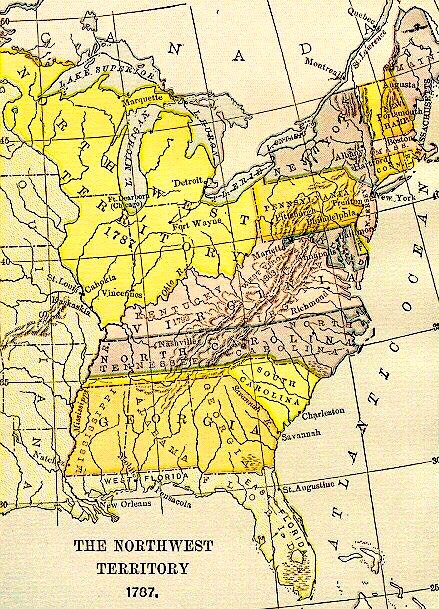
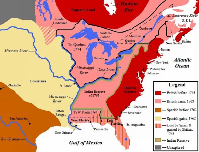
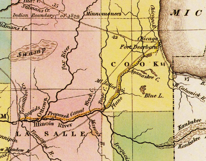
So it was the route of the first transcontinental railroad that finally allowed Chicago to pull to the forefront of Western cities shortly after the 1871 fire.  But what was Chicago’s architecture like just prior to the Great Fire?  Books abound that document the Chicago that arose out of the ashes of the fire.  Some make assumptions of what the pre-fire city looked like or how the fire affected the reconstruction of the post-fire city, but there is no comprehensive study of the Chicago that was actually destroyed or of how the fire subsequently affected construction practices immediately after.  This blog is an attempt not only to do just that, to document the Chicago that burned on October 8, 1871, but to better appreciate how the city’s urban structure had developed by that date: to also record how the city evolved in just 41 years from a virgin marsh within the Illinois prairie when Thompson surveyed it in 1830 into a city of 325,000 inhabitants by 1871.

When one mentions “Chicago architecture,” one cannot avoid the associations it has with three somewhat independent yet interdependent topics: modern architecture, the skyscraper, and the iron skeleton frame.  While these internationally studied topics did not enjoy their first period of maturation until the 1880s, that is obviously beyond the scope of this study’s timeframe (see my other blog documenting the Chicago School – click icon at right), the foundations for the development of all three had been laid prior to October 1871, albeit not, by any means, solely in Chicago.   I will document many of the events, issues, and personalities involved with the development of each of these three topics that occurred throughout the U.S. and Western Europe during the timeframe of this blog, to present a broader picture of how they developed, and ultimately manifested themselves in Chicago’s post-fire architecture.

Left: John Mills Van Osdel (1811-91); Right: W. W. Buffington (1818-98)

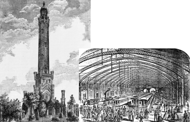
While the work of Chicago’s first architect, John Mills Van Osdel, has been well documented and he has been celebrated as having been the city’s leading architect prior to the 1871 fire, there are three other major figures in the history of Chicago’s architecture during this era whose seminal importance have not been fully documented.  William Warren Boyington, an experienced professional from Massachusetts who moved to Chicago in 1853, is one of these whose impact on the city’s fabric and skyline has been grossly marginalized simply because he produced the great majority of his many and monumental buildings during the period prior to 1885 when eclecticism was not only the fashionable style of architecture, but also the style so despised by the historians of early modern architecture, so that his creative output was simply ignored due to ideological indifference.   I argue that Boyington had drawn equal to, if not surpassed Van Osdel’s practice and reputation by the time of the fire, a position he held for the next fifteen years, until Burnham & Root simply snatched the baton from Boyington’s slowing, but still steady hands in 1885.  Over the course of more than forty years of practice in Chicago, Boyington was responsible for such record buildings as the city’s two tallest structures, the Chicago Water Tower and the post-fire 303’ Board of Trade at the foot of La Salle and Jackson Streets (that at the time was the tallest building in the U.S.), as well as Chicago’s two longest spanned spaces, the La Salle Street Station with its trainshed (then the longest span in the U.S.) and the post-fire Interstate Exposition Building.

W.W. Boyington, Left: Water Tower, 1868. (Andreas, History of Chicago); Right: La Salle Street Station Trainshed. The wood and iron trusses clearspanned the 160′ wide space, that was 542′ long. (Douglas, Rail City: Chicago USA)

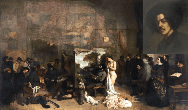
While Van Osdel’s and Boyington’s work represented the prevailing eclectic tendencies of antebellum American architects, two architects settled in Chicago after the end of the war who brought with them detailed knowledge of and were proponents of those European theorists who were arguing for a new, modern style of architecture, one that was derived not from the past but of the present nineteenth century. William Le Baron Jenney, who arrived in 1867, was the second American-born architect, (after Richard Morris Hunt had graduated from Paris’ École des beaux-arts in 1855), to have graduated from an architecture program in France (H.H. Richardson did not attend the École des beaux-arts until 1861).  Jenney, after completing his studies (today one would say that his major was engineering with a minor in architecture) in 1856 at Paris’ École Centrale des arts et manufactures, had spent his “coming into manhood” years in Paris during the start of France’s Second Empire. He had fallen in with a small group of bohemian Americans that included the twenty-five-year-old painter James McNeil Whistler, who traveled in a circle that was unofficially led by the avant-garde painter Gustave Courbet.  

Left: William Le Baron Jenney (1832-1907); Peter Bonnett Wight (1838-1925)

This experience obviously had expanded Jenney’s insights into art, as well as life itself, and Jenney himself attributed this period as the influence for his expansion beyond engineering to include architecture. But before he could find employment in the profession back in the U.S., he joined the Union Army at the start of the Civil War, serving on the engineering staffs of first Grant, and then Sherman.  His skill set, therefore, included both ends of the spectrum of the profession of architecture: art and science.  Being fluent in French, Jenney was also current with such theorists as Eugène Emmanuel Viollet-le-Duc, in addition to the British writers Owen Jones, Augustus Welby Pugin, John Ruskin, James Fergusson, and Edward Lacy Garbett.  His most important contribution during the period of this study was his 1869 book, Principles and Practices of Architecture, that appears to have been an attempt by him to introduce his fellow Chicago architects to the history of western architecture as well as the principles and nuances of European modern architectural theory.

Gustave Courbet, The Artist’s Studio, 1855, Musée d’Orsay. Upper Right: James McNeill Whistler, Portrait of Whistler with Hat, 1858, Freer Gallery of Art. Both were painted when Jenney was in their group. (Online)

The second, and maybe most important architect to move to post-war Chicago was New York architect Peter Bonnett Wight, who had been captivated with architecture as a student at New York’s Free Academy (from which he graduated in 1856) with his first exposure to Jacob Wrey Mould’s (a former draftsman for Owen Jones) All Soul’s Church in New York.  Wight had been at the forefront of the American followers in New York of the British Design Reform movement since his competition entry was chosen in early 1861 as the winner for the new National Academy of Art, the building in America that best represented the ideas of Ruskin at this time.  

In 1864, while Jenney was still marching with Sherman in Georgia, Wight was a founding member of the Association for the Advancement of Truth in Art in New York, a group modeled after the English “anti-academic” Pre-Raphaelite Brotherhood, but in reality was dedicated more to the teachings of Ruskin.  (As Jenney was connected with French “modern” painters, so Wight was following English “modern” artists.)

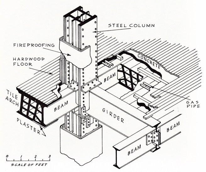
Wight had then joined the American Institute of Architects in 1866 and during this period had expanded his expertise into the area of fire-resistant construction in buildings.  Similar to Jenney, Wight was also well versed in art as well as in science.  Following the 1871 fire, Wight would be invited by Asher Carter and William Drake to join their Chicago firm to assist in the rebuilding of the city.  He did so, and even more importantly for the future of Chicago’s architecture, also brought a young architect, John Wellborn Root with him to supervise the firm’s drafting room.  Wight will be the first to bring the theoretical ideas of Jones to Chicago that complemented his own writings during the 1870s.  Most importantly, however, Wight will also be responsible for inventing and developing the technical means of fireproofing structural iron with porous terra cotta casings that was to be the basis of what was to be known at the time as “Chicago construction.” 

“Chicago Construction,” Iron skeleton-framing protected by a casing of terra-cotta. (Online)

If you have any questions or suggestions, please feel free to eMail me at: thearchitectureprofessor@gmail.com)

i.3. THE NORTHWEST

(A note: I am still working out the bugs in this new blog: please eMail me whether or not you received an eMail from WordPress that I had posted this? Thanks!)

The term “the Northwest” in American geography can be sometimes confusing.  Currently the usage of “the Northwest” is interchangeable with the term, “the Pacific Northwest.”  Historically, however, before this portion of the North American continent came under the sole jurisdiction of the United States with the 1846 Oregon Treaty, it was initially referred to by Americans as “the Oregon Country” or “the Oregon Territory.”  Before the United States consummated the Louisiana Purchase in 1803, the legal western boundary of the United States had been the eastern bank of the Mississippi River, therefore, it was geopolitically accurate to use the term, “the Northwest,” (such as the U.S. 1787 North-West Ordinance) in reference to the area that would eventually encompass the states of Ohio, Michigan, Indiana, Illinois, and Wisconsin, as it lay north of the Ohio River and west of Pennsylvania.  (Hence, the origin of the name of Northwestern University.) 

Map of the United States and the Northwest Territory, 1787. Note that the original proposed border between Illinois and Wisconsin is mistakenly located at its final location. (Online)

However, as the American population and the borders of the U.S. continued to move ever westward, it became anachronistic to refer to this area as “the Northwest,” with the term, “the Midwest” becoming the commonly accepted term for this area.  Historians have since adopted the term, “the Old Northwest” when writing about this region.  However, I find this term to be anachronistic for my purposes because it was not it use during the time this blog covers.  While the original document of the 1787 Ordinance spelled the term with a hyphen, i.e., North-West, I found this spelling personally somewhat clumsy.  I finally settled upon the spelling, NorthWest, because I consider it to be poignant because this is how it was spelled in the logo for William Ogden’s Chicago & NorthWestern Railway, the railroad responsible for much of Chicago’s early greatness. (I believe he chose this spelling to specifically identify his railroad with both the free North, as opposed to the slave South, and the new West, as opposed to old East).

The logo for the Chicago & NorthWestern Railway. (Online)

i.4. THE GEOPOLITICS OF THE NORTHWEST

On July 13, 1787, the Continental Congress meeting in Philadelphia passed the North-West Ordinance, establishing a process to organize the over 260,000 square miles of virgin territory that lay north of the Ohio River, west of Pennsylvania, and east of the Mississippi River.  The NorthWest, blessed with a number of natural waterways, including four of the five Great Lakes, fertile plains, large stands of old forest trees, and unknown minerals waiting to be discovered, caused post-Revolutionary speculators to drool over the potential profits to be had once the Federal government opened up the land in this region for sale.  As the NorthWest amassed occupants and systems of transportation, with businesses correspondingly materializing, towns and, eventually, cities would rise, and sometimes decline, within the natural cycle of the capitalist economy, all competing to be the economic and population capital of the region.   Detroit, founded by the French in 1701 on the Detroit River that linked Lake Erie with Lake Huron, was in 1764 still the largest town, with 800 occupants, between British Quebec and Spanish New Orleans (founded 1718) when St. Louis was founded by French fur traders at the juncture of the Mississippi and Missouri Rivers.  They had initially used the east bank of the Mississippi in this area as a jumping-off location to expand the fur trade into the western hinterland along the Missouri, but following the signing of the 1763 Treaty of Paris that ended the Seven Years’ War and put the east bank of the Mississippi River under British control, these traders had simply relocated to the west bank that the French had ceded to the Spanish prior to the end of the war.  Therefore, St. Louis and the west bank of the Mississippi lay in Spanish-controlled territory, just outside of the American jurisdiction under the North-West Ordinance, and therefore, would play only a minor part in the early settlement of the NorthWest.  

Map of North American Boundaries after the Seven Years’ War. (Online)

Meanwhile, settlement and development of the trans-Appalachian NorthWest, dependent upon water transportation as it was the easiest and quickest means of moving goods and passengers in the pre-railroad era, followed the path of least resistance: the Ohio River from the East that flowed into the Mississippi.  Therefore, it would be Cincinnati, founded in 1788, within a year from the passage of the 1787 Ordinance, on the north bank of the Ohio, in the middle of the country with equal and easy access to markets in both the North and the South, that would quickly become the early economic, population, and eventually, cultural center of the region, and not St. Louis. Thomas Jefferson’s Louisiana Purchase in 1803 had finally brought St. Louis and New Orleans into the American fold and opened up the Mississippi as a second water route to the NorthWest.

Map of the eastern U.S., showing the Ohio River and Mississippi River routes into the NorthWest. The importance of the potential of an Erie Canal in linking New York, via the Hudson River, to the Great Lakes and that of a canal from Chicago to the Illinois River is evident. (Online)

Geography had determined that these two major highways, the Ohio from the industrial East and the Mississippi from the antebellum South intersected at a point only some 125 miles south of where the Missouri River, the water route to the great western plains, took off from the Mississippi. Therefore, St. Louis, located at the nexus of these three major waterways, naturally grew to become the “Gateway to the West,” and was, therefore, predestined to be the natural portal through which all traffic, from either the Atlantic coast or the Pacific coast, on its way to the other had to pass.  Yet Cincinnati remained the largest, and the most culturally important city in the NorthWest until the end of the Civil War.

James Thompson’s Plat of Township 39, Section 9 (Town of Chicago), August 4, 1830. (Holland, Chicago in Maps)

In 1830, when surveyor James Thompson platted the prairie marshland in Section 12 of Township 68 at the mouth of the Chicago River into Lake Michigan, where Fort Dearborn had been erected in 1803, Cincinnati’s population had grown to 24,831 while St. Louis’ was 5,882. Thompson noted that there were some forty inhabitants in the immediate area of Fort Dearborn, primarily involved with the fur trade with the indigenous native population.  When the town of Chicago was chartered some three years later in August 1833, its population was estimated to have been 350, having slowly grown in anticipation of the sale of the land deeded to the state by the Federal government to pay for the construction of the Illinois & MIchigan Canal, that would link Lake Michigan via the South Branch of the Chicago River to the Illinois River that emptied into the Mississippi only ten miles upriver of St. Louis. Naturally, when completed this canal link between the Great Lakes and the Mississippi would solidify St. Louis’ position as the transportation hub in the West.  With the setback of the economic recession of 1837-1845, however, it would take 15 years to complete the canal, but on April 16, 1848, the first boats made their way up and down the canal.  By this time the city’s (as Chicago had been incorporated in 1837) population had grown to 20,000, while the size of New Orleans and Cincinnati had each grown to over 100,000 and St. Louis’ had reached 70,000.

(If you have any questions or suggestions, please feel free to eMail me at: thearchitectureprofessor@gmail.com)

INTRODUCTION

While Chicago’s post-fire architecture has been rigorously documented and studied for over seventy-five years (including my own blog: The Chicago School of Architecture), no one, to my knowledge has written a comprehensive history of the city’s architecture and urban design that began with Fort Dearborn in 1803 and ended with the 1871 fire.  This is the task that I have undertaken with this blog.  I hope you enjoy my findings.

i.1. “WHY CHICAGO?”

On any given day, hundreds of amateur aficionados of architecture, many from out-of-town, patiently wait at the boat dock of the Chicago Architecture Center at 112 E. Wacker Drive for one of its famous river tours of the city’s buildings to begin.  Many of these folks also have an interest in Chicago’s history as well as in the city’s architecture.  Inevitably the question arises after they have enjoyed some the city’s many delights, “But what makes Chicago’s architecture so special?” or “Why were these buildings erected here, and not in St. Louis or Cincinnati or Milwaukee?” I have written this blog for people such as these to enhance their knowledge and appreciation for the history of Chicago and its notable architecture.   

I began many years ago to research these questions.  My original objective was to document the early history of the city’s skyscrapers, but as I got more involved in my research, I found more questions than answers.  As my research became more focused, one day I was puzzled by the fact that many of the city’s important buildings of the 1880s such as the Portland Block, the Grannis Block, the Monadnock, the Pontiac, and the Marquette were built along Dearborn Street.  In fact, these buildings were all owned by the same developers, Peter and Shepherd Brooks of Boston.  Dearborn was back then, as it still is, terminated by the Dearborn Street Station and so I set off in search of the answer as to whether or not the Brookses’ buildings had any relation to the station?  (The answer was yes: one of their cousins was one of the financiers of the railroads that built the station.) This quest took over a year of researching the history of Chicago’s railroads that opened up further questions that I proceeded to explore, until I decided to write a blog that documented Chicago’s early history, that, of course, included the history of its architecture.

What subjects does the phase “history of Chicago” typically evoke?  In no particular order, these topics I believe would be among the popular choices of many Americans:

 -the “Windy City”

– the Great Fire of 1871

– Machine politics

– Shopping at Marshall Field’s

– the “Loop” and the “Magnificent Mile”

– its Professional sport teams 

– Crime of the Al Capone era 

In addition, those Americans who are informed about the arts and/or history would also most likely identify:

– Architecture, especially that of the skyscraper and Frank Lloyd Wright 

– the Art Institute of Chicago

– the Chicago Symphony Orchestra and the Civic Opera

– Food processing be it grain at the Board of Trade or meatpacking at the long-defunct Union Stockyards

– Railroads, that is, until the era of the freeway and commercial jetliner

– the city’s two World’s Fairs of 1893 and 1933

– the University of Chicago’s renowned programs in Sociology and Economics

As I have set the period for this first blog of Chicago’s history between the erection of the first Fort Dearborn in 1803 and the second Chicago fire on July 14, 1874, only three of the above subjects, sport teams, organized crime, and the two fairs, are not contained within my temporal framework.  In prioritizing these subjects along my interests for the blog, I focused on three and wove them throughout my narrative and at one time considered titling this blog, “Politics, Railroads, and Architecture,” echoing the great British art critic John Ruskin’s tripartite-nature of urban history (St. Mark’s Rest: The History of Venice, 1877), for in Chicago these three forces came together to produce one of the world’s great collections of architectural masterpieces.   

i.2. THE “CITY” OF CHICAGO

James Thompson’s Plat of Township 39, Section 9 (Town of Chicago), August 4, 1830. (Holland, Chicago in Maps)

But before one can erect buildings (architecture) in a city, there must be a city.  That is, before architects can begin to practice their art, politicians, businessmen, and engineers have to lay the groundwork with a physical infrastructure of streets, sidewalks, water distribution and sewage removal, street lighting, and (in the case of Chicago) bridges.  Chicago’s business district surveyed into 64 blocks as initiated by surveyor James Thompson in 1830 started out as primeval prairie marshland(bounded by the lake on the east, the river on the north and the west, and by Van Buren Street, as far north as the city would eventually permit the railroad to penetrate the city’s fabric, on the south).  I originally had also toyed with the idea of using the title, “64 Blocks,” as this story is also the history of how Americans during the latter two-thirds of the nineteenth century used these 64 blocks for their own purposes to evolve the urban fabric of streets, sidewalks, buildings, and open spaces for the Euro-American city of over one million residents known as “Chicago,” that by 1900 had become the economic center of the trans-Appalachian western half of the country. 

And “used,” with minimum, if any, government intervention, is the operative term for the laissez-faire attitude of Americans towards their government in the nineteenth century.  But while this hand’s-off attitude of government’s responsibility applied only to its ability to control what a private citizen could do with “their” property, it by no means applied to what a particular elected representative, or group thereof, could accomplish in the way of graft, patronage, or what was commonly referred during this period as “boodle.”  Boodle would be plentiful in Chicago, especially for those who had, to use a particularly Chicago term, “clout.”  Free market capitalism was the rule of the day in the nineteenth century, and it applied to private business as much as it did to representative government.  Everything had a price, what today we call “commodification,” and no city better than Chicago represented the nineteenth century commodification of everything, for Chicago would even invent the “commodities market.”   Anything and everything (including eventually the sky) would be “for sale” in Chicago.

Those 64 blocks of virgin prairie represented the ultimate commodity: free land whose ownership would go to the highest bidder. Thomas Jefferson had planned for the orderly distribution of this commodity (taken, of course from its indigenous inhabitants) in the Land Ordinance of 1785 by applying Rationalism, then the dominant philosophy near the end of the Enlightenment or the “Age of Reason,” to solve the problem: the French philosopher René Descartes’ rectilinear grid was extended over nature’s tabula rasa (a blank slate) of the prairie of the NorthWest (see illustration). Man was, so characteristically for the era, exerting his dominance over nature.  Nineteenth century technology would allow him to do this, and nowhere better than in Chicago was this attitude made more manifest.  The city’s unofficial motto, “I will,” reflects the city’s tradition that from its founding, has been one of overpowering anything and everything that stood in its way, including nature itself.  This attitude had at its foundation, a positivist belief that mankind can overcome nature at any point with the use of its technology. 

1833 Map by H.S. Tanner Showing the Route (dashed line) of the Canal. Note the portage between the Chicago River and the Des Plaines River, where Mud Lake has been drawn along the southern edge of the portage. The canal parallels but does not conjoin the Des Plaines River. It joins the Illinois River just below the “Rapids” at Starved Rock. (Ranney, Prairie Passage)

As we shall see, Chicago was a completely artificial or man-made city, in a location that nature had not necessarily predestined for human habitation, very much like Venice or the Netherlands.  This was eventually proved by the fact that the reason for its original existence, a port on Lake Michigan that could be connected to the Mississippi River, was eventually better served with the construction of another port where Chicago should have been built in the first place, at the southern tip of Lake Michigan at the mouth of the Calumet River.  While its geographic location at the mouth of the Chicago River that emptied into Lake Michigan made its location “desirable” from a transportation standpoint, these same topographic features made the immediate area relatively unoccupiable.  Ground water was so close to the surface that privy holes could not be dug but had to built up from the ground.  There was so little elevational slope to the terrain that rain, snowmelt and sewage did not drain anywhere, but simply stayed where it fell.  Because the local soil structure included a shallow layer of impervious clay, only so much water could be absorbed before the roads turned into rivers of knee-deep septic mud.  As the city began to grow, the municipal authorities responded to the sewage problem by building a system of primitive surface sewers that diverted the city’s sewage to the main branch of the river.  Unfortunately, the river flowed into Lake Michigan, the source of the city’s fresh water, where the lake’s current frequently pushed the effluent south, past the city’s first freshwater intake, initiating a vicious and unhealthy cycle that encouraged the mass diseases of cholera and typhoid.  The city had little choice but to eventually raise the elevation of the entire downtown, one building at a time, in as much as 15’ in some places, in order to install a viable sewer system above the original ground level with sufficient slope to the river.

To overcome the problem Chicago had in obtaining fresh water, the city first attempted to, and succeeded in building the longest manmade tunnel to date, under the bed of the lake as its freshwater intake, thought to be far enough away from the mouth of the river with the hope that the distance would purify the water.  When this proved ineffective in times of heavy rains and spring thaws, the city resorted to the ultimate application of human technology to solve a “natural” problem: it reversed the direction of the flow of the river, itself.  Therefore, without the engineering prowess of such men as William Ogden, William McAlpine, Ellis Chesbrough and Octave Chaute, Chicago would have been left in the mud drinking its own sewage for a much longer time than it did.  Therefore, there could have been little, if any architecture in Chicago if it hadn’t been for the inventiveness of the city’s engineers. While the city celebrates its long history of architects, Chicago’s great engineers are the city’s unsung heroes and merit having their story told along side that of its architects.

A city also must have an economic infrastructure in place not only to generate the funds to pay for these civic necessities but also to be able to build architecture, because it is, after all, one of the more complex (politics) and the most expensive (money) of the arts undertaken by humans.  With architecture we are immediately confronted with the reality that it takes a minimum of three people to design and build a building (with the exception, of course, of an architect’s own house): the architect and the person who will pay both the architect to design the building and the contractor to erect the building. This is not necessarily the case with a poem that can be written by a single person, or with a painting by an artist who can purchase a canvas and apply paint to it without any direction or resources from anyone else, or a musical composition written by a person who can sit down at a piano’s keyboard and compose a piano sonata.  These activities can all be done by a lone individual, who, once finished, can leave the finished work for posterity to do with it as it may please.

Not so with an architect.  While he or she can sit at his board (or now computer) and draw a building just as easily as the painter can do a painting, the result is not a piece of architecture: it is a drawing, but it is not, by any means, a building.  For a drawing to become architecture, a real physical object that people can look at, touch, and walk through, it must be made into a three-dimensional object, a building.  And of course, this costs a great deal of money that someone must provide. The infant town of Chicago needed men of great vision and business acumen to create a viable urban economy that eventually could embark on the creation of architecture, and to have a strong urban economy in the nineteenth century, an American city had to know how to “play to win” in the national political arena.  Two of the most important political contests during this period in American politics that would be central to the “I will” city’s ascension as the largest and most powerful city in the West would be the route of the first transcontinental railroad and the Civil War.

(If you have any questions or suggestions, please feel free to eMail me at: thearchitectureprofessor@gmail.com)