
(A note: I am still working out the bugs in this new blog: please eMail me whether or not you received an eMail from WordPress that I had posted this? Thanks!)
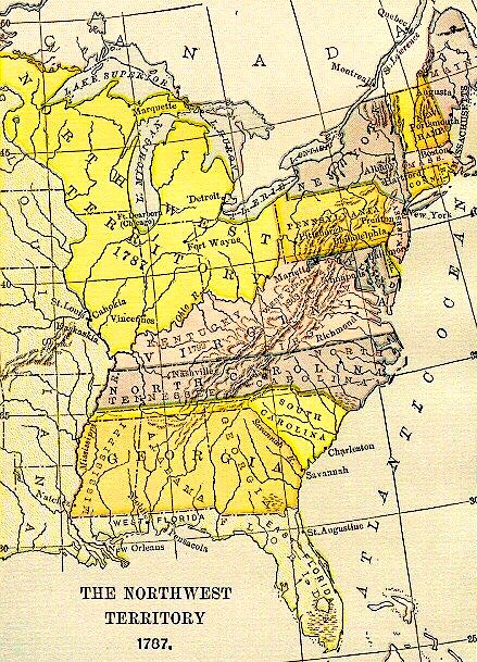
The term “the Northwest” in American geography can be sometimes confusing. Currently the usage of “the Northwest” is interchangeable with the term, “the Pacific Northwest.” Historically, however, before this portion of the North American continent came under the sole jurisdiction of the United States with the 1846 Oregon Treaty, it was initially referred to by Americans as “the Oregon Country” or “the Oregon Territory.” Before the United States consummated the Louisiana Purchase in 1803, the legal western boundary of the United States had been the eastern bank of the Mississippi River, therefore, it was geopolitically accurate to use the term, “the Northwest,” (such as the U.S. 1787 North-West Ordinance) in reference to the area that would eventually encompass the states of Ohio, Michigan, Indiana, Illinois, and Wisconsin, as it lay north of the Ohio River and west of Pennsylvania. (Hence, the origin of the name of Northwestern University.)
However, as the American population and the borders of the U.S. continued to move ever westward, it became anachronistic to refer to this area as “the Northwest,” with the term, “the Midwest” becoming the commonly accepted term for this area. Historians have since adopted the term, “the Old Northwest” when writing about this region. However, I find this term to be anachronistic for my purposes because it was not it use during the time this blog covers. While the original document of the 1787 Ordinance spelled the term with a hyphen, i.e., North-West, I found this spelling personally somewhat clumsy. I finally settled upon the spelling, NorthWest, because I consider it to be poignant because this is how it was spelled in the logo for William Ogden’s Chicago & NorthWestern Railway, the railroad responsible for much of Chicago’s early greatness. (I believe he chose this spelling to specifically identify his railroad with both the free North, as opposed to the slave South, and the new West, as opposed to old East).
i.4. THE GEOPOLITICS OF THE NORTHWEST
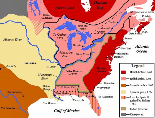
On July 13, 1787, the Continental Congress meeting in Philadelphia passed the North-West Ordinance, establishing a process to organize the over 260,000 square miles of virgin territory that lay north of the Ohio River, west of Pennsylvania, and east of the Mississippi River. The NorthWest, blessed with a number of natural waterways, including four of the five Great Lakes, fertile plains, large stands of old forest trees, and unknown minerals waiting to be discovered, caused post-Revolutionary speculators to drool over the potential profits to be had once the Federal government opened up the land in this region for sale. As the NorthWest amassed occupants and systems of transportation, with businesses correspondingly materializing, towns and, eventually, cities would rise, and sometimes decline, within the natural cycle of the capitalist economy, all competing to be the economic and population capital of the region. Detroit, founded by the French in 1701 on the Detroit River that linked Lake Erie with Lake Huron, was in 1764 still the largest town, with 800 occupants, between British Quebec and Spanish New Orleans (founded 1718) when St. Louis was founded by French fur traders at the juncture of the Mississippi and Missouri Rivers. They had initially used the east bank of the Mississippi in this area as a jumping-off location to expand the fur trade into the western hinterland along the Missouri, but following the signing of the 1763 Treaty of Paris that ended the Seven Years’ War and put the east bank of the Mississippi River under British control, these traders had simply relocated to the west bank that the French had ceded to the Spanish prior to the end of the war. Therefore, St. Louis and the west bank of the Mississippi lay in Spanish-controlled territory, just outside of the American jurisdiction under the North-West Ordinance, and therefore, would play only a minor part in the early settlement of the NorthWest.
Meanwhile, settlement and development of the trans-Appalachian NorthWest, dependent upon water transportation as it was the easiest and quickest means of moving goods and passengers in the pre-railroad era, followed the path of least resistance: the Ohio River from the East that flowed into the Mississippi. Therefore, it would be Cincinnati, founded in 1788, within a year from the passage of the 1787 Ordinance, on the north bank of the Ohio, in the middle of the country with equal and easy access to markets in both the North and the South, that would quickly become the early economic, population, and eventually, cultural center of the region, and not St. Louis. Thomas Jefferson’s Louisiana Purchase in 1803 had finally brought St. Louis and New Orleans into the American fold and opened up the Mississippi as a second water route to the NorthWest.

Geography had determined that these two major highways, the Ohio from the industrial East and the Mississippi from the antebellum South intersected at a point only some 125 miles south of where the Missouri River, the water route to the great western plains, took off from the Mississippi. Therefore, St. Louis, located at the nexus of these three major waterways, naturally grew to become the “Gateway to the West,” and was, therefore, predestined to be the natural portal through which all traffic, from either the Atlantic coast or the Pacific coast, on its way to the other had to pass. Yet Cincinnati remained the largest, and the most culturally important city in the NorthWest until the end of the Civil War.

In 1830, when surveyor James Thompson platted the prairie marshland in Section 12 of Township 68 at the mouth of the Chicago River into Lake Michigan, where Fort Dearborn had been erected in 1803, Cincinnati’s population had grown to 24,831 while St. Louis’ was 5,882. Thompson noted that there were some forty inhabitants in the immediate area of Fort Dearborn, primarily involved with the fur trade with the indigenous native population. When the town of Chicago was chartered some three years later in August 1833, its population was estimated to have been 350, having slowly grown in anticipation of the sale of the land deeded to the state by the Federal government to pay for the construction of the Illinois & MIchigan Canal, that would link Lake Michigan via the South Branch of the Chicago River to the Illinois River that emptied into the Mississippi only ten miles upriver of St. Louis. Naturally, when completed this canal link between the Great Lakes and the Mississippi would solidify St. Louis’ position as the transportation hub in the West. With the setback of the economic recession of 1837-1845, however, it would take 15 years to complete the canal, but on April 16, 1848, the first boats made their way up and down the canal. By this time the city’s (as Chicago had been incorporated in 1837) population had grown to 20,000, while the size of New Orleans and Cincinnati had each grown to over 100,000 and St. Louis’ had reached 70,000.
(If you have any questions or suggestions, please feel free to eMail me at: thearchitectureprofessor@gmail.com)
