
The construction of the Illinois-Michigan Canal at the Chicago River was supported by the majority of St. Louis’ civic leaders, for it would link Lake Michigan to the Illinois River, that emptied into the Mississippi only fifteen miles upriver from the mouth of the Missouri River and would give St. Louis a direct water route to the Great Lakes, and with the anticipated completion the Erie Canal, a second route to the Atlantic Ocean. The Chicago canal, in conjunction with the anticipated completed National Highway to Washington, therefore, would cement St. Louis’ centrality in the West as nature had seemingly blessed its location not only at the confluence of the Mississippi, the Missouri, and the Illinois Rivers, but also only some 150 miles upriver from where the Ohio River joined the Mississippi, which placed the city at the nexus of four of the country’s then larger river basins. After Cincinnati, St. Louis was the largest city in the West (of course, New Orleans in the South was still the largest west of the Appalachians), and indeed, it was where explorers and fur traders who wanted to travel west of the Mississippi River either up the Missouri River to Oregon or along the Santa Fe Trail to the southwest usually started their journey.

The future of St. Louis as the commercial hub of the trans-Mississippi basin was quite self-evident to the geologist and self-appointed researcher of Native Americans, Henry Schoolcraft, who travelled through St. Louis in early 1819, and recorded that the city would be “the future seat of empire for the vast basin of land, situated between the Alleghany [sic] and the Rocky Mountains on the east and west, and between the northern Lakes and the Gulph [sic] of Mexico on the north and south… no place in the world, situated so far from the ocean, can at all compare with its for commercial advantages.” Thomas Hart Benton, a relative newcomer to the city, wholeheartedly agreed with Schoolcraft’s observation. Benton, originally from North Carolina where he had been dismissed from the University of North Carolina for stealing money from fellow students, had moved to escape the scandal to Tennessee, where he soon became the protégé of Gen. Andrew Jackson, being named his aide-de-camp at the start of the War of 1812. A personal disagreement with his mentor in 1813, however, resulted in a gunfight in which Benton’s brother had shot Jackson in the arm that ended the relationship. With the end of the war, once again to avoid the consequences of his actions, Benton had moved even farther west to reinvent himself, this time to the thriving city of St. Louis in the fall of 1815, where he managed to set himself up as the Editor of the local Democratic newspaper, the St. Louis Enquirer, that gave him a platform for his Jacksonian ideals and for Missouri statehood.
In June 1819, following Schoolcraft’s visit, Benton published an editorial in which he summarized his plans for his adopted hometown, in which he had envisioned St. Louis as the hub of a western system of radiating waterways and national roads. To augment the region’s natural waterways, he had proposed that the Federal government extend the National Road to carry mail from Washington, D.C., to St. Louis (the National Road had been completed to Wheeling only the year before, and, indeed, Congress approved the extension on May 15 of the following year). His plan also included a second post road (which Congress did have the authority to fund) from St. Louis to Louisville, by way of Vincennes, IN, (located on the Wabash River and the oldest and largest town in Indiana at the time) and a third post road from St. Louis to New Orleans. He also stated that St. Louis should be made a Federal port of entry with its own customs house, in anticipation of the construction of the Chicago canal, and also wanted the government to build a canal to link the Mississippi River with Lake Superior. Thereby, St. Louis would become the transportation center of the country through which all traffic from the East and South would naturally flow on its way to the West and on to the Pacific. And he meant not just to the Pacific, but all the way to China. He meant to break the monopoly of the China ocean trade then held by New England’s shipping merchants with this overland route so that St. Louis’ “small capitalists” might share in the bounty of the Oriental trade.
There was still one hurdle confronting these plans of St. Louis’ new champion, however, Missouri was not yet a state. Louisiana had been the first state located in the Louisiana Purchase to achieve statehood in 1812. Prior to the Purchase, both Spain and France had permitted slavery in the region, so Louisiana entered as a slave state. The area around St. Louis was conducive to the growing of hemp, so Southern planters had settled in the area with their slaves, imparting a slave culture to Missouri, predisposing it to being admitted as a slave state. Debate in the House on the issue began innocently enough on Feb. 13, 1819, until Rep. James Tallmadge, Jr, of New York, who had been Gov. George Clinton’s secretary and was aligned with DeWitt Clinton’s Democratic-Republican faction, stood up and “tossed a bombshell into the Era of Good Feelings” by proposing an amendment that, for all practical purposes, would have prohibited the extension of slavery into the proposed state, that also reignited the bitter split of the young nation into its two completing Sectional ideologies. Speaker Clay, working with Sen. Daniel Webster of Massachusetts and Sen, John C. Calhoun of South Carolina, eventually was able to hammer out what is known as the Missouri Compromise of May 8, 1820, where Missouri was admitted as a slave state, that was offset with the admission of Maine as a free state, with the caveat added by Illinois’ first term Sen. Jesse B. Thomas, that all remaining territory in the Territory north of Missouri’s southern border at the 36° 30’ parallel would remain free of slavery, while nothing was stated about the territory south of the parallel, (truthfully, only a small portion of the Louisiana Territory was located south of the line).
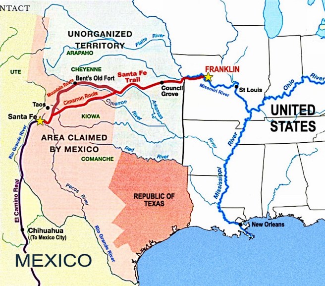
The following year, St. Louis’s prospects improved all the more when Mexico won its independence from Spain in 1821. Much of St. Louis’ initial wealth had been the result of the fur/silver trade with Santa Fe. Although the area’s traders had initiated a thriving trade with Santa Fe back in 1739, for which they had eventually been granted a monopoly by the Spanish colonial government, that brought to the city hard currency or specie, i.e., silver, of which the west was always in need, the 1803 Louisiana Purchase changed the political landscape with the Spanish colonial authorities shutting down all trade with the Americans. However, in September 1821, William Becknell, a businessman from Franklin, MO, (located in the middle of the state) who had spent much of his capital in an unsuccessful bid for political office and needing a solution to his financial predicament, had taken a trading party loaded with goods that included calico and cotton cloth, on pack mules hoping to reach Santa Fe where he might dispose of these at a handsome profit. The timing of Becknell’s trip could not have been better for unbeknowst to him, Mexico had declared its independence from Spain on September 24, 1821. Becknell arrived in Santa Fe in mid-November to the open arms of its citizens, who offered their silver coins for his goods. He returned the following year along a slightly different route that he had to modify to accommodate the wagons he now used, thus establishing the route of the Santa Fe Trail, along which wealthy Santa Fe merchants imported American-made goods in exchange for furs and silver, the hard currency or specie so much in demand throughout the U.S. (The silver thus gained by the U.S. had amounted to over $8.3 million by 1836.)
Becknell’s good fortune in 1821 was mirrored by Benton who, following Clay’s Missouri Compromise of 1820 in which Missouri was made a state, was elected to be one of the new state’s U.S. Senators, where he would champion the growth of the West, and defend the interests of his adopted hometown for the next thirty years, the first U.S. Senator to serve five consecutive terms. His first piece of legislation called for the Federal government to construct a road along the Santa Fe Trail. On March 3, 1825, Congress approved a westward extension of the planned National Road from St. Louis to Jefferson City, the newly named state capital located midway along the Missouri River between St. Louis and Independence (therefore, being located astride both what would eventually be known as the Santa Fe and the Oregon Trails) that was one of the last bills signed into law by Pres. James Monroe. (The Road’s construction would fitfully continue until the Panic of 1837 halted the Federal funding of its construction at Vandalia, IL, then the state capital, some 60 miles short of St. Louis.) Monroe had been much more sympathetic to using Federal funds for internal improvements than had been his predecessors, probably having developed a better appreciation for the need to link the new states west of the Appalachians to the Atlantic Coast. On April 30, 1824, with the successful completion of the Erie Canal in the North on the horizon, he had also signed a bill that provided funding for the necessary surveys to construct the Chesapeake & Ohio Canal in the country’s mid-section that was planned in the short term to link Baltimore to the start of the National Road at Cumberland, and in the long term, to the Ohio River at Pittsburgh.
(If you have any questions or suggestions, please feel free to eMail me at: thearchitectureprofessor@gmail.com)
