
The recession of 1837-45 had slowed the construction of the Illinois & Michigan canal as well as economic migration in the West that allowed Cincinnati to maintain its central position as the largest city in the NorthWest. St. Louis, however, due to its natural geographic advantages was destined to eventually overtake Cincinnati as the country continued to grow ever westward, and it finally celebrated, along with Chicago, the completion of the canal in 1848. It was at this precise moment, however, that the technology of the nineteenth century had coalesced to produce the railroad that gave humans the power to overcome the nature-made advantages as well as the limits of geography. Therefore, the western city that would win this new competition set into motion by the introduction of the railroad into the American landscape, would dictate the resulting growth in the region. The most important political decision that would determine which western city would come out of top was where would the first transcontinental railroad be located, for over this route would eventually flow the vast majority of goods and people between the Atlantic and Pacific Oceans. In essence, the winner would become the capital of the interior of the United States, that is, the political, economic, and cultural center between the Atlantic and Pacific coasts.
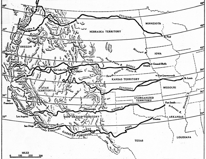
The antebellum transcontinental railroad could have, and probably should have been built, for any number of reasons on a route that paralleled the Mason-Dixon Line from Baltimore to Cincinnati to St. Louis and westward (a second “Missouri Compromise,” if you will), that would have assured St. Louis’s future as the capital of the West. The smaller cities of Chicago in the north and Memphis in the south would eventually have been connected via branch lines to this trunk line. But antebellum Sectional jealousies in Congress as well as Luddite-like responses by some to the threat posed by this new-fangled technology to existing investments and businesses, especially those of the river steamboat industry, protracted the Federal decision on the transcontinental railroad for over two decades, until the start of the Civil War removed Southern obstructionists from the decision process while imposing a crisis upon the Northern Congress that forced it to finally make a decision. A decision that was not to the advantage of Cincinnati and St. Louis, for the competition would eventually be won by Chicago, not through any preordained geographic advantage, but through the hard-fought efforts of its citizens and those who had financial investments in the outcome of the competition, and with a little help from history. Hindsight reveals that every antebellum setback to the start of the construction of a compromise transcontinental route through the country’s midsection (i.e., Washington, D.C., Cincinnati, and St. Louis) prior to 1856 (the completion of the Illinois Central) was another victory for Chicago in its campaign to eventually become the dominant city in the West. To the credit of Chicago’s leading patrician, William Ogden, and Illinois’ Senator Stephen A. Douglas, the actual route of the first transcontinental railroad would eventually be located some 200 miles north of St. Louis to Chicago, making Chicago, and not St. Louis, the eventual nexus of the West’s water and railroad systems. (One could say that Congress’ decision actually reversed the “strategic” flow of the Chicago River some six years before the city reversed its actually flow.)

For it was in 1848, the same year in which the canal was completed, that Ogden started construction of Chicago’s first railroad, the Galena & Chicago Union, headed not to the east to link up with the routes being built to the West but to the west to his ultimate objective, the Pacific Ocean. (I believe that historians have underestimated the importance of Ogden’s unilateral decision:: there were no railroads to Chicago in 1848, period. Ogden started his without any assurances that an Eastern railroad would build to Chicago.) He had gambled that the eastern railroads would want to lay tracks north to Chicago once they reached the southern tip of Lake Michigan to connect with his track, rather than simply laying tracks from the mouth of the Calumet River, some thirty miles to the south of the village of Chicago, west straight to Rock Island on the Mississippi. It would be more than three long years after Ogden had started laying tracks, however, before the first railroad from the Atlantic coast finally made a connection to Chicago in late 1851. But once Chicago was connected to the East coast, it then took only five more years to lay the world’s largest railroad network with Chicago as its hub, with some 58 passenger trains and 38 freight trains arriving/departing daily in 1856 along a network with over 3000 miles of track. Chicago’s population had expanded to 86,000 by this date, making it the fourth largest city west of the Allegheny Mountains (then New Orleans was still the largest with 140,000, Cincinnati was second with 135,000 and St. Louis was third with 90,000). All three Northern cities continued to gain in population during the Civil War, but after Congress finally decided in 1862 that the Union Pacific should start in Omaha, NE, in a direct line with Chicago, Chicago’s population grew the fastest, finally surpassing Cincinnati’s in 1868. Meanwhile St. Louis had already surpassed Cincinnati during the war to become the largest city in the West, a title it held until Chicago’s population finally surpassed St. Louis’, but this didn’t occur until after the transcontinental railroad was completed in 1869 and was in operation for a number of years.
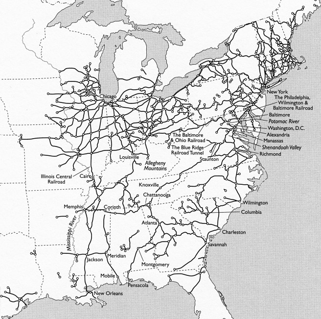
Railroad construction in Chicago from its inception in 1848 to the 1871 fire was primarily financed not by Chicago capital (there was precious little of that during the city’s infancy), but first by East Coast and European venture capital and then with the infusion of Federal funding through landgrants such as that secured by Sen. Douglas’ tireless campaign to build the Illinois Central Railroad. Railroads not only directly affected the physical structure of the city, especially in regard to the location of the required stations, but also indirectly influenced how the city grew, as developers sought to erect their buildings within the close physical proximity to these new urban activity centers. Therefore, in order to truly understand and appreciate the accomplishment of the construction of Chicago’s rail network that would lead to its premiere position in the West, as well as the railroads’ impact on the physical development of the city’s business district, one needs to understand who was actually funding the construction of the railroads, as well as why and where these businessmen were building their lines and stations.
(If you have any questions or suggestions, please feel free to eMail me at: thearchitectureprofessor@gmail.com)
