Before the new Courthouse was occupied on February 7, 1853, the Courthouse Square witnessed another disastrous fire. On October 20, 1852, workmen were reshingling the roof of the First Baptist Church. Sparks from a pipe of one of the workers apparently ignited the wooden roof, starting a fire that totally destroyed the church. The next day, however, the congregation voted to build an even larger building on the site, the cornerstone of which was laid on July 4, 1853. Although the architect of the new church is not recorded, the design bore sufficient resemblances to the churches designed by Van Osdel that it could be credited to his hand. The disaster not only gave the Baptists a second chance to regain the title of the city’s tallest steeple (that they had once briefly held in 1845 when the original 112′ steeple was completed), but urbanistically, it also offered the designer the opportunity to design the new building as a symmetric “bookend” to balance the new First Presbyterian Church at the opposite corner of the block, as viewed from the new Courthouse. The new steeple rose six feet higher than that of the Second Presbyterian’s to a height of 170.’ (If Van Osdel was the architect, this design could have been the one he originally produced for the unbuilt Second Presbyterian Church.)
John M. Van Osdel. Left: First Presbyterian Church, Southwest corner of Clark and Washington, 1847; Right: Rebuilt First Baptist Church, Southeast corner of Washington and La Salle, 1853. A view from the Courthouse cupola taken by Hessler in 1858. (Kogan and Wendt, Chicago: A Pictorial History)
The body of the new Baptist building echoed the simple, box-like form of the First Presbyterian Church, including the flat roofed-cornice capped with a parapet wall. Gone was the grand colonnaded portico of the destroyed church, undoubtedly a victim of the need for more interior space on the relatively shallow lot, the freestanding columns being transformed into two-story pilasters. In an apparent attempt to rectify the abrupt placement of the First Presbyterians’ tower, the designer of the Baptists’ facade incorporated a shallow pediment over the center bay, that marked the entry as well as helped to integrate the steeple with its supporting bay with the body of the building. This detail, the shallow pediment supported by pilasters within the center bay of the elevation, bore a striking similarity to Van Osdel’s treatment of the Courthouse, just across the street. This fact, coupled with the other formal resemblances that the new First Baptist Church had with Van Osdel’s other churches, lends credence to the supposition that Van Osdel was the architect of the church, that first opened its doors on November 12, 1853.
FURTHER READING:
Andreas, Alfred T. History of Chicago- vols. 1&2. Chicago, 1884-1886. Reprint, New York: Arno Press, 1975.
Ericsson, Henry L. Sixty Years a Builder: The Autobiography of Henry Ericsson. Chicago: A. Kroch, 1942.
By 1851, Chicago’s boom was approaching full throttle (Ogden’s G&CU was pushing westward and the MC and MS were racing each other to the state line.) Since the Municipal Building/Market Hall had opened in 1848, 10,000 more people had moved to Chicago, increasing its population by 50% to 29,963. In just three short years, the city government had outgrown its new market building. The situation with the new county Courthouse was the same. The recent construction of the monumental new Protestant churches with their towering spires that surrounded the Square had simply dwarfed what had been the city’s first attempts at serious architecture. A movement to build a replacement for the Courthouse had gained momentum toward the end of 1850, with committees from the city and the county entertaining all ideas of what should be done to solve the space problems of both the county and the city, as well as what to do with the Public Square. Eventually two alternatives emerged from the discussions. Those who believed in frugality with public funds championed a plan to sell the Courthouse Square in order to secure the funds needed to build the necessary buildings on less expensive land. Hence, only the cost of one ornate facade would have to be incurred to achieve a monumental image.
John M. Van Osdel, Combined City/County Courthouse, 1851. From a daguerreotype taken by Alexander Hesler on July 4, 1855, showing “Long John” Wentworth giving a speech. The view is from the northwest corner of the Public Square, looking southeast, with the steeples of the “Protestant Church Row” in the background. (Tallmadge, Architecture in Old Chicago)
Chicago’s frugal, profit-oriented citizens were overruled by a group of civic boosters, led by Francis Sherman, then the President of the Cook County Board, who sought to preserve the only public space in the center of the business district, upon which could be erected a truly monumental building, befitting the size of city Chicago was fast becoming (or more aptly phrased, the type of city the boosters had always hoped to make of Chicago). This group favored a more traditional courthouse image: a freestanding, monumental courthouse set within a town’s square, detached from the street on all four sides. By June 1851, Van Osdel had completed a design for each proposal, so that the necessary governmental committees could evaluate the qualities of each in arriving at a decision. By this time, the city had formally agreed to join the county in erecting one building which would solve the space needs for both governments. Committees from both bodies finally settled upon the more expensive, freestanding building, agreeing to fund its construction through a bond issue. The county was to pay 75% of the project’s cost, while the city would fund the remaining 25%.
Courthouse Square and the Washington Street Protestant Church Row, 1857. (Bluestone, Constructing Chicago)
Van Osdel’s design of the new Courthouse Square had placed the new building in the exact center of the block that not only allowed the courthouse to be seen as a three-dimensional object (as opposed to only a two-dimensional wall surface), but also reserved the greater portion of the square’s perimeter as park space, a desperately needed commodity within the all-privately owned business district (with the exception of the lakefront and Dearborn Park). From the description and dimensions given in Andreas, the floor plan can be deduced as follows: the plan appears to have a Classical-inspired symmetry. The Courthouse had a 164′ overall length in the east-west direction, and a 132′ length in the north-south or front-to-back dimension. He established the overall massing of the building with a central 100’ square block from which projected on its East-West axis two wings, the East for the County, the West for the City. Both major rooms in the east and west wings had dimensions of 60′ by 50,’ meaning that these wings projected 32′ beyond the central square. The entrances on the north and south wings, however, extended only 16,’ exactly half the projection of the east and west wings, imparting to the north and south facades a distinct frontal quality, that was reinforced by the flight of monumental stone stairs to the second floor on the north and south faces. The fronts of both entrances as well as the wings were capped by a shallow pediment, a detail that he had been forced to abandon in the cost-conscious design for the First Presbyterian Church, across the Square. To denote the entries on the north and south facades, Van Osdel once again resorted to his favorite entry motif, the Roman triumphal arch, that he extended for two stories into the third floor. The combination of the triumphal arch and the shallow pediment bore a resemblance to Alberti’s Renaissance masterpiece, Sant’ Andrea in Mantua.
Leon Battista Alberti, Sant’ Andrea, Mantua, 1471.
The building contained three floors. In the ground floor (basement) was located the jail, the sheriff’s office, and rooms for the city watch-house and jailer. The second and entry level (or piano nobile), was accessed by the stairs that led directly to a 14′ wide main hall on the second floor that ran the entire length of the building. This floor contained the city’s offices in the north and west wings as well as an armory in the west wing. Van Osdel symbolically elevated the Common Council room and the courtroom to the top floor of their respective wing. (There is a sound structural reason for locating a large, column-free gathering space on the top floor of a multistoried building. While the floor of such a space is heavily loaded with people and, therefore, requires closely spaced columns, the roof of the hall can be spanned with deep, longspan trusses that only have to carry the relatively light load of the roof.) Both major rooms, therefore, would not only be situated “above business as usual,” but also could be formally expressed on the exterior by Roman-inspired domes (with a diameter of 20′) that roofed each space, a feature Van Osdel had already successfully employed in the Rush Medical School (see…). The rooms in the north and south wings had dimensions of 60′ by 32′ that left a 64′ square space in the center core with two stairways to the upper floor. This space also acted as a spatial focus for the interior composition, and most likely was lit from the top by the eight Palladian windows that were located at the base of the building’s central cupola.
John M. Van Osdel. Left: First Presbyterian Church, Southwest corner of Clark and Washington, 1847; Right: Rebuilt First Baptist Church, Southeast corner of Washington and La Salle, 1853. A view from the Courthouse cupola taken by Hessler in 1858. The cylindrical water tank that will be used as the post-fire City Hall (the original Rookery) is visible at the center rear. (Kogan and Wendt, Chicago: A Pictorial History)
In the design of the Courthouse’s exterior, that not only had to exude a monumental image, but also confront the Protestant churches, some of Chicago’s best-designed buildings at the time, Van Osdel wanted to employ stone, but as the local quarries at Lemont and Athens were not yet capable at this time of producing such a quantity of dressed stone, he imported all the stone once again from Lockport, N.Y. On September 12, 1851, a grand procession reported to have been a half a mile long formed in Dearborn Park to make the three and a half block long trek to the Public Square in celebration of the laying of the cornerstone of the new Courthouse. The actual ceremony of laying the cornerstone was performed by the Acting Grand Master of the Grand Lodge of Illinois Freemasons, Professor J. V. Z. Blaney. The festivities were concluded by an artillery volley. All things considered, an impressive celebration, indeed, to mark the start of construction of the city’s most important building.
FURTHER READING:
Andreas, Alfred T. History of Chicago- vols. 1&2. Chicago, 1884-1886. Reprint, New York: Arno Press, 1975.
Bluestone, Daniel. Constructing Chicago. New Haven: Yale University Press, 1991.
Pierce, Bessie Louis. A History of Chicago–I I. New York: Knopf. 1940.
Tallmadge, Thomas Eddy. Architecture in Old Chicago. Chicago: University of Chicago Press, 1941.
While the new Tremont House opened on September 29, 1850, Van Osdel was already at work on another commission that the fire demon had created for him. The return of prosperity in the mid-1840s had also brought with it an increased demand for leisurely diversions. The depression had, for all practical purposes, wiped out Chicago’s first resident theater troupe that Alexander McKenzie had established in 1837, so that from 1840 the only thespian attempts in the city were those provided by itinerant companies. This situation was forever changed, however, in 1847 when John B. Rice, an actor and stage producer of some repute from Buffalo, decided to visit Chicago with a view towards ascertaining the potential of opening up a theater. Coming from Buffalo, it is quite possible that Rice knew of the upcoming River and Harbor Convention in Chicago planned to open on July 5 and had set out to exploit its commercial potential. He arrived during the spring of 1847 and convinced of the city’s economic future, bought a lot on the south side of Randolph Street, one or two lots east of Dearborn, to erect Chicago’s first permanent theater. He hired builders Peter L. Updike and Azel Peck to design and build a 40′ by 80′ frame building to house the theater. The theater was located on the second floor of the building and was decorated in a conservative style to lend an air of respectability to an institution that had a questionable reputation. Rice reinforced this with the requirement that ladies would be admitted only if they had a male escort (to discourage prostitutes from plying their trade). Rice’s Theater opened with a performance of “The Four Sisters” on June 28, 1847, exactly one week prior to the start of the convention.
On July 29, 1850, Rice had embarked on a new cultural experiment in his theater for Chicago: opera. Using a home chorus and local orchestra, he had chosen Bellini’s “La Sonnambula” to introduce this art form to his uninitiated audience. The town’s response to this foreign form of entertainment was lukewarm, leaving the theater far from filled to capacity on opening night. On the second night of the scheduled two-night run, July 30, the meager attendance turned out to be a blessing, for midway through the opera, the chilling cry of “fire!” rang throughout the theater. Rice, a consummate actor, immediately stepped onstage and quieted the crowd by reassuring his audience, “Sit down! Sit down! Do you think I would permit a fire to occur in my theater? Sit down!” Dutifully the audience responded with a sigh of relief, only to hear a voice from the prompter’s box countermand Rice’s performance with “Mr. Rice, the theater is on fire.” A stable behind the theater had caught fire, that had quickly spread to the theater. Although the audience was able to escape, the theater was a complete loss before firemen had finally gained control over the blaze.
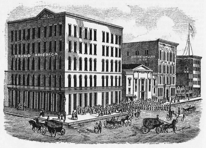
John M. Van Osdel, Rice’s Theater II, east side of Dearborn (in the middle of the block with the pediment) between Randolph (left) and Washington, 1850. (Andreas, History-Vol.2)
Rice hired Van Osdel to design a larger theater for an adjacent site on the east side of Dearborn, just south of Randolph. Chicago’s thespian endeavors, meanwhile, were moved to the temporary confines of “Tremont Hall,” a retrofitted dance hall in the then under-construction Tremont House. Rice’s new theater was more than twice the size of Chicago’s first theater house, with dimensions of 80′ by 100′ that could seat 1400, that included three tiers of boxes. To regain the confidence of his patrons, Rice had Van Osdel use as much brick as was feasible throughout the building. Van Osdel even went so far as to incorporate a galvanized iron cornice in place of the conventional wood cornice (this entailed nothing more than a galvanized sheet metal covering over the wood cornice that was believed at the time to be able to protect the wood from fire) as a statement of the building’s fireproof intention. In order to minimize the loss of business and interest of his audience, Rice had construction proceed at a record pace, so that the new building was completed by January, opening to its first audience on February 3, 1851.
National Amphitheater (far right), Monroe, between La Salle and Wells, 1855. Note that La Salle Street has not been extended south of Monroe. At the far left is the water reservoir on the site of the future Rookery. (Kogan and Wendt, Chicago: A Pictorial History)
Rice had enjoyed a monopoly on both popular and highbrow culture for over four years, until Levi J. North arrived in town with his circus on April 4, 1855. North quickly perceived that Chicago had outgrown Rice’s ability to serve the expanding population and saw the potential for a large permanent home for his performers that could also present other attractions year-round. He erected the National Amphitheater three blocks south of Rice’s theater, responding to the increasing price of land near the river and the corresponding spread of the residential area to the south. Located on Monroe, between Wells and Clark, the wooden structure measured 90′ by 206′ which allowed it to seat over 3,000 spectators. When the doors opened on August 4, 1855, patrons proceeded up eight-foot-wide stairways to the boxes in the gallery from which they had a view of the 42′ diameter performance ring, the entire hall being lit by 120 gas jets. So successful was North’s initial investment in Chicago that he soon remodeled the Amphitheater so that it could also present legitimate theater and opera, in direct competition with Rice’s theater. Meanwhile, the need for popular entertainment seemed to have been filled when Colonel Joseph H. Woods opened his “Museum” on Randolph Street on July 2, 1856. Although among its “eight living wonders of the world” was the largest woman in the world (who reportedly weighed in at just under 900 pounds), unquestionably the favorite exhibit of museum goers was the ‘Zeuglodon,’ a ninety-six-foot-long fossil of a suspected monster from the past.
Wood’s Museum, Randolph, between Clark and Dearborn, 1856. The Matteson House with its rooftop cupola is visible immediately to the right of the museum. (Heise and Edgerton, Chicago: Center for Enterprise: Jevne and Almini-ICHi-00952)
FURTHER READING:
Andreas, Alfred T. History of Chicago- vols. 1&2. Chicago, 1884-1886. Reprint, New York: Arno Press, 1975.
Cropsey, Eugene H., Crosby’s Opera House: Symbol of Chicago’s Cultural Awakening, Cranbury, NJ: Associated University Presses, 1999.
Mack, Edwin F. Old Monroe Street: Notes on the Monroe Street of Early Chicago Days. Chicago: Central Trust Company, 1914.
Pierce, Bessie Louis. A History of Chicago– I. New York: Knopf. 1940.
Tallmadge, Thomas Eddy. Architecture in Old Chicago. Chicago: University of Chicago Press, 1941.
Van Osdel’s loss of the commission for the Second Presbyterian Church may have been a blessing in disguise, for his practice was growing as Chicago’s economy regained its lost vigor. In January 1848, he was hired by Common Council to design a combined municipal building and market hall, modeled in part after Boston’s Faneuil Hall. When the city’s lease of the Saloon Building had expired in 1842 at the depth of the depression, the city administration had moved to less expensive quarters in Mrs. Nancy Chapman’s two-story building at the northeast corner of Randolph and La Salle. By 1848, the population of the city had increased to 20,023, an increase of 12,000 from its size only four years earlier. (This translated into the fact that there were more newcomers in Chicago in 1848 than those who had been residents since 1844.)
It no longer seemed appropriate for the municipal government of such a large populace to still have to lease space for its everyday functions because it lacked its own permanent headquarters. In addition, the city’s burgeoning population had also outgrown the meager Market House erected in 1840 at the corner of State and Lake. Unfortunately, the city coffers were not deep enough to cover the cost of a traditional City Hall, so Chicago’s frugal leaders had Van Osdel combine a new, larger market hall with the program for the city’s space needs in order to help pay for the project. City leaders also avoided the cost of procuring the land for the project by placing the building in the middle of State Street, that, coincidentally, had been recently widened by a third to 120’ from the river south to Randolph Street. Hence, Van Osdel responded with a two-story brick and stone building that had a 40′ front on Randolph from which sprouted a clocktower and ran 180′ north to Benton Place. The first floor contained thirty-two market stalls, while the municipal offices were located on the upper floor. The upper floor was divided into four rooms: a 40′ by 20′ office for the city clerk occupied the south end, while an identical space at the north end was reserved for a library. The 40′ by 140′ space in the middle was divided into two rooms (40′ by 68′ and 40′ by 72′) by folding doors that could be opened up for Common Council meetings, the first of which took place on November 13, 1848. During this period, the County also had decided that it needed to expand its courthouse on the northeast corner of the Public Square and so commissioned Van Osdel to design and build a new courthouse (no images appear to have survived) on the southeast corner of the Square, directly south of the original 1835 Courthouse.
John M. Van Osdel, Municipal Building and Market Hall, State at Randolph, 1848. (Mayer and Wade, Chicago: Growth of a Metropolis)
9.4. THE TREMONT HOUSE
Faneuil Hall was not the first architectural influence that Boston had provided for Chicago, for even earlier the Tremont House had been so named after the famous Boston hotel. Van Osdel became involved with its western namesake after the second Tremont House (that was erected in 1840 after the original had also been destroyed by fire) burned on July 21, 1849. Its owners, Ira and James Couch, hired Van Osdel to design a replacement that would be the city’s grandest hotel, at the same location on the southeast corner of Dearborn and Lake Streets but on a much larger parcel of land. Van Osdel, following the latest fashion in New York, produced a magnificent five and a half-story brick Italian Renaissance palace or palazzo that was so much larger than any other local hotel that it was often referred to “Couch’s folly,” for people could not understand the necessity for such a large hotel. It was not only the tallest brick building in town, but also the first building in Chicago to incorporate imported stone trim (that was gray in color) that Van Osdel had shipped from a quarry in Lockport, N.Y. Similar to his recent design for the First Presbyterian Church, he eliminated all traces of a roof, opting for a straightforward expression of the hotel’s walls, which were capped with a bracketed cornice.
John M. Van Osdel, Tremont House III, southwest corner of Lake and Dearborn, 1849. Many important speeches, including the Senatorial campaigns by Douglas and Lincoln, were delivered from its balcony. (Gilbert, Chicago and its Makers)
The design of the elevations foreshadowed the challenge to be faced in the near future in the composition of the elevation of a tall building, for instead of detailing each story of windows as a line of independent openings in the building’s wall, Van Osdel grouped the windows of the third and fourth floors together into an elongated unit with a recessed spandrel, thereby imparting a vertical accent to the facade that helped to balance the building’s long, horizontal elevation. Hence, the upper four stories progressed upward in a subtle tripartite (three-part) rhythm of 1-2-1. This he placed atop a ground floor of stores that appear from its radical degree of openness to have been a cast iron storefront. The main entrance on Dearborn was marked by a two-story high portico that consisted of a set of paired columns at each corner from which sprung Van Osdel’s favorite entrance motif, the triumphal arch. This was placed in the center of the Dearborn facade, that Van Osdel had arranged into a composition of a center with corner pavilions by projecting the wall containing the last three windows at both ends ever so slightly as corner pavilions, that again helped to reinforce the vertical counterpoint of the long elevation.
FURTHER READING:
Andreas, Alfred T. History of Chicago- vols. 1&2. Chicago, 1884-1886. Reprint, New York: Arno Press, 1975.
Ericsson, Henry L. Sixty Years a Builder: The Autobiography of Henry Ericsson. Chicago: A. Kroch, 1942.
Industrial Chicago-vol. 1: The Building Interests. Chicago: Goodspeed, 1891.
Pierce, Bessie Louis. A History of Chicago–I I. New York: Knopf. 1940.
Randall, Frank A. History of the Development of Building Construction in Chicago (2nd ed.). Urbana, University of Illinois Press, 1999.
Upon being installed as the Pastor of the First Presbyterian Congregation, Rev. Flavel Bascom had initiated a series of anti-slavery lectures between December 1841 and May 1842. Not all of Bascom’s flock shared his radical abolitionist viewpoint, however, and the controversial talks seemed to be the spark needed by dissenters within the congregation to undertake the process of divorce. On May 5, 1842, just such a group of disaffected Presbyterians had met to organize a rival organization, that formally organized the Second Presbyterian Church on June 1 with the purpose of serving those who did not share Bascom’s activist views on abolition. By September 1842, they had erected a 40′ by 60′ frame building on the south side of Randolph, just east of Clark Street, only a block north of the parent congregation. The breakaway congregation grew at such a rate that its size soon approached that of its mother church, and as the First Presbyterian congregation began construction of its replacement building in 1847, the Second Presbyterians mounted a campaign later that year to build a comparably sized building not only as an obvious sign of maturity but also to give newly arrived members of the faith a real choice in picking a congregation in their newly-adopted hometown.
James B. Renwick, Second Presbyterian Church, NE corner of Wabash and Washington, 1849. Front elevation, looking northeast up Wabash Street. (Jevni)
Van Osdel, by then the recognized resident master of the design and construction of church steeples, was logically approached and asked to provide a design for the new building to be located on a site that while, strictly speaking, could be considered within the Church Row along Washington Street, in fact actually broke the Protestant tradition of locating around the Public Square. The congregation had chosen a lakefront site on Wabash, not unlike what the Catholics had done with St. Mary’s Cathedral, that may not have been all that coincidental since the Catholics were only a block to the south.
The lot for the new building was the northeast corner of Washington and Wabash, adjacent to the southern end of Dearborn Park, affording the congregation an uninterrupted view of the lake. The location next to the park guaranteed that the new church would present a prominent image not only to those who traversed the park, but also to newcomers who approached the city from the lake.
Renwick, Second Presbyterian Church. East elevation, overlooking Dearborn Park. (Bluestone, Building Chicago)
As unorthodox as the choice of their site seemed to be, it soon became obvious that this highly opinionated congregation also wanted something different from the rest of Chicago’s churches in the design of their church building. Apparently, they rejected Van Osdel’s initial design (that most likely was another variation of his by then tried-and-true scheme of a Greek temple front with a central tower) and instead turned to an out-of-towner for the design. Evidently this congregation felt it needed to emphasize that it was different not only from the First Presbyterian Church, but also from the rest of Chicago’s Christian establishment as well. In order to successfully make such a statement, the congregation’s leaders must have felt the necessity for hiring the nation’s leading proponent of the newly emerging style of the Gothic Revival, James B. Renwick of New York City.
Renwick produced what was generally agreed to be “the most imposing and inviting church edifice in the city.” Respecting the context and the proportions of the lot, he placed the main entrance on Wabash, marking the corner of the site with a 164′ high tower (this was exactly one foot taller than that of the First Presbyterian Church). This was just one of a number of deviations from the traditional Chicago Greco-Roman Revival church as it resulted in the characteristic Neo-Gothic asymmetric composition, for at the opposite corner the facade was flanked by only a 64′ high steeple. The site must have proved to be an enigma for Renwick, for while the placement of the main entrance on Wabash was a sensible decision that responded to the center of town, to the existing Church Row three blocks to the west, and to the prevailing traffic patterns, the potentially even more important view of the building from the park and from the lake would, therefore, have traditionally been the rear of the church. Renwick responded by placing another entrance on the east facade, thereby imparting at least the appearance of a front, rather than the rear of the building from this vantage point.
Renwick, Second Presbyterian Church. East elevation, overlooking Dearborn Park. (Andreas-vol. 2)
Equally departing from Chicago tradition was the use of stone, rather than brick, for the church’s exterior. If for no other reason, stone’s heavy weight had limited its use as a construction material in the early days of Chicago because it could normally only be transported in the winter, because the roads were so muddy during the rest of the year that stone could be transported only by sleighs when the roads were frozen. By this time, however, stone had become more available in the Chicago area and, therefore, less expensive to use. Central to the increased availability of stone had been the digging of the I&M Canal, that had uncovered at two locations, Lemont and Athens, an indigenous limestone in 1846 suitable for building (hence, its local nickname: “Athenian marble”). The use of this stone had been facilitated by the steam-powered stone saw as well as by the quicker and cheaper transportation of the canal itself. These local quarries were, at first, not capable of producing the large quantity of dressed stone needed to clothe the exterior of a building, however, so the local stone was initially reserved solely for the foundations of the city’s larger structures.
In contrast to the spartan quality of the First Presbyterian Church, the leaders of the off-shoot congregation decided to spare no expense. A local limestone from a newly opened quarry in the area was chosen that serendipitously contained small deposits of bitumen. Once in place and exposed to the heat of the sun, the bitumen softened and slowly oozed down the walls of the building, imparting an instant patina to the church. This not only reinforced the “ancient and unique appearance” of Renwick’s Gothic Revival design, but also made “the Spotted Church” a must stop for visiting sightseers. On January 24, 1852, members walked into their new Second Presbyterian Church for the dedication of its trend-setting building. Adding salt to the wounds already suffered by the First Presbyterian congregation, however, was the fact that the new church’s final price tag of $40,000, a cost roughly 25% greater than that paid by the former for the erection of their new building, was already completely paid for by the upstart congregation. To manage the construction of the church, Renwick had sent one of his draftsman, Asher Carter, a self-taught carpenter, who decided to stay in Chicago and try his hand at designing. Chicago had gained its second practicing architect.
Renwick, Second Presbyterian Church. The “spots” are quite visible. (Tallmadge, Architecture in Old Chicago)
FURTHER READING:
Andreas, Alfred T. History of Chicago- vols. 1&2. Chicago, 1884-1886. Reprint, New York: Arno Press, 1975.
Bluestone, Daniel. Constructing Chicago. New Haven: Yale University Press, 1991.
Pierce, Bessie Louis. A History of Chicago– I. New York: Knopf. 1940.
With the national economy in full recovery by 1848, and Chicago’s network of rails beginning to spread in all four directions that would allow the trains to bring people to the city, its population had started to explode. When Ogden had placed his first wooden tie at Kinzie and Halsted in 1848, Chicago’s population was 20,023; in 1857, the city’s new railroads had assisted in the growth of its population to 93,000 (roughly four out of every five people on the city’s sidewalks had arrived since 1848). New housing for over 70,000 people had to be constructed in only nine years. The city would also be forced to accommodate this growth in all areas of its institutions and buildings.
9.1. THE FIRST PRESBYTERIAN CHURCH
While Chicago’s economy during the period 1845-47 began to regain its robust pre-Panic boom-town atmosphere, the city’s churches had all they could do in keeping the heads of their congregation from being turned once again by the temptations of Mammon. The Protestant congregations strove to fill the new buildings they had all built around the Public Square. All of the congregations, that is, except the Presbyterians, who had chosen to refrain from the building competition and instead, continued to use their enlarged original building that they had moved to the southwest corner of Washington and Clark in 1839. Their lack of interest in a new building may have been the result of other congregational priorities, for the First Presbyterian Church was known as the nucleus of Chicago’s growing abolitionist movement. These sentiments were undoubtedly brought to the surface by the congregation’s third pastor, Rev. Flavel Bascom, who had arrived in Chicago in December 1839. Raised in the Northeast and a graduate of Yale College, Bascom was steeped in a religious tradition of activist concern and involvement in public issues. As soon as he had arrived in town he attended (perhaps even organized) Chicago’s first anti-slavery meeting. Through Bascom’s efforts, the First Presbyterian Church housed a series of anti-slavery lectures that began in 1841.
Regardless of the notoriety gained through this selfless campaign, the congregation eventually had to take a long, critical look at its frumpy frock of a building that was now surrounded by the new elaborate edifices erected by its spiritual neighbors. Finally in 1847, two years after the Methodists across the street had finally replaced their original building, the Presbyterians commissioned Van Osdel to design a steeple taller than the one he had completed for the Methodists. The congregation was not, however, as financially well-endowed as their neighbors, which forced Van Osdel into a number of compromises. Judging by a later photograph of the building, the importance of an elaborate steeple was paramount to the Presbyterians. While Van Osdel embellished the steeple with detail, including scrolled brackets and paired Ionic columns, the 66′ by 113′ body of the building was a plain, brick box, with the exception of the then standard columns (doric) in antis at the recessed entry. Gone was the Greek Temple pediment roofline that all the surrounding churches sported, replaced by a humble, horizontal cornice, from which the 163′ tower rather abruptly shot into the sky. Van Osdel’s cost-cutting efforts notwithstanding, the extravagant steeple had contributed to the final cost of $28,000, which far exceeded the congregation’s modest resources and placed a heavy burden of debt upon the church. Following the dedication of the new building in September 1849, Rev. Bascom, having seen the project through to completion, was relieved of the position at his own request, that he had so faithfully performed for the last ten years. Had the extreme cost of building Chicago’s tallest tower led to his undoing? Or had it been the conflict that had resulted from his strident abolitionist zeal?
John M. Van Osdel. Left: First Presbyterian Church with 163’ steeple, southwest corner of Washington and Clark, 1847. A view from the Courthouse cupola taken by Hessler in 1858. (Kogan and Wendt, Chicago: A Pictorial History)
FURTHER READING:
Andreas, Alfred T. History of Chicago- vols. 1&2. Chicago, 1884-1886. Reprint, New York: Arno Press, 1975.
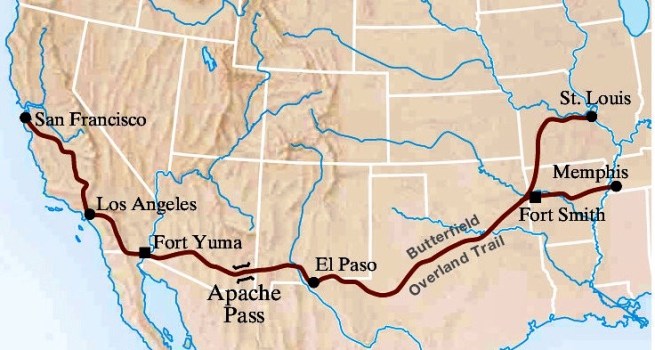
The ongoing battle between the railroads and the riverboats notwithstanding, the need for faster communications between the East Coast and California was such that Congress on March 3, 1857, authorized the Postmaster General to advertise for bids to establish regular mail delivery between San Francisco and St. Louis. As San Francisco was the largest community along the Pacific Coast as well as a naval base, this terminus was a given. St. Louis, as I have been noting all along, was in the middle of the country and therefore, acceptable, and convenient to both North and South. The contract was awarded to John Butterfield, who had proposed a southern route around the mountains, even though it was 600 miles longer, in deference to the practical limitations of horse-drawn coaches through snow-covered mountain passes. However, even this decision could not avoid antebellum politics and the Postmaster General, who was from Tennessee, saw to it that Memphis, in addition to St. Louis, was also made a terminus, the two routes joining at Fort Smith, AR.
The Route of the Butterfield Overland Express.
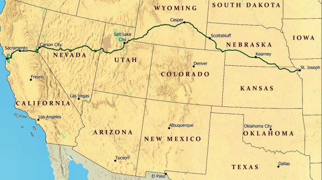
It took Butterfield over a year and a half to assemble the stations, coaches, horses, and drivers, but on September 15, 1858, the first of the regular bi-monthly Butterfield Overland Mail coaches set-off from St. Louis. No longer did mail between the two coasts have to sail to Panama (regular railroad service across Panama had begun in 1855) and back, but more to the point, as late as 1858, St. Louis in the center of the country, was still the preferred jumping-off point for the Pacific coast. But it was St. Louis’ last hurrah, for Chicago’s ever-expanding railroad web had finally crossed the Mississippi and a similar express mail service to Sacramento, CA, the Pony Express, was initiated on April 3, 1860. This presaged a change in the wind because its eastern terminus was not St. Louis, but St. Joseph, MO. While St. Joseph was only 75 miles north of St. Louis, it was connected via the Hannibal & St. Joseph and the Chicago. Burlington & Quincy Railroads to Chicago. For all but the cleaning up after, Chicago won the battle with St. Louis to become the center of the West. Boston’s perseverance in constructing T.H. Perkins’ “Railroad scheme,” a railroad to link Boston to the Pacific (and the “China Trade”) had succeeded, some thirty-two years after the first wooden tie for the Boston & Worcester had been laid. Perkins, however, didn’t quite live to see his vision competed; he had died in 1854.
Above: The Route of the Pony Express; Below: Route of the H&StJ from St. Joseph to Quincy, and then on to Chicago.
8.13. THE ROUTE TO CHICAGO FROM THE EAST IS COMPLETED
The IC station in Chicago finally opened on June 12, 1856, poignantly only three weeks after the sack of Lawrence, KS. The IC was by then longest railroad in the world, and when combined with the other lines that connected to Chicago, made the city the hub of the largest network of railroad tracks in the U.S., if not in the world.
“In 1857 Chicago had nearly four thousand miles of railroad tributary to herself, and the joint earnings of the companies amounted to over eighteen and a half millions of dollars!… [at the time of] the Rockford Convention of 1847, Chicago had not a mile of road… by 1855 [it had] almost 3,000, while, within a period of two years more, another thousand was added to the three. The world had never before saw such a stride made towards commercial supremacy.”
This network linked the NorthWest not only to the East Coast, but also to the South and would allow Chicago to pull abreast of its two river city competitors to the south, Cincinnati and St. Louis, in terms of economic and political importance by the start of the Civil War. In 1848, when Ogden had placed his first wooden tie at Kinzie and Halsted, Chicago’s population was 20,023; in 1857, the city’s new railroads had assisted in the growth of its population to 93,000 (roughly four out of every five people on the city’s sidewalks had arrived since 1848). In 1857, there were four roads linking Chicago to the East Coast:
Michigan Southern and Northern Indiana
Michigan Central
Grand Trunk (through Canada, north shore of Lake Erie, bridge over Niagara Falls)
(the Pittsburgh, Ft. Wayne, and Chicago would be completed in 1858, making a connection with the Pennsylvania RR to Philadelphia -see Chap. 9)
There were six trunk lines leaving Chicago for the north, the west, and the south. Starting from the north and rotating counterclockwise:
Chicago & Milwaukee (see Chap. 9)
Illinois & Wisconsin
Galena & Chicago Union
Chicago, Burlington, and Quincy (using the tracks of the G&CU to/from Turner Junction)
Joliet & Chicago (see Chap. 9; it was reorganized in 1861 as the Chicago & Alton)
Chicago & Rock Island
Illinois Central
There were now five terminals in Chicago (that served these railroads). Starting from the north and rotating clockwise:
the Illinois & Wisconsin Station (I&W, C&M)
the Galena & Chicago Union Station (G&CU, CB&Q)
the Illinois Central Station (IC, MC)
the Chicago & Western Indiana-Dearborn Station (GT, Erie)
the Michigan Southern and Rock Island-La Salle Station (MS, C&RI, J&C)
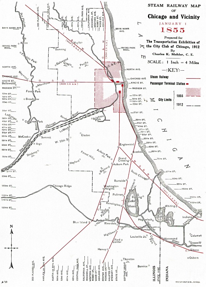
1855 Chicago Railroad Map. It shows four of the five stations ringing the business district: clockwise from the northwest- Illinois & Wisconsin, G&CU, IC (and MC), and MS/RI. Curiously missing is the Dearborn Station of the C&WI (GT and Erie).
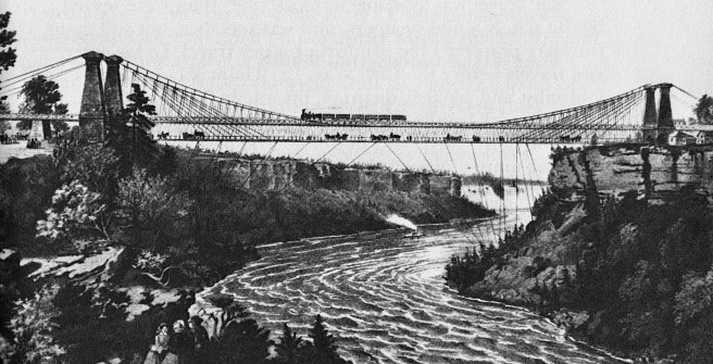
These were located strategically around the periphery of the business district, yet Common Council had not allowed one iron rail of the world’s largest railroad network to be laid within the 64-block grid of this district. By this date, the last link in the through route from Boston, John Roebling’s suspension bridge across the Niagara valley had been completed in March 1855, thereby completing the Great Western Railroad in Canada along the northern shore of Lake Erie between Buffalo and Detroit. It was now possible to board a Boston & Worcester train at State Street in Boston, and travel by railroad (except for a ferry across the Detroit River) to within a three block walk of State Street in Chicago:
“As we approached Chicago, the prairie subsided into swampy land, and thick belts of trees fringed the horizon; on our right glimpses of sea could be caught through openings in the wood – the inland sea on which stands the queen of the lakes. Michigan looks broad and blue as the Mediterranean. Large farmhouses stud the country, and houses which must be the retreat of merchants and citizens of means; and when the train, leaving the land altogether, dashes out on a pier and causeway built along the borders of the lake, we see lines of noble houses, a fine boulevard, a forest of masts, huge isolated piles of masonry, the famed grain elevators by which so many have been hoisted to fortune, churches and public edifices, and the apparatus of a great city. And just at nine o’clock the train gives its last steam shout and comes to a standstill in the spacious station of the Central Illinois Company, and in half-an-hour I am in comfortable quarters at the Richmond House.”
John Roebling, The Suspension Railroad Bridge over Niagara River, near Niagara Falls, NY, completed March 17, 1855. A double deck bridge with a span of 822 feet. Note the diagonal stays below the lower deck to the ground, stabilizing the bridge deck. The upper deck carried New York Central trains over the river to make a connection with the Great Western trains that would take passengers to Detroit and the Michigan central. (Stover, Iron Road to the West)
FURTHER READING:
Andreas, Alfred T. History of Chicago- vols. 1&2. Chicago, 1884-1886. Reprint, New York: Arno Press, 1975.
Borneman, Walter R., Iron Horses: America’s Race to Bring the Railroad West, New York: Back Bay, 2010.
The increasing resistance to slavery ignited by Douglas’ Kansas-Nebraska Bill finally brought the opponents of slavery who were either former Whigs or Democrats together and coalesced into the Republican Party, formally established at a convention held in Pittsburgh on February 22, 1856. This group tasked each state to organize a State Republican Party, to be led by a Central Committee, in order to be able to call for a national Presidential Convention. Illinois’ convention was set to be held in Bloomington on May 29, 1856, with Ogden being named the delegate from the state’s Second District and Norman Judd named to the Committee on Resolutions. But three weeks before the convention, the Effie Afton, a steamboat owned by St. Louis businessman John Hurd, suspiciously “crashed” into Farnam’s bridge over the Mississippi within two weeks of its completion on May 6, 1856, setting the boat as well as a portion of the bridge on fire. Hurd filed a suit against the Chicago railroad and its bridge for damages (at that time Ogden was the Vice-President of the M&M that was the continuation of the C&RI on the other end of the bridge). St. Louis and its steamboat interests were simply not just going to lie down and surrender to Chicago’s railroads. The Mississippi River was St. Louis’ last line of defense and Farnum’s bridge at Rock Island was the first attempt to breech it. Having failed first to prevent its construction via the Federal government’s rather anemic efforts by Sec. of War Davis, St. Louis’ interests had no alternative but to destroy the bridge as soon as possible, and then enjoin in a litigation battle to prevent its replacement on the grounds that a bridge over the river interfered with the free navigation rights of the steamboat owners.
Hurd filed a suit against the Chicago railroad and its bridge for damages, while Farnum set out to repair the damaged bridge as quickly as possible. Judd, the bridge company’s president, however, had more immediate matters to attend to with the organizing of the “new” state Republican Party at its convention in Bloomington. Its closing address was delivered by forty-seven-year-old Springfield attorney Abraham Lincoln. Following his disappointing loss of not being named Commissioner of the Federal Land Office by Pres. Taylor in 1849, Lincoln had retired from politics and returned to his private law practice, focusing on transportation cases, eventually moving into the new arena of railroad law. By 1856 Lincoln had already made a name for himself in cases that dated back to 1851 that involved the railroad industry and its corresponding issues, his most recent client being the Illinois Central Railroad. Lincoln historians credit Douglas’ Kansas-Nebraska Act as the spark that had reinvigorated Lincoln’s political ambitions, in that he entered the 1854 campaign for Illinois’ U. S. Senate seat, then held by Douglas stalwart James Shields, with a series of speeches in which he laid out his opposition to Douglas’ support of “Popular Sovereignty.” Although Whig Lincoln had led at the start of the voting in the Illinois Senate, his support began to dwindle as the Democrats were forced to drop Shields and began to vote for Governor Joel Matteson. Lincoln eventually threw his support behind “Anti-Nebraskan” Democrat Lyman Trumbull, who ended up serving in the Senate for the next eighteen years. Nonetheless, Lincoln had quickly emerged as the state’s leading “Anti-Nebraskan” at the time of the Effie Afton’s crash into the Rock Island’s bridge.
Lincoln’s closing speech at the convention is known as Lincoln’s “Lost Speech” as there are no surviving accounts or transcripts. While all of the convention’s attendees attest to the power of the speech, some historians blame its power for its loss as reporters forgot to take notes while under its spell, while other historians posit that Lincoln’s supporters asked reporters to “lose” their notes as its strong denunciation of slavery was ahead of its time and might jeopardize Lincoln’s planned run against Douglas’ for his Senate seat in 1858. Although Ogden had been forced by other matters to decline to attend the state convention, Judd was so effective in organizing the entire proceedings that he was appointed to the powerful position of Chairman of the State Central Committee, from which he would influence future events that would steer Lincoln into the Presidency. Judd was an obvious choice as the Chairman of the Illinois delegation to the Party’s National Convention in Philadelphia on June 17-9, 1856, that nominated the great explorer John C. Frémont as its presidential candidate. (The previous year his father-in-law, Sen. Benton, had lost his last election as Missouri’s divided politics would no longer support his moderate and Unionist views.) With a party plank that called for a transcontinental railroad along St. Louis’ “compromise” central route, the convention slogan quickly became, “Freedom, Frémont, and the Railroad.” At the convention Lincoln was narrowly defeated as the party’s candidate for Vice-President. At the same convention, Judd was named to the Republican National Committee that would be responsible for choosing the site of the party’s 1860 national convention.
Meanwhile, as the two sides of the Hurd v. Rock Island Bridge Company case neared their day in court, slated for Sept. 1857, Farnum and Judd retained the rising star of the new Republican Party, Lincoln with only four weeks before the trial was to begin, to represent the companies in court. Lincoln set out to defend the railroad bridge against Hurd’s suit, in which he was successful in getting a favorable verdict that was appealed and not finally settled until 1872 in favor of the railroad. The Effie Afton, however,was by no means the only attempt by St. Louis steamboat interests to destroy the Rock Island bridge. Numerous boats were made to crash into the bridge, allowing their owners to sue the bridge company in hopes of having the courts force the demolition of the bridge. The low point in this tragic battle between Chicago and St. Louis came in June 1859, when a watchman had found a bomb constructed on the bridge’s roadbed.
This was the situation on the ground when Douglas returned from his European travels. The treaty that resulted in the Gadsden Purchase, signed on December 30, 1853, had upped the pressure on the Northerners to find a solution to the Nebraska problem. Douglas believed he had to act before the date that Davis was to receive the results of the then-underway surveys, that initially was scheduled for February 6, 1854, or he would lose what little leverage he still had with the Southerners. Davis, at the same time, also understood that time was now acting against his plans, in that not only were the surveys not completed as scheduled, requiring an extension, but Farnum was quickly closing in on the Mississippi that he finally reached on February 22. Davis needed to slow down Farnum’s construction and finally realized that he had just the opportunity to do so by stopping Farnum’s bridge construction on the Federal jurisdiction of Rock Island. On April 19, he ordered Farnum to cease construction of the bridge, but got no response from the bridge company’s president, attorney Norman Judd. Davis then dispatched the U.S. Marshall for the District of Illinois to enforce his order who arrived in Rock Island on July 17, 1854. “For some unknown reason,” the Marshall, however, did not complete his assigned duties to confront Pres. Judd. Davis, however, did not give up without making a last-ditch attempt to stop Farnum’s progress; in July 1855 he asked for injunction to stop the construction of the Rock Island bridge. Fortunately, the case was heard in the U.S. Circuit Court for Northern Illinois, with Judd representing his company. Judge John MacLean ruled that as the Federal government had abandoned the island, it could not now claim that it still had jurisdiction over it. It was now public land, and thus, “a State has the power to construct a public road through public lands.” Ogden’s Pacific railroad continued to run right on schedule.
As the Rock Island battle was being played out, Douglas had been attempting to bring the Nebraska issue to a final resolution. Even though the Missouri Compromise of 1820 had required that all land in the Louisiana Purchase west of Missouri and north of Missouri’s southern border would be forever free of slavery, the Mexican-American War had revealed that much of the land south of this line was relatively uninhabitable, with the consequence that its population might not be sufficient to apply for statehood (indeed, Arizona did not achieve statehood until 1912), that could possibly put the Southern states at a long-term political disadvantage. Southern senators, therefore, were opposed to the Nebraska territory (which at this time included all of what would become the State of Kansas) being organized as a formal entity unless the concept of the Compromise of 1850, that is, the avoidance of the Missouri Compromise’s prohibition of slavery above the 36° 30’ line, was also applied to this territory as well.
Such insistence had prevented any resolution of the Nebraska issue during 1853 as Southerners held the majority in the Senate. Pressure from both sides, however, was mounting to form a territorial government as settlers were crossing into the area along its border. A meeting of such settlers was held in St. Joseph, MO, in early January 1854 to press the matter in Congress. Douglas wrote a letter to the meeting expressing his support of the issue and at the same time, Douglas released his draft of a Nebraska Bill from his Committee on Territories on Janaury 4, 1854, in which he had applied Popular Sovereignty, thereby once again choosing to ignore the Missouri Compromise of 1820. As opposed to his success in forging a compromise in 1850, however, the political winds of the country in 1854 had begun to harden on both sides of the slavery issue to the point where no such overarching solution as was the Compromise of 1850, would be agreeable to the majority of the country. Following three weeks of political debate and horse-trading, Douglas completely surprised the Senate on January 23 by presenting a completely new bill, one that had split the originally planned territory into two, carving out the Territory of Kansas in the south, while the remainder was to become the Territory of Nebraska in the north, appropriately changing the name of the legislation to the Kansas-Nebraska Bill. While his Northern critics charged that he had given in to Southern interests, Johannsen argued that the changes were made by Douglas in response to more pragmatic and political concerns, more immediate to the securing of votes for its passage, for Farnum was scheduled to reach the Mississippi within a month, with the bridge then already under construction, and was about to begin laying tracks through Iowa.
Maps of the U.S. in 1854 due to the Kansas-Nebraska Act.
The debate in both houses was long and intense, but eventually Douglas rammed through the Kansas-Nebraska Act over the objections of Northern abolitionists, including Douglas’ long-time Democrat ally John Wentworth, with President Pierce signing it into law on May 30, 1854. Southerners got a territory north of the Compromise of 1820 36° 30’ line where slavery could be approved in a vote by its residents, and for the cost of what was to become “Bleeding Kansas,” Douglas got a territorial government in Nebraska that could eventually charter the next link in Chicago’s railroad to the Pacific. The price for Douglas’ blind ambition for Chicago’s railroad to the west had been the de facto removal of the thirty-four-year-old ban on slavery in the Louisiana Territory north of the 36° 30’ parallel.
To Douglas’ credit, he believed that “geography and climate” would prove to be a natural limiting factor in the northern extension of slavery (short staple cotton required a minimum of 200 frost-free days) and had no doubt that he had snookered the Southerners (that history has proven to be true). Unfortunately for his immediate political ambitions, the more ideologically opposed to slavery “Free-Soiler” Northern abolitionists took Douglas’ tacit approval of the extension of slavery and foisted him on his own petard. His abandonment of the Missouri Compromise reignited the abolitionist sentiment of the Free-Soilers of 1848 and was directly responsible for the formation of the Republican Party later that year. In anticipation of the passage of the Kansas-Nebraska Act, a group opposed to the extension of slavery had actually met on March 20, 1854, in Ripon, WI, where the name “Republican Party” was first mentioned. Following the final passage of the Kansas-Nebraska Act, the name was formalized at the party’s first convention in Jackson, MI, on July 6. Beyond Douglas’ long-term presidential ambitions, however, as many of his former Chicago supporters, including Ogden, Wentworth, and Judd, abandoned the Democratic party and joined the new “Anti-Nebraska” Republican Party, the more immediate cost of the extension of Chicago’s transcontinental railroad toward the Nebraska territory would be the bloodshed in Kansas up to the start of the Civil War, that included at least 55 deaths, and the pillaging of the town of Lawrence on May 21, 1856.
Map of western railroads as of 1860. Leaving Chicago, the northernest line in Illinois is the Rock Island; the second is the Burlington. (Online)
Meanwhile, all Douglas had to do to continue assisting the construction of the northern route once the Kansas-Nebraska Act had been signed by Pres. Pierce, was to indefinitely stretch out the decision process over the transcontinental railroad in Congress as increased Sectional bickering prevented any financial support of the start of construction of any of the five routes. This played directly into the hands of Chicago’s railroad builders, for there were three private companies in 1856, the Chicago & Rock Island, the Galena & Chicago Union, and the Chicago, Burlington, & Quincy, that were furiously continuing what Ogden had started back in the summer of 1848, that is, laying their tracks west to the Pacific. Left to their own devices, these companies following the signing of the Kansas/Nebraska Act would eventually be able to now build the transcontinental railroad into Nebraska without any further interference from Southern politicians. Farnum’s Rock Island had been the first to reach the Mississippi on Feb. 2, 1854, with its bridge being completed on April 21, 1856.
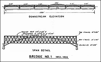
Henry Farnam, Rock Island Railroad Bridge over the Mississippi River at Rock Island, 1853-6. The bridge comprised of wood and iron trusses that were 250’ in length, except the swing section that was 285’ in length. This swung around a central pier that left a 120’ clear channel on either side. (Pfeiffer, Bridging the Mississippi)
Meanwhile during the debate over the Nebraska Territory, Sec. Davis had finally received the reports from the survey teams studying the four potential routes that Congress had requested in 1853. Unfortunately, each one had its own negatives with the result that none had risen to the top of the list based solely on its scientific or financial merits, tossing the decision back into the political arena of Congress. Nonetheless, Davis published a three-volume summary of the surveys in the summer of 1855 that helped to frame the future debate over the issue. In August 1856, the House Select Committee on the Pacific Railroad and Telegraph distributed a report that stated the obvious:
“The necessity that now exists for constructing lines of railroad and telegraphic communication between the Atlantic and Pacific coasts of this continent is no longer a question for argument; it is conceded by every one. In order to maintain our present position on the Pacific, we must have some more speedy and direct means of intercourse than is at present afforded by the route through the possessions of a foreign power.”
While there was agreement about the necessity for such a railroad, it was the actual decision over which route it should take that continued to be unresolved by the stalemate in Congress, that would continue to play to Chicago’s advantage. Its railroads continued to lay tracks westward…
FURTHER READING:
Andreas, Alfred T. History of Chicago- vols. 1&2. Chicago, 1884-1886. Reprint, New York: Arno Press, 1975.
Borneman, Walter R., Iron Horses: America’s Race to Bring the Railroad West, New York: Back Bay, 2010.
Catton, Bruce, The Civil War, Boston: Houghton Mifflin, 1960.
Galloway, John Debo. The First Transcontinental Railroad. New York: Simmons-Broadway, 1950.
Karamanski, Theodore J. Rally ‘Round the Flag: Chicago and the Civil War, Chicago: Nelson-Hall, 1993.
Johannsen, Robert W. Stephen A. Douglas, New York: Oxford, 1973.
Mueller, Ken S. Senator Benton and the People. Dekalb: Northern Illinois University, 2014.
Pfeiffer, David A., “Bridging the Mississippi: The Railroads and Steamboats Clash at the Rock Island Bridge,” Prologue Magazine, Summer 2004.
“Report of the House Select Committee on the Pacific Railroad and Telegraph,” U.S. House of Representatives, 36th Congress, 1st Session, No. 358, August 16, 1856.
While Douglas was working out the series of bills that comprised the Compromise of 1850 as well as the IC deal in Congress during the summer of 1850, he also had to keep on top of the transcontinental railroad issue. There was one roadblock to be overcome if Chicago’s planned transcontinental railroad was to continue construction once it reached the Missouri River at Council Bluffs that the Illinois Legislature had little say in, but the approval of Southern politicians in Congress would be critical for this hurdle to be passed: as of 1853, there still remained the vast unorganized territory of “Nebraska” west of the Missouri River that was still in the titular possession of the Native tribes, that needed to be breeched, legally and physically, by any transcontinental line in the North.
Map of the U.S. in 1853 prior to the Kansas-Nebraska Act
Whether Douglas realized it or not during the heady days of his successes in September 1850 that were capped by the approval of the IC bill, he had actually been outflanked by the Southerners with the passage of the first of the Compromise bills on Sept. 9, that formed the Territory of New Mexico. This territory now physically linked Texas to California with a contiguous land route that was solely under the jurisdiction of the U.S. that removed the final legal and physical impediment to the approval of a southern route for the transcontinental railroad, for the New Mexico territorial government could finally grant a legal charter to a railroad company to build through its territory on its way to the Pacific. At the same time, Southern Democratic Senators, who held the majority in the Senate, had continued to prevent the farther extension of a northern route by opposing the formation of the Nebraska territory as one that was free from slavery, even though the Missouri Compromise of 1820 had seemingly guaranteed this provision.
During the two years that followed the passage of the 1850 Compromise, Douglas and his supporters, therefore, saw the transcontinental railroad’s momentum swing in the favor of the South, while Sen. Benton’s central route through the border states along the 39° parallel (the Cincinnati/St. Louis route) lay in the background as a compromise that both sides might eventually accept. Much of the southern route had already been surveyed by the U.S. Corps of Topographical Engineers following the end of the Mexican-American War while they were engaged in determining the exact location of the new border. While a feasible route in the newly acquired Mexican territory was eventually determined, an even geographically better route was found in the southern watershed of the Gila River along the 32° parallel that was still in Mexico, providing the motivation for the Southerners’ push to pass Federal funding to construct this route.
In January 1853, Texas Sen. Thomas Jefferson Rusk, intending to hold the nation’s two Sections together introduced a bill calling for the construction of two railroads, a northern one and a southern one. Rusk’s bill would have given the President the authority to choose the roues and the contractors. The South, however, was so divided on the issue that the bill got nowhere. Hoping to avoid any further Sectional bickering on the issue by “substitut[ing] the impartial judgment of science for the passions of the politicos and promoters,” California Senator William Gwin, a supporter of the southern route, and Sen. Salmon P. Chase of Ohio, a northern supporter, submitted a rather innocuous amendment to an Army Appropriation Bill, that Pres. Fillmore signed as one of his last formal acts in office on March 3, 1853, that directed the Secretary of War “to Ascertain the Most Practical and Economical Route for a Railroad From the Mississippi River to the Pacific Ocean.” To supporters of the Northern route, the amendment was a godsend in that it slowed the momentum behind the Southern route, while giving the Chicago roads more time to lay tracks to the west.
Democrat Franklin Pierce was inaugurated the next day as President. While being from New Hampshire he was no friend of the Abolitionists, and in order to give his cabinet some Sectional balance as an attempt to maintain national unity, had named Jefferson Davis to be Secretary of War, therefore, it fell to Davis to enact the surveys. Davis was from Mississippi and naturally favored the southernmost route along the 32° parallel from New Orleans through Texas, as it was the shortest in length as well as it would not have to contend with winter snows. To coordinate the surveys, he appointed a close personal friend, Maj. William H. Emory, who also was an advocate for the 32° parallel because he had actually led a survey of it after the end of the war. Davis initially authorized four surveys:
1. starting at Fort Snelling (today’s St. Paul), a route that followed the 48° parallel to Puget Sound,
2. starting at St. Louis, a route between the 40° and 38° parallels to San Francisco,
3. starting at Ft. Smith, AR, on the Arkansas River, a route that followed the 35° parallel to Los Angeles,
4. explorations in southern California between the 35° and 32° parallels to search for passes through the Sierra Madre Mountains.
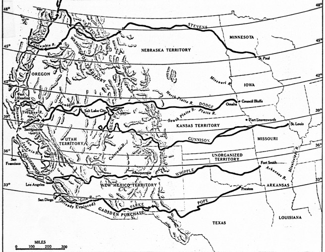
Surveyed Routes for the Transcontinental Railroad. In March 1853, Congress appropriated $150,000 to survey four possible routes. Those are shown with the names of the surveyor in charge. The actual route used with the Act of 1862, started from Council Bluffs/Omaha and was surveyed by Grenville Dodge, was not even considered in the 1853 survey, but is included on this map. (Time-Life, Old West Railroads)
The surveying teams were given one year to complete their tasks by the first Monday in February 1854. Conspicuous by its absence was Davis’ favored route along the 32° parallel. Undoubtedly, its survey was postponed because some of the route traversed land still owned by Mexico. Curiously, Davis had completely ignored the route from Omaha along the 42° parallel that Chicago’s roads were building at that precise moment.
Meanwhile, Sen. Douglas’s beloved wife, Martha, had died after childbirth in January 1853 and believing that the time-consuming surveys had bought himself another year to resolve the Nebraska issue (while at the same time buying more time to allow Chicago’s railroads to continue to lay tracks to the Mississippi), Douglas took a well-deserved break with a far-flung tour of Europe during the summer of 1853 (whose timing coincided with that of Ogden’s trip). During this time, Farnum was closing in on the Mississippi with the Rock Island’s tracks and had already chartered the next link in Chicago’s transcontinental railroad, the Mississippi & Missouri, to build through Iowa west of the Mississippi from Davenport, IA, on the shore opposite from Rock Island to Council Bluffs. While Farnum also served as the President of the new M&M, Ogden, who was no longer President of the G&CU, had agreed to serve as its Vice-President and Norman Judd was made a Director in addition to being its corporate attorney. On July 16, 1853, some six months before the C&RI’s tracks were completed to the river, Farnum had commenced construction at Rock Island of the first bridge over the Mississippi in order to connect the C&RI with the planned route through Iowa.
Henry Farnam, Rock Island Railroad Bridge over the Mississippi River at Rock Island, 1853-6. The bridge comprised of wood and iron trusses that were 250’ in length, except the swing section that was 285’ in length. This swung around a central pier that left a 120’ clear channel on either side. (Pfeiffer, Bridging the Mississippi)
Rock Island had first been chosen as the best location to bridge the Mississippi by William Redfield in 1830 because its location in the river would shorten the span of the bridge needed to cross the river. Because the boundary between Illinois and Iowa was located at the center of the main channel between the island and the Iowa shore, neither the Rock Island’s charter nor that of the M&M had granted either company the authority to build a bridge that extended into the other’s state, therefore, a new company, the Rock Island Railroad Bridge Company was chartered by the Illinois Legislature in 1853 to “build, maintain, and use” the bridge. Norman Judd was strategically (as will soon be revealed) named the President of the company, while Farnum took no chances with the design of the bridge as he designed it himself. It comprised of three parts: a bridge over the slough between the Illinois shore and the island, a short line of tracks on the island itself, and the bridge over the main branch of the river between the island and the Iowa shore that would be completed on April 21, 1856.
By that date, however, the national political situation had so deteriorated from what it was when the bridge’s construction began in July 1853, that the bridge’s construction over the Mississippi seemed like an apt metaphor for the internal conflict that had erupted throughout the country, including Chicago. The Federal government still owned the island itself, even though Fort Armstrong had been abandoned since 1845, so Farnum was legally obliged to apply for a grant of land along his proposed right-of-way. Farnum’s request was received by Secretary of War Davis, whoattempted to stall the northern route by “studying the merits” of Farnum’s proposal without reaching any conclusion during which time the four transcontinental surveys were in the field. In good Chicago “I will” fashion, Farnum eventually decided unilaterally to begin construction with or without Davis’ approval. Meanwhile, Davis and Pres. Pierce had initiated their own unilateral efforts to move forward, ignoring Northern Congressional resistance, on the 32° parallel route. Pierce appointed James Gadsden, who had just recently stepped down as the president of the South Carolina Railroad, where he had been a leading advocate for John C. Calhoun’s (who had died in 1850) Southern transcontinental railroad, as the new U.S. Minister to Mexico and tasked him with the duty to negotiate the purchase of the land south of the Gila River from Mexico, needed to construct the better of the southern routes. Anticipating a successful conclusion to these negotiations, Davis in October 1853 had then sent two surveying parties to survey this route to make up for lost time so that this route could also be included in his final report. The race was on between Farnum, who was building the bridge over the Mississippi for the Chicago route that Davis had purposefully ignored in the transcontinental railroad surveys, while Davis himself had his survey teams laying out the Southern route along the Gila River.
FURTHER READING:
Andreas, Alfred T. History of Chicago- vols. 1&2. Chicago, 1884-1886. Reprint, New York: Arno Press, 1975.
Borneman, Walter R., Iron Horses: America’s Race to Bring the Railroad West, New York: Back Bay, 2010.
Johannsen, Robert W. Stephen A. Douglas, New York: Oxford, 1973.
Milton, George Fort. The Eve of Conflict: Stephen A. Douglas and the Needless War. New York: Octagon, 1969.
Pfeiffer, David A., “Bridging the Mississippi: The Railroads and Steamboats Clash at the Rock Island Bridge,” Prologue Magazine, Summer 2004.