
While Douglas was working out the series of bills that comprised the Compromise of 1850 as well as the IC deal in Congress during the summer of 1850, he also had to keep on top of the transcontinental railroad issue. There was one roadblock to be overcome if Chicago’s planned transcontinental railroad was to continue construction once it reached the Missouri River at Council Bluffs that the Illinois Legislature had little say in, but the approval of Southern politicians in Congress would be critical for this hurdle to be passed: as of 1853, there still remained the vast unorganized territory of “Nebraska” west of the Missouri River that was still in the titular possession of the Native tribes, that needed to be breeched, legally and physically, by any transcontinental line in the North.

Whether Douglas realized it or not during the heady days of his successes in September 1850 that were capped by the approval of the IC bill, he had actually been outflanked by the Southerners with the passage of the first of the Compromise bills on Sept. 9, that formed the Territory of New Mexico. This territory now physically linked Texas to California with a contiguous land route that was solely under the jurisdiction of the U.S. that removed the final legal and physical impediment to the approval of a southern route for the transcontinental railroad, for the New Mexico territorial government could finally grant a legal charter to a railroad company to build through its territory on its way to the Pacific. At the same time, Southern Democratic Senators, who held the majority in the Senate, had continued to prevent the farther extension of a northern route by opposing the formation of the Nebraska territory as one that was free from slavery, even though the Missouri Compromise of 1820 had seemingly guaranteed this provision.
During the two years that followed the passage of the 1850 Compromise, Douglas and his supporters, therefore, saw the transcontinental railroad’s momentum swing in the favor of the South, while Sen. Benton’s central route through the border states along the 39° parallel (the Cincinnati/St. Louis route) lay in the background as a compromise that both sides might eventually accept. Much of the southern route had already been surveyed by the U.S. Corps of Topographical Engineers following the end of the Mexican-American War while they were engaged in determining the exact location of the new border. While a feasible route in the newly acquired Mexican territory was eventually determined, an even geographically better route was found in the southern watershed of the Gila River along the 32° parallel that was still in Mexico, providing the motivation for the Southerners’ push to pass Federal funding to construct this route.
In January 1853, Texas Sen. Thomas Jefferson Rusk, intending to hold the nation’s two Sections together introduced a bill calling for the construction of two railroads, a northern one and a southern one. Rusk’s bill would have given the President the authority to choose the roues and the contractors. The South, however, was so divided on the issue that the bill got nowhere. Hoping to avoid any further Sectional bickering on the issue by “substitut[ing] the impartial judgment of science for the passions of the politicos and promoters,” California Senator William Gwin, a supporter of the southern route, and Sen. Salmon P. Chase of Ohio, a northern supporter, submitted a rather innocuous amendment to an Army Appropriation Bill, that Pres. Fillmore signed as one of his last formal acts in office on March 3, 1853, that directed the Secretary of War “to Ascertain the Most Practical and Economical Route for a Railroad From the Mississippi River to the Pacific Ocean.” To supporters of the Northern route, the amendment was a godsend in that it slowed the momentum behind the Southern route, while giving the Chicago roads more time to lay tracks to the west.
Democrat Franklin Pierce was inaugurated the next day as President. While being from New Hampshire he was no friend of the Abolitionists, and in order to give his cabinet some Sectional balance as an attempt to maintain national unity, had named Jefferson Davis to be Secretary of War, therefore, it fell to Davis to enact the surveys. Davis was from Mississippi and naturally favored the southernmost route along the 32° parallel from New Orleans through Texas, as it was the shortest in length as well as it would not have to contend with winter snows. To coordinate the surveys, he appointed a close personal friend, Maj. William H. Emory, who also was an advocate for the 32° parallel because he had actually led a survey of it after the end of the war. Davis initially authorized four surveys:
1. starting at Fort Snelling (today’s St. Paul), a route that followed the 48° parallel to Puget Sound,
2. starting at St. Louis, a route between the 40° and 38° parallels to San Francisco,
3. starting at Ft. Smith, AR, on the Arkansas River, a route that followed the 35° parallel to Los Angeles,
4. explorations in southern California between the 35° and 32° parallels to search for passes through the Sierra Madre Mountains.
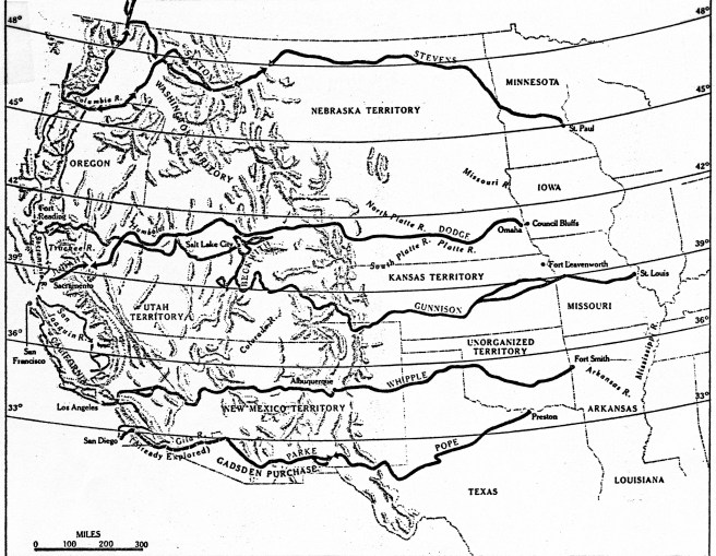
The surveying teams were given one year to complete their tasks by the first Monday in February 1854. Conspicuous by its absence was Davis’ favored route along the 32° parallel. Undoubtedly, its survey was postponed because some of the route traversed land still owned by Mexico. Curiously, Davis had completely ignored the route from Omaha along the 42° parallel that Chicago’s roads were building at that precise moment.
Meanwhile, Sen. Douglas’s beloved wife, Martha, had died after childbirth in January 1853 and believing that the time-consuming surveys had bought himself another year to resolve the Nebraska issue (while at the same time buying more time to allow Chicago’s railroads to continue to lay tracks to the Mississippi), Douglas took a well-deserved break with a far-flung tour of Europe during the summer of 1853 (whose timing coincided with that of Ogden’s trip). During this time, Farnum was closing in on the Mississippi with the Rock Island’s tracks and had already chartered the next link in Chicago’s transcontinental railroad, the Mississippi & Missouri, to build through Iowa west of the Mississippi from Davenport, IA, on the shore opposite from Rock Island to Council Bluffs. While Farnum also served as the President of the new M&M, Ogden, who was no longer President of the G&CU, had agreed to serve as its Vice-President and Norman Judd was made a Director in addition to being its corporate attorney. On July 16, 1853, some six months before the C&RI’s tracks were completed to the river, Farnum had commenced construction at Rock Island of the first bridge over the Mississippi in order to connect the C&RI with the planned route through Iowa.
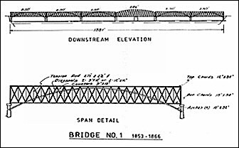
Rock Island had first been chosen as the best location to bridge the Mississippi by William Redfield in 1830 because its location in the river would shorten the span of the bridge needed to cross the river. Because the boundary between Illinois and Iowa was located at the center of the main channel between the island and the Iowa shore, neither the Rock Island’s charter nor that of the M&M had granted either company the authority to build a bridge that extended into the other’s state, therefore, a new company, the Rock Island Railroad Bridge Company was chartered by the Illinois Legislature in 1853 to “build, maintain, and use” the bridge. Norman Judd was strategically (as will soon be revealed) named the President of the company, while Farnum took no chances with the design of the bridge as he designed it himself. It comprised of three parts: a bridge over the slough between the Illinois shore and the island, a short line of tracks on the island itself, and the bridge over the main branch of the river between the island and the Iowa shore that would be completed on April 21, 1856.
By that date, however, the national political situation had so deteriorated from what it was when the bridge’s construction began in July 1853, that the bridge’s construction over the Mississippi seemed like an apt metaphor for the internal conflict that had erupted throughout the country, including Chicago. The Federal government still owned the island itself, even though Fort Armstrong had been abandoned since 1845, so Farnum was legally obliged to apply for a grant of land along his proposed right-of-way. Farnum’s request was received by Secretary of War Davis, who attempted to stall the northern route by “studying the merits” of Farnum’s proposal without reaching any conclusion during which time the four transcontinental surveys were in the field. In good Chicago “I will” fashion, Farnum eventually decided unilaterally to begin construction with or without Davis’ approval. Meanwhile, Davis and Pres. Pierce had initiated their own unilateral efforts to move forward, ignoring Northern Congressional resistance, on the 32° parallel route. Pierce appointed James Gadsden, who had just recently stepped down as the president of the South Carolina Railroad, where he had been a leading advocate for John C. Calhoun’s (who had died in 1850) Southern transcontinental railroad, as the new U.S. Minister to Mexico and tasked him with the duty to negotiate the purchase of the land south of the Gila River from Mexico, needed to construct the better of the southern routes. Anticipating a successful conclusion to these negotiations, Davis in October 1853 had then sent two surveying parties to survey this route to make up for lost time so that this route could also be included in his final report. The race was on between Farnum, who was building the bridge over the Mississippi for the Chicago route that Davis had purposefully ignored in the transcontinental railroad surveys, while Davis himself had his survey teams laying out the Southern route along the Gila River.
FURTHER READING:
Andreas, Alfred T. History of Chicago- vols. 1&2. Chicago, 1884-1886. Reprint, New York: Arno Press, 1975.
Borneman, Walter R., Iron Horses: America’s Race to Bring the Railroad West, New York: Back Bay, 2010.
Johannsen, Robert W. Stephen A. Douglas, New York: Oxford, 1973.
Milton, George Fort. The Eve of Conflict: Stephen A. Douglas and the Needless War. New York: Octagon, 1969.
Pfeiffer, David A., “Bridging the Mississippi: The Railroads and Steamboats Clash at the Rock Island Bridge,” Prologue Magazine, Summer 2004.
(If you have any questions or suggestions, please feel free to eMail me at: thearchitectureprofessor@gmail.com)
