
The ongoing battle between the railroads and the riverboats notwithstanding, the need for faster communications between the East Coast and California was such that Congress on March 3, 1857, authorized the Postmaster General to advertise for bids to establish regular mail delivery between San Francisco and St. Louis. As San Francisco was the largest community along the Pacific Coast as well as a naval base, this terminus was a given. St. Louis, as I have been noting all along, was in the middle of the country and therefore, acceptable, and convenient to both North and South. The contract was awarded to John Butterfield, who had proposed a southern route around the mountains, even though it was 600 miles longer, in deference to the practical limitations of horse-drawn coaches through snow-covered mountain passes. However, even this decision could not avoid antebellum politics and the Postmaster General, who was from Tennessee, saw to it that Memphis, in addition to St. Louis, was also made a terminus, the two routes joining at Fort Smith, AR.
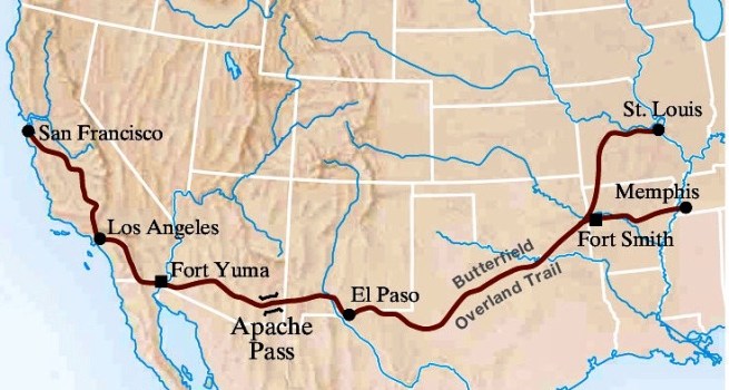
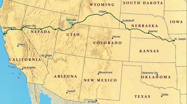
It took Butterfield over a year and a half to assemble the stations, coaches, horses, and drivers, but on September 15, 1858, the first of the regular bi-monthly Butterfield Overland Mail coaches set-off from St. Louis. No longer did mail between the two coasts have to sail to Panama (regular railroad service across Panama had begun in 1855) and back, but more to the point, as late as 1858, St. Louis in the center of the country, was still the preferred jumping-off point for the Pacific coast. But it was St. Louis’ last hurrah, for Chicago’s ever-expanding railroad web had finally crossed the Mississippi and a similar express mail service to Sacramento, CA, the Pony Express, was initiated on April 3, 1860. This presaged a change in the wind because its eastern terminus was not St. Louis, but St. Joseph, MO. While St. Joseph was only 75 miles north of St. Louis, it was connected via the Hannibal & St. Joseph and the Chicago. Burlington & Quincy Railroads to Chicago. For all but the cleaning up after, Chicago won the battle with St. Louis to become the center of the West. Boston’s perseverance in constructing T.H. Perkins’ “Railroad scheme,” a railroad to link Boston to the Pacific (and the “China Trade”) had succeeded, some thirty-two years after the first wooden tie for the Boston & Worcester had been laid. Perkins, however, didn’t quite live to see his vision competed; he had died in 1854.

8.13. THE ROUTE TO CHICAGO FROM THE EAST IS COMPLETED
The IC station in Chicago finally opened on June 12, 1856, poignantly only three weeks after the sack of Lawrence, KS. The IC was by then longest railroad in the world, and when combined with the other lines that connected to Chicago, made the city the hub of the largest network of railroad tracks in the U.S., if not in the world.
“In 1857 Chicago had nearly four thousand miles of railroad tributary to herself, and the joint earnings of the companies amounted to over eighteen and a half millions of dollars!… [at the time of] the Rockford Convention of 1847, Chicago had not a mile of road… by 1855 [it had] almost 3,000, while, within a period of two years more, another thousand was added to the three. The world had never before saw such a stride made towards commercial supremacy.”
This network linked the NorthWest not only to the East Coast, but also to the South and would allow Chicago to pull abreast of its two river city competitors to the south, Cincinnati and St. Louis, in terms of economic and political importance by the start of the Civil War. In 1848, when Ogden had placed his first wooden tie at Kinzie and Halsted, Chicago’s population was 20,023; in 1857, the city’s new railroads had assisted in the growth of its population to 93,000 (roughly four out of every five people on the city’s sidewalks had arrived since 1848). In 1857, there were four roads linking Chicago to the East Coast:
Michigan Southern and Northern Indiana
Michigan Central
Grand Trunk (through Canada, north shore of Lake Erie, bridge over Niagara Falls)
(the Pittsburgh, Ft. Wayne, and Chicago would be completed in 1858, making a connection with the Pennsylvania RR to Philadelphia -see Chap. 9)
There were six trunk lines leaving Chicago for the north, the west, and the south. Starting from the north and rotating counterclockwise:
Chicago & Milwaukee (see Chap. 9)
Illinois & Wisconsin
Galena & Chicago Union
Chicago, Burlington, and Quincy (using the tracks of the G&CU to/from Turner Junction)
Joliet & Chicago (see Chap. 9; it was reorganized in 1861 as the Chicago & Alton)
Chicago & Rock Island
Illinois Central
There were now five terminals in Chicago (that served these railroads). Starting from the north and rotating clockwise:
the Illinois & Wisconsin Station (I&W, C&M)
the Galena & Chicago Union Station (G&CU, CB&Q)
the Illinois Central Station (IC, MC)
the Chicago & Western Indiana-Dearborn Station (GT, Erie)
the Michigan Southern and Rock Island-La Salle Station (MS, C&RI, J&C)
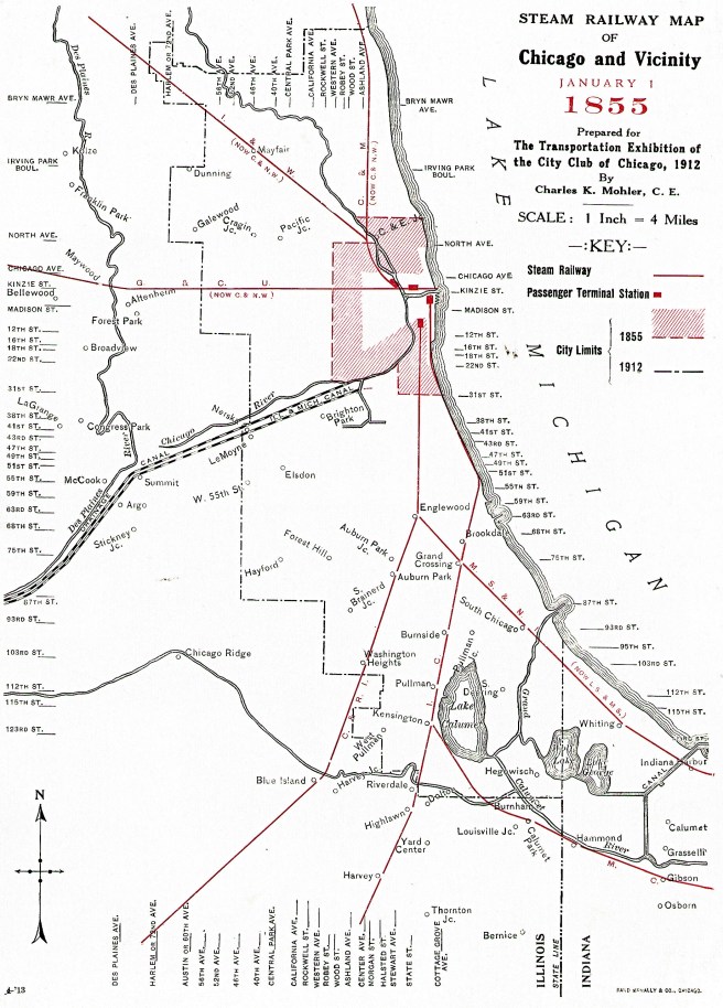
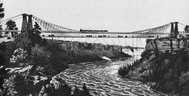
These were located strategically around the periphery of the business district, yet Common Council had not allowed one iron rail of the world’s largest railroad network to be laid within the 64-block grid of this district. By this date, the last link in the through route from Boston, John Roebling’s suspension bridge across the Niagara valley had been completed in March 1855, thereby completing the Great Western Railroad in Canada along the northern shore of Lake Erie between Buffalo and Detroit. It was now possible to board a Boston & Worcester train at State Street in Boston, and travel by railroad (except for a ferry across the Detroit River) to within a three block walk of State Street in Chicago:
“As we approached Chicago, the prairie subsided into swampy land, and thick belts of trees fringed the horizon; on our right glimpses of sea could be caught through openings in the wood – the inland sea on which stands the queen of the lakes. Michigan looks broad and blue as the Mediterranean. Large farmhouses stud the country, and houses which must be the retreat of merchants and citizens of means; and when the train, leaving the land altogether, dashes out on a pier and causeway built along the borders of the lake, we see lines of noble houses, a fine boulevard, a forest of masts, huge isolated piles of masonry, the famed grain elevators by which so many have been hoisted to fortune, churches and public edifices, and the apparatus of a great city. And just at nine o’clock the train gives its last steam shout and comes to a standstill in the spacious station of the Central Illinois Company, and in half-an-hour I am in comfortable quarters at the Richmond House.”
FURTHER READING:
Andreas, Alfred T. History of Chicago- vols. 1&2. Chicago, 1884-1886. Reprint, New York: Arno Press, 1975.
Borneman, Walter R., Iron Horses: America’s Race to Bring the Railroad West, New York: Back Bay, 2010.
(If you have any questions or suggestions, please feel free to eMail me at: thearchitectureprofessor@gmail.com)
