3.5. NEW YORK EXPERTISE AND CAPITAL ARRIVES IN CHICAGO: ARTHUR BRONSON AND CHARLES BUTLER

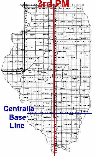
Following the death of John Kinzie in 1828, his heirs had established a pre-emptive claim in 1831 following the initial survey by James Thompson, to the 102 acres on the north side of the river in Section 10 where his house was located opposite Fort Dearborn. His younger son, Robert A. Kinzie, held a quarter interest in this land, even though his own store was on the west side.  He had traveled to New York City during the winter of 1832-33 to order merchandise for his store for the upcoming season, where he offered to sell his share of his father’s property to a complete stranger who just happened to walk into the store at that precise moment.  His name was Arthur Bronson, one of New York’s richest financiers, who had already heard the rumors about the region’s lush potential farmland.

The Erie Canal had opened the vast plains of western New York to farmers who were eagerly clearing and cultivating the newly accessed lands.  Unfortunately, the land that these farmers toiled over was owned not by them, but by three large land companies who had purchased this vast area from those who had been granted the original Dutch colonial land charters.  The land companies were trying to sell the land to the farmers to recoup their investments, but the financial instrument in use at the time was an installment contract that allowed the farmer to pay annual installments towards the purchase price, but the land company held the deed until the last payment.  As this was virgin land, the first years in which a farmer started to clear the land involved major start-up costs that meant there was little, if any profit with which to make the annual land payment.  The companies were trying to be sympathetic to the realities faced by the farmers by approving the non-payments, but the contracts stipulated that any unpaid interest was to be converted to principal, which then compounded the interest due the following year.  Therefore, as they tended their land year by year, they became more and more in debt, becoming virtually serfs to these companies. The result of this type of contract was that by 1829, over four years after the completion of the Erie Canal, not a single farmer in western New York owned the deed to the land that they had been working.

Charles Butler, a lawyer in Geneva, NY, had represented many of these farmers during these years, that had enabled him to develop a true sympathy for their plight. Butler was no mere backwoods attorney, but the younger brother of Benjamin Franklin Butler, the law partner of Martin Van Buren who in 1830 was the U.S. Secretary of State.  The Butler brothers had been born and raised in Kinderhook, NY, that was Van Buren’s hometown as well.  In fact, after finishing his law studies, Benjamin had clerked in Van Buren’s law office, and eventually became Van Buren’s right-hand man in the “Albany Regency” while the Senator was away in Washington.  Butler’s younger brother, Charles, after having finished his pre-law education, had clerked first for his older brother in Van Buren’s law office, and then for Van Buren himself, becoming an intimate friend of Van Buren’s family during this period.  The Butler brothers, Benjamin and Charles, in 1830, therefore, were close associates of Sec. of State Van Buren, who for all practical purposes was the third most powerful man in the U.S. government.

In early 1830, Charles had hit upon what at the time was a novel idea, but today is considered standard practice: to loan the farmers the money to buy the land using the value of the cultivated farmland as security for a mortgage.  Being intimately connected with Albany politics, Charles was aware that a new company, New York Life Insurance and Trust had been chartered in January 1830 by Isaac Bronson, a commercial banker who was one of the wealthiest men in New York City at the time, and his older son, Arthur, to provide the mortgage service of which his clients were in disparate need.  The Bronsons had intended the new company to be a more responsible investment alternative to the speculative investments that were quite common for the era, as they believed that commercial banks should be involved solely in investment loans. Butler’s civic mindedness took him to New York City to make his proposal to the Bronsons that seemed to fit their new business objectives perfectly.  The Bronsons understood not only the value of Butler’s farmers’ cultivated farmland, but also of Butler’s intimate political and personal connections with Van Buren who ran Albany’s politics, and agreed to Butler’s plan, hiring him to be their mortgage application agent in Geneva County, where he was responsible for arranging over $1 million in mortgages over the next five years.

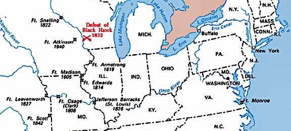
Some three years later in late 1832, Arthur Bronson had begun to hear of the stories about the Illinois territory from the soldiers returning from the Black Hawk War.  Bronson, who was an acquaintance of General Scott, sought out his recommendation about the area who confided that Chicago’s location would be very important in the future settlement of the West, no doubt confirming Bronson’s intuition.  In January 1833, while Butler was in New York City on regular business, Bronson broached the idea to his trusted mortgage agent that the two of them make a trip to Chicago that summer to evaluate the investment potential of the region.  Butler’s political value to Bronson had since increased with the 1832 Presidential election that resulted in the re-election of Pres. Jackson and saw Butler’s good friend Martin Van Buren elevated as Jackson’s Vice-President over the incumbent John C. Calhoun with a corresponding promising future for Butler and his brother as well.

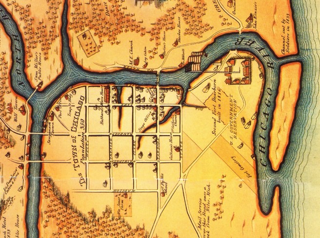
Only days after Bronson had suggested the trip to Butler, he was walking around New York City gathering information and chanced to visit the store of a supplier to Native traders, where he encountered Robert Kinzie, who made the offer to Bronson to sell his portion of his father’s land on the north side of the Chicago River if he was interested in the land when he saw it during his upcoming trip to Chicago.  Bronson and Butler departed on their journey in June 1833, and arrived at Chicago on August 2, only days before the local election that determined whether or not to incorporate the settlement as a town, to inspect the potential of the area and found:

“The present condition and prospects of Chicago… was, of course, the subject of constant and exciting discussion.  At this time, that vast country lying between Lake Michigan and the Mississippi River and the country lying northwest of it,… lay in one great unoccupied expanse of beautiful land… beautiful to look at in its virgin state, and ready for the plow of the farmer.  One could not fail to be greatly impressed with this scene,… and to see there the germ of the future, when these vast plains would be occupied and cultivated, yielding their abundant products of human food, and sustaining millions in population.  Lake Michigan lay there,… and it is clear to my mind that the productions of the vast country lying west and northwest of it on their way to the Eastern market… would necessarily be tributary to Chicago, in the site of which… the experienced observer saw the germ of a city, destined from its peculiar position near the head of the lake and its remarkable harbor formed by the river, to become the largest inland commercial emporium in the United States.”

It is important to point out that Bronson and Butler were not fly-by-night land speculators, but conservative, professional investment businessmen who had played pivotal roles in the economic success in western New York State that had been made possible with the construction of the Erie Canal. They were builders as much as they were investors.  

Chicago at the time of James Thompson’s survey of 1830. (Andreas, History of Chicago-I).

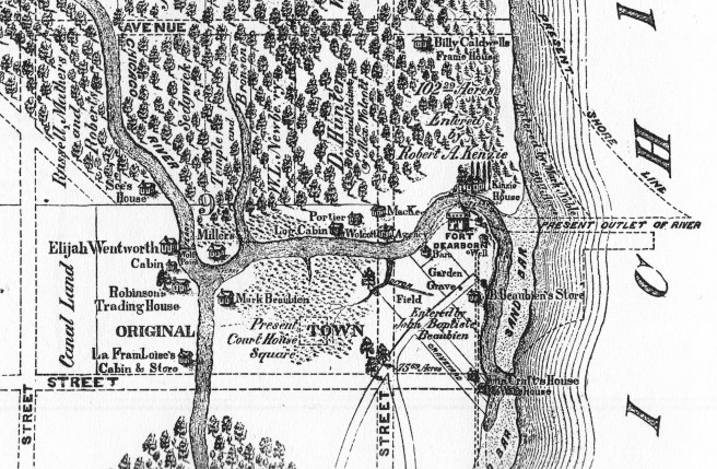
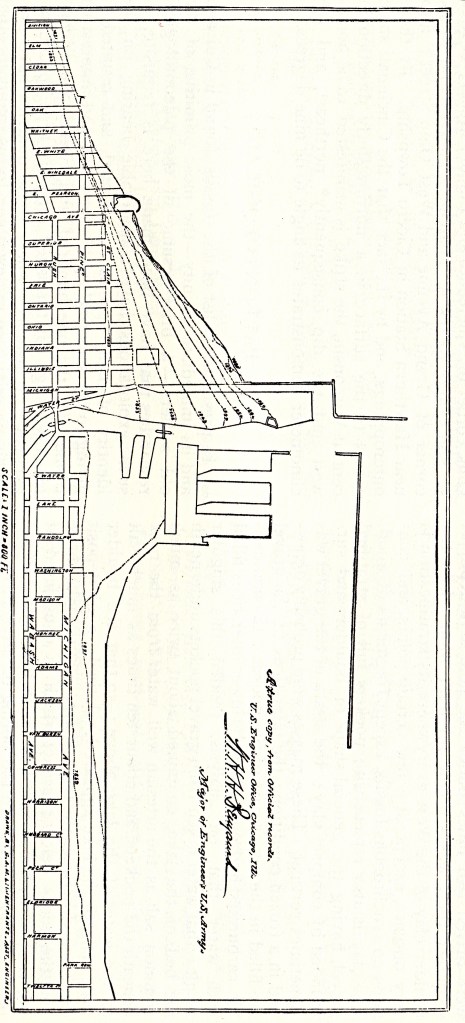
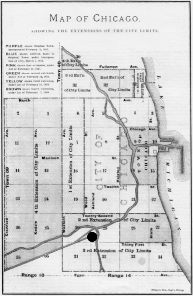
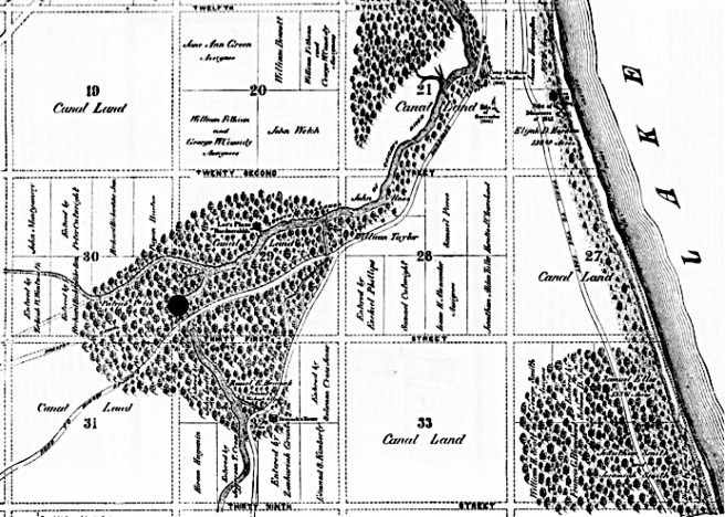
They inspected the Kinzie property, the northern portion of Section 10, bounded by the lake on the east, the river on the south, State Street on the west and Chicago Avenue on the north, but Bronson declined to purchase Kinzie’s quarter interest at this time because other parties still held a majority interest in the property.  Kinzie’s brother-in-law, Major David Hunter, not only held one-half interest in this property, but also owned 80 acres immediately adjacent to the west in Section 9, known as Wolcott’s (Dr. Alexander Wolcott had been the Indian Agent from 1820 to 1830) addition bounded by State Street on the east, Kinzie on the south, La Salle on the west, and Chicago on the north.  Bronson did eventually buy all of Hunter’s property, 182 acres along the northern bank of the river’s mouth, for $20,000 on Nov. 1, 1834, and hired local resident Walter L. Newberry to be his land agent.  Newberry was the younger brother Oliver Newberry, a wealthy Great Lakes shipping and Native supplies merchant from Detroit, who had sent George W. Dole to Chicago in 1831 to open and manage a store there.  Newberry had then sent his brother, Walter, to assist Dole in their company’s growing business.

Meanwhile, the 1833 land boom had become an explosion in October when the land in the School Section, Section 16, immediately to the south of Thompson’s original platted Section 9, that is bordered by Madison on the north, State on the east, Halsted on the west, and Twelfth (now Roosevelt) on the south, was put up for sale at public auction, bringing in a sum of $38,865.  An even greater investment potential, however, was about to become available immediately to the west of Chicago.  On September 26, 1833, the United Nation of Chippewa, Ottawa, and Pottawatomie Tribes had signed a treaty in Chicago that ceded to the Federal government all of their remaining lands east of the Mississippi River.  In exchange for the government’s promise to pay their living expenses for one year and $1 million for miscellaneous settlements, the Tribes had promised to move west of the Mississippi River within three years.  This action extinguished the last Native claim in northern Illinois and southern Wisconsin, and opened the area for white settlement, in which the government planned to start selling lots in May 1835. However, the ultimate removal of the Natives from Illinois also meant the end of the lucrative Native and fur trade that had sustained the area’s economy since its discovery by Europeans.  This economic loss would be more than offset in the immediate future, however, by the greater commercial potential in the sales of the newly vacated Tribal lands.

Canalport/Bridgeport the start of the Illinois & Michigan Canal, Ashland and 29th. (Andreas, History of Chicago-I)

Upon their arrival the two visitors from the East were quickly approached by Chicago’s leading businessmen regarding their recommendations concerning the funding and construction of the canal.  Perceiving that the commercial potential of the region revolved around the completion of the canal, Bronson, who had witnessed the construction of the Erie Canal and understood the potential profit to be gained not only in building the canal, but more importantly, also in speculating in the land immediately adjacent to this new capital improvement, shrewdly purchased 7,000 acres of land adjoining Canalport (its name was changed later to Bridgeport).  At this time support for the canal was still languishing in the Illinois legislature as there were those who were still arguing for a railroad over a canal, so the two New Yorkers provided appropriate assistance the following year in the presentation of a petition to the legislature that requested the incorporation of a new company to construct the canal.  The presentation of the Chicago canal petition in the General Assembly on November 5, 1834, reinforced the efforts of newly elected Governor Duncan, who was from northern Illinois and, fearing the potential monopoly of a railroad, was also an advocate of the canal.

FURTHER READING:

Andreas, Alfred T. History of Chicago, 3 vols. Chicago, 1884-1886. Reprint, New York: Arno Press, 1975.

Bernstein, Peter L. Wedding of the Waters: the Erie Canal and the Making of a Great Nation” New York: Norton, 2005.

Haeger, John Denis, “Eastern Financiers and Institutional Change: The Origins of the New York Life Insurance and Trust Company and the Ohio Life Insurance and Trust Company,” The Journal of Economic History, Vol. 39, No. 1, (March 1979), pp. 259-273. 

Harpster, Jack. A Biography of William B. Ogden. Carbondale: Southern Illinois University, 2009.

Howe, Daniel Walker.  What Hath God Wrought: The Transformation of America, 1815-1848. New York: Oxford University Press, 2007.

Pierce, Bessie Louis. A History of Chicago-1. New York: Knopf.  1940.

Stoddard, Francis Hovey, The Life and Letters of Charles Butler, New York: Scribner: 1903.

(If you have any questions or suggestions, please feel free to eMail me at: thearchitectureprofessor@gmail.com)

3.3. STALEMENT OVER THE CANAL

Gen. Scott had marched his troops from Fort Dearborn in the summer of 1832 through this fertile prairie that had now been opened for farming.  In the fall, these men had returned to their homes back east with glowing reports of the newly available land, initiating an intense land craze that had Chicago at its center.  Scott had returned home as well, having gained an appreciation for the water route from Buffalo to Chicago and the potential for a canal at the Chicago River. Echoing Cook’s claims made in Congress six years earlier that the canal would be invaluable in wartime, Scott recommended that the War Department take an active interest in getting the canal built.  Undoubtedly, this also strengthened the argument for improving the mouth of the Chicago River along the design proposed by William Howard in 1830 that called for a channel through the sandbar that would be protected by piers extended into the lake.  A young army engineer, Lt. Jefferson Davis, had been sent to evaluate the situation and had recommended this plan over the objections of those who favored the alternate improvement of the Calumet River to the south (where Redfield’s proposed railroad to the Mississippi was to pass by Lake Michigan before heading straight for Rock Island).  On March 2, 1833, Congress sided with Davis and voted $25,000 to cut the sandbar and erect the two piers as originally proposed three years earlier by Howard.

William Howard, Proposed improvements to the mouth of the Chicago River, 1830. (Sprague, JSAH, December 1981)

In the meantime, the canal issue had been thrown into complete chaos when on January 7, 1833, Chief Engineer Bucklin presented his final estimates for the three alternative schemes.  The estimate of the Chicago canal route at $4,107,440.43 was the highest of the three, while a similar canal that connected the Calumet River with the Illinois River would cost much less at $1,601,695.83.  However, Bucklin estimated the cost of a railroad over the Chicago route to be the least expensive at $1,052,488.19.  Bucklin’s study had obviously impressed Governor Reynolds, who foreshadowed Bucklin’s conclusions by telling the Illinois General Assembly on December 4, 1832, that the railroad was “the only practicable mode of connection.”  That body, however, was unable to resolve the issue and later in March 1833, following Congress’ appropriation for harbor improvements, abolished the canal commission altogether and repealed all acts passed since 1829 that pertained to the canal’s construction.  The final cost estimate of over $4 million was viewed as too high for the state to undertake on its own.  More resources would have to be procured from the Federal government in addition to the recently approved $25,000, if construction of the canal was ever to begin.  The State could not afford or was unwilling to appropriate the amount Bucklin had estimated and decided to hold their cards, wanting Jackson and the Federal government to make the next move.  The project was purposefully stalled for the next two years, even as public anticipation of the project fed the nascent town’s population and corresponding demand for land.  Nonetheless, Lt. Davis completed the two piers later that year, extending the northern pier some 1000’ into the lake in an attempt to overcome the strong lake current from reforming the sandbar at the mouth of the river.   But it would be a continuous struggle to keep the river’s mouth clear of new sandbars that were created by the lake’s strong current that formed against the back of the new north pier until its end was reached and then the current would simply begin to silt up the mouth once again, forcing the pier to be extended a little farther north each time in response to the latest sandbar.  

Map showing the growth of the sand deposits against of the north pier. (Andreas, History of Chicago-I)

3.4. THE TOWN OF CHICAGO

The Illinois legislature had passed an act on February 12, 1831, that clarified the process that a group of people living within the general proximity of each other would have to follow in order to incorporate as a formal town with all of the concomitant legal rights and responsibilities.  The most significant requirement to meet was a minimum population of 150.  If a majority of residents approved of such incorporation at a public meting, an election was to be held five days from when that decision had been approved in order to elect the new town’s five Trustees. During the spring and summer of 1833, immigration in anticipation of the first sale of the canal’s landgrant had more than doubled the area’s population to approximately 350, more than sufficient to qualify to organize under a town charter. On August 5, 1833, a public meeting was held at which an election was held that approved (by a vote of 12-1) to incorporate the Town of Chicago.  On August 10 an election was held at the Sauganash Inn that elected the town’s five trustees as George W. Dole, Madore B. Beaubien, John Miller, E.S. Kimberly, and T. J. V. Owen as the Board’s first President.

FURTHER READING:

Andreas, Alfred T. History of Chicago, 3 vols. Chicago, 1884-1886. Reprint, New York: Arno Press, 1975.

(If you have any questions or suggestions, please feel free to eMail me at: thearchitectureprofessor@gmail.com)

CHAPTER 3. FROM PLATS IN A MARSH TO A CITY (1831-1837)

3.1. THE BLACK HAWK WAR

The problems with the Chicago canal were only compounded in the spring of 1831.  Tensions began to mount when a band of Sauk Natives led by the warrior Black Hawk, returned to their village, Saukenuk, near Rock Island from winter hunting in Iowa, seeking refuge from Sioux warparties only to find white squatters living in their lodges in what the Natives viewed as a direct violation of the Treaty of 1804.  The Federal government, on the other hand, had sold the land under the village to white settlers and, in its interpretation of the treaty, the withdrawal of the Natives was dictated.  Infantry from St. Louis temporarily quelled the situation and forced the Sauks to sign a new treaty requiring them to retire west of the Mississippi but without the season’s crops they normally would have harvested.  Their distress had been compounded by a poor winter hunt that had left the starving Sauk with little alternative but to try to return to their former home.  The following spring on April 5, 1832, the Winnebago prophet White Cloud visited Fort Armstrong and informed government authorities that the Sauks led by Black Hawk, were going to recross the Mississippi and join White Cloud’s village in northern Illinois, thereby defying the treaty signed just the previous year.

Map Showing Location of Fort Armstrong, Saukenuk, and Black Hawk’s retreat to Bad Axe. (Online)

Following the killing of three of Black Hawk’s emissaries, who were seeking a peaceful resolution, on May 12, 1832, the Natives broke into smaller warparties bent on revenge and wreaked havoc throughout northern Illinois.  Rightfully fearing for their lives, white settlers fled the area for the relative safety of Fort Dearborn that at the time had fortunately been abandoned by its garrison.  Fortunately, because the population at the fort was to increase five-fold by the end of May, swelled by over 400 refugees who were able to take shelter in or near the vacant barracks.  Once the fort was filled, latecomers were forced to hastily erect temporary shelters with whatever materials were readily available.

While over 4,000 local militia, regulars, and volunteers pursued Black Hawk up the Rock River, the Federal government shipped additional troops, under the command of General Winfield Scott from Buffalo to Fort Dearborn.  Unfortunately, when these men finally arrived on July 10, they presented an even greater threat than did the Natives: cholera.  Once word of the shipboard menace got out, the fort emptied even faster than it had filled.  Around midnight, one of Scott’s officers ordered the fort’s remaining civilian occupants to evacuate before morning, when the infected soldiers would be moved into the fort.  The ensuing panic sent the refugees once again desperately in search of shelter:

“The next morning in vain did we seek for a house.  A rail fence was, however, in sight.  Into one corner I moved.  A few boards made the floor.  Carpet kept off the wind from our heads and backs.  Other boards formed a far from water-proof roof.  Here we remained three days and nights, cooking on the ground… After three days Captain Johnson and my husband secured a lot of green lumber.  In sight of our fence stood the frame of a house.  To this the green boards were soon nailed and a temporary partition put in.  Here our two families moved.

In the ten days that it took the soldiers to recover, over 100 had died.  By the time the surviving troops had finally set out for the Rock River, the local troops from Fort Armstrong had already caught up with and cornered the main body of Natives trying to recross the Mississippi at the Bad Axe River in southern Wisconsin and massacred over 150 Natives on August 2, 1832.  Hostilities were formally ended with the signing of a treaty on September 21, that set a deadline of June 1, 1833, for the final withdrawal of the Sauks to land west of the Mississippi.

3.2. JACKSON’S WAR ON THE SECOND BANK OF THE U.S. AND THE SPECULATION BUBBLE

Pres. Jackson used his upcoming 1832 re-election campaign as a plebiscite on the value of the Second Bank of the U.S. that, even though it had a rocky beginning after its 1816 charter, had by 1832 calmed down the national economy and had stabilized the country’s currency.  (Based on Hamiltonian principles of a strong, national government, the 2BUS was a political lightning rod in the country’s mounting Sectionalist politics for strict constructionists argued that there was no provision in the Constitution for the Federal government to establish such an institution.) In fact, buoyed by the 2BUS’s recent policies and by increased land sales, the Federal government made the final payment of the Federal debt in January 1835 that had left Congress somewhat in a quandary regarding what to do with the burgeoning inflow of money coming from the sale of Federal lands.  Congress passed the Specie Distribution Act of 1836 specifically to “spread the wealth” to the states to be used for internal improvements as they deemed best (without any Federal centralized planning, Jackson’s bogeyman).  

Nonetheless, Jackson viewed the 2BUS as an institutional threat to his personal authority (the President had no control over its patronage positions) and had used Populist reaction against the 2BUS and the marked failure of the issuance of paper currency as political issues to win his re-election in 1832, after which he had embarked on a program to destroy the bank by denying the renewal of its charter due in 1836.  Jackson eventually settled on a policy that was questionable in its legality: stopping all further deposits of Federal revenues in the Bank in order to weaken its power.  However, he had to first go through three Secretaries of the Treasury before he found one, Roger Taney who at the time was also the Attorney General. to implement his plan.  This new banking policy had the added bonus, utilizing Van Buren’s patronage process by distributing these funds into initially seven (whose number eventually grew to over ninety) “pet” banks that were, not so coincidentally, all owned by Democratic Party stalwarts.  The reduced power of the 2BUS to control the money supply, combined with the infusion of Federal monies that became available once the Federal debt was paid off, into “less-principled” regional banks resulted in an explosion of paper currency that had unleashed a frenzy of real estate speculation that was slowly resulting in inflation of the dollar and an economic bubble.

FURTHER READING:

Anderson, Frederick K., Joined By a River: Quad Cities, Rock Island, 1982.

Andreas, Alfred T. History of Chicago, 3 vols. Chicago, 1884-1886. Reprint, New York: Arno Press, 1975.

(If you have any questions or suggestions, please feel free to eMail me at: thearchitectureprofessor@gmail.com)

2.5. THE CENTRAL RAILROAD: THE ST. LOUIS CUT-OFF

Meanwhile, within a year of Bucklin’s having been given his task to cost out the canal options in 1831, the first proposal for a railroad in Illinois surfaced in the Illinois legislature.  However, the proposal was not an alternative to the canal, but one that aimed at strengthening the chances of the canal’s success. Illinois’ Lieutenant Governor A. M. Jenkins foreshadowed the coming battle between St. Louis and the yet-to-be chartered town of Chicago by proposing what was to become referred to as the “St. Louis Cut-off:” a “Central” railroad from the end of the canal at La Salle straight south through the center of the state to the junction of the Mississippi and Ohio Rivers.  St. Louis’ location at the junction of the Mississippi, Missouri, and Illinois Rivers had naturally allowed it to become the economic capital in the trans-Mississippi Valley as it was much less expensive to travel and ship goods to the Atlantic seaboard via the Mississippi downriver to New Orleans than it was either overland or via the Ohio River upriver to Pittsburgh and then overland to the Atlantic.  Therefore, the majority of Illinois’ early settlement had economically gravitated toward St. Louis.  St. Louis’ economic position would be vastly enhanced with the construction of the Illinois & Michigan Canal, for the Illinois River joined the Mississippi at Alton, IL, just upriver from St. Louis.  Great Lakes traffic via the Illinois River, therefore, destined either for the West would have to pass St. Louis on its way to the Missouri River, or for the South would have to pass St. Louis on its way to Memphis or New Orleans.  Hence, St. Louis’ political leaders had all thrown their support behind the Federal improvements of the Chicago canal.

The first proposed route for the Central Railroad started at the end of the planned Illinois & Michigan Canal at La Salle (top dot) and ended at the confluence of the Ohio and Mississippi Rivers (lower dot). (Online)

Thus, the proposed canal presented a political problem for those politicians who wanted to unify the new state, for the presence of St. Louis tended to divide Illinois into the southern half that naturally gravitated toward St. Louis (and was pro-slavery), and the emerging northern half that in the western portion centered around Galena, that although being larger than St. Louis, was still dependent on St. Louis’ connections with New Orleans as it shipped its lead down the Mississippi.

The politicians whose goal was to build Chicago and its canal as a political counterbalance to St. Louis in the northeastern portion of Illinois, therefore, eventually had to trick St. Louis into supporting the canal, and then stab its older competitor in the back by building an alternative means of transporting goods in the southern half of the state.  Water in a canal has no current, however, and once having secured St. Louis’ support in gaining the Federal aid, Illinois’ leaders now began their campaign to bypass the river city’s central position in the region by diverting traffic away from St. Louis with the proposed Central Railroad, and thereby reroute the state’s inland traffic either north through the Chicago canal or south via the proposed railroad to Cairo (at the junction of the Ohio and Mississippi Rivers).  Thus, the Central Railroad was planned to gain more Downstate legislative support for the canal scheme, that up until this time had been viewed as one that would benefit only the northern half of the state.  Lacking initial support, however, the Central Railroad proposal would lay dormant for three years, until a political compromise would finally break the political logjam over the construction of the canal.

FURTHER READING:

Andreas, Alfred T. History of Chicago, 3 vols. Chicago, 1884-1886. Reprint, New York: Arno Press, 1975.

Fergus, Robert, Fergus’ Historical Series, No. 18: Chicago River – And – Harbor Convention, Chicago, 1882.

(If you have any questions or suggestions, please feel free to eMail me at: thearchitectureprofessor@gmail.com)

2.4. THE CINCINNATI & CHARLESTON RAILROAD

The feasibility of constructing a railroad to span such distances was being proven as the longest route in the world at this moment was about to be completed in South Carolina by Horatio Allen.  On October 3, 1833, the South Carolina Canal & Railroad made its first run along its 136-mile-long route between Charleston and Hamburg, on the Savannah River.  By then, the company’s management had already begun exploring the possibilities of extending their route to the Ohio River to extend Charleston’s inland market in an attempt to make Charleston the major Atlantic port.  These events in Charleston did not go unnoticed in the West’s largest city, Cincinnati.  By this time the State of Ohio had embarked on an aggressive canal building campaign ignited by the success of the Erie Canal.  In 1832 it had completed the Ohio & Erie Canal that linked Cleveland on Lake Erie to the Ohio River at Portsmouth, OH, a 308-mille route that was nearly as long as the Erie Canal’s.  In 1829, construction had started on the second phase of the state’s canal system, the Miami & Erie Canal, eventually completed in 1845 along a route that would link Cincinnati on the Ohio River with Lake Erie at Toledo.  For Cincinnati, already enjoying the commercial trade along the Ohio River as well as from inland Kentucky communities along the Licking River that emptied into the Ohio across from it, the new canal promised more trade from inland Ohio as well as from Lake Erie that would only enhance the city’s premiere position in the West in its competition with neighboring Louisville (in 1830, the populations of these cities were as follows: Cincinnati-24,831, Louisville-10,341, Galena-10,000+, St. Louis-5,882, Chicago-40).

Ohio’s two central canals. (Online)

But the railroad was “in the air” and Ebenezer Thomas, the editor of the Cincinnati Daily Evening Post, had been promoting the idea of a railroad from Cincinnati to Charleston to open up new markets in the southeast as well as to give the city a direct outlet to the Atlantic.  Thomas had moved to Cincinnati in 1829 from Charleston, where he had first been exposed to Stephen Elliott’s proposal to build a line to the Mississippi.  Thomas’ proposal was adopted by one of Cincinnati’s patricians, Dr. Daniel Drake, responsible for the founding in 1819 of Medical College of Ohio, the first medical School west of the Appalachians, among his many other accomplishments.  At a meeting in Cincinnati on August 10, 1835, Drake proposed the idea of building a railroad from the Kentucky bank of the Ohio River, across from Cincinnati to connect with the SCC&RR as the final link to Charleston.  Drake clearly stated the economic and political advantages of joining the NorthWest to the South that were isolated from each other by the Appalachian Mountains to the south of the Ohio River by breaking through at the Cumberland Gap: “The north and the south would, in fact, shake hands with each other, yield up their social and political hostility, pledge themselves to common national interests, and part as friends and brethren.”  The Cincinnati group followed up with the appointment of a Standing Committee of Correspondence, charged with eliciting support for the proposal throughout the effected region.  For publicity reasons, the Committee was headed by the NorthWest’s war hero, William Henry Harrison, who had led American troops in the defeat of the British and their Native allies at the 1813 Battle of Moraviantown, and thereby, secured the NorthWest from any further British incursions during the War of 1812, but the workhorse of the group was, of course, Drake.

Drake’s equivalent in Charleston was former U.S. Senator Robert Young Hayne, one of Charleston’s ablest politicians who at this time was the city’s mayor.  The city’s Chamber of Commerce met on Oct. 22, 1835, to endorse the Cincinnati proposal, after which Hayne took control of the city’s involvement:

“We can almost perceive the finger of heaven pointing to the barriers which have long separated them [West and South], and reverently think we HEAR THE VOICE OF GOD, [capitals are original] speaking through his works, commanding us to remove those obstacles, and encouraging our exertions, by the promise of abundant blessings, with which a wise and beneficent Providence, seldom fails to regard the faithful efforts of his children.”

Following Cincinnati’s lead, the Charleston group also appointed a standing committee that undertook two important processes.  First, they pushed for the chartering of the Cincinnati & Charleston Railroad in the states through which the route would pass: South Carolina, North Carolina, Tennessee, and Kentucky, and by March 1836 all four states had done so.  The irony was that Ohio, the state that probably stood to gain the most through the continued growth of Cincinnati’s economy, refused to do so, claiming the potential damage that such a railroad might have on the state’s other internal improvements.  Advocates of Cincinnati’s competing neighbor, Louisville, however, had also made Kentucky’s legislature hold out for the concession of a branch of the road to end at Louisville, which the railroad’s supporters not only agreed to, but to assure continued support from the Blue Grass state, wisely revised the company’s name to the Louisville, Cincinnati & Charleston Railroad.  Second, the Committee arranged for surveys for the route, paid for by a $10,000 appropriation by the South Carolina legislature, to be conducted by Capt. William G. Williams and Col. James Gadsden, South Carolina’s chief engineer.

Map showing the proposed route of the Louisville, Cincinnati & Charleston Rail Road. (Grant, The LC&C RR)

A convention, the Great Southern Railroad Convention was held in Knoxville, TN, midway between the two planned termini on July 4-8, 1836, to discuss the next steps, which was attended by 380 delegates, the largest railroad convention ever to gather in the antebellum South.  Hayne was unanimously elected to be the company’s president, while he also joined Drake among those who sat on the all-important Committee of Forty-Five that hammered out the important details.  Considering the potential conflicts, the event ended quite harmonious with the exertion that all involved should move forward with the greatest of speed. Pres. Hayne at once began the campaign to secure the $4 million in stock subscriptions needed to incorporate the company.  Meanwhile, Cincinnati looked forward to the completion the road, anticipating even greater economic results for its businesses and civic status…

FURTHER READING:

Grant, H. Roger. The Louisville, Cincinnati, & Charleston Rail Road. Bloomington: Indiana University Press, 2014.

(If you have any questions or suggestions, please feel free to eMail me at: thearchitectureprofessor@gmail.com)

2.3. EARLY PROPOSALS FOR A TRANSCONTINENTAL RAILROAD

Map showing the 1828 proposed route of the Louisville, Cincinnati & Charleston Rail Road. (Grant, The LC&C RR)

Although John Stevens in 1823 had been the first to project a system of interstate railroads that connected the Atlantic seaboard with the trans-Appalachian hinterlands in order to maintain Philadelphia’s national economic hegemony, it did not take long for business leaders from the other Atlantic ports, especially once the impact of the Erie Canal had been fully digested, to follow-up with their own proposals.  Following the chartering of the South Carolina Canal & Railroad, Stephen Elliott, the president of Charleston’s South Carolina State Bank had proposed in 1828 that its route be extended to the confluence of the Ohio and Mississippi Rivers (there would not be a chartered settlement at this location until 1836 that would then be named Cairo, IL) in an attempt to divert from New Orleans the agricultural products beginning to come from the burgeoning West in order to make Charleston the major Atlantic port.   In the following year, 1829, New Yorker William C. Redfield also made a proposal to build an interstate railroad from the Atlantic to the Mississippi River in a pamphlet he later titled Sketch of the Geographical Rout [sicof a Great Railway by Which It Is Proposed to Connect the Canals and navigable Waters of New-York, Pennsylvania, Ohio, Indiana, Illinois, Michigan, Missouri, and the Adjacent States and Territories:   

“A Great Railway by which it is proposed to connect the canals and navigable waters of New York, Pennsylvania, Ohio, Indiana, Illinois, Michigan, Missouri, and the adjacent States and Territories, opening thereby a Free Communication between the Atlantic States and the Great Valleys of the Mississippi…  This great plateau will, indeed, some day be intersected by thousands of railroad communications, and so rapid will be the increase of its population and resources that many persons now living will probably see most or all of this accomplished.”

Redfield’s planned route from New York City went first to Buffalo (to link with the Great Lakes) and then hugged the southern shore of Lake Erie until it broke straight west along the 42nd parallel through Northern Indiana to the mouth of the Calumet River at the southern-most tip of Lake Michigan.  From there it logically headed west through Illinois to Fort Armstrong on Rock Island, a location that suggested bridging the Mississippi because the span to do so at this point was one of the shorter distances along the length of the river due to the position of the island in the river. 

Location of Fort Armstrong on Rock Island. Redfield’s proposed route ran from New York City, to Buffalo, around the south edge of Lake Erie, straight to the southern tip of Lake Michigan at the Calumet River and then on to Rock Island. There was no Chicago in 1829. (Online)

Interestingly, the Federal government at this time had just begun to use the loophole it had written into the 1804 Treaty of St. Louis by selling “its Land” north of the Indian Boundary line to private owners.  This opened the way to remove the remaining Natives from the land east of the Mississippi in northern Illinois and southern Wisconsin.  Therefore, Rock Island, located at the center of approximately 1,200 miles of navigable waterways throughout the growing NorthWest, seemed to be an appropriate termination for Redfield’s Great Railroad. When Redfield had surveyed the route in 1829, there was no Chicago to the north of the Calumet River to warp his westward route inefficiently to the north. (Inspired by Redfield’s proposal and Jervis’ completion of the Mohawk & Hudson in 1831, a series of ten railroads would be constructed between 1831 and 1842 that linked Albany to Buffalo, essentially paralleling the Erie Canal, that would eventually be merged in 1853 into one company, the New York Central Railroad.)

Map of the Railroads that Formed the “Central” Railroad System in New York State.  (Men and Iron: A History of the New York Central)

In February 6, 1832, the Ann Arbor (MI) Emigrant published an article (probably written by its publisher, Judge S. W. Dexter) in which the author proposed to extend Redfield’s interstate route (including Redfield’s bypassing the mouth of the Chicago River) into a full-fledged transcontinental railroad to the Pacific Coast (that would be the actual route used by the Union Pacific some thirty years in the future):

“The distance between New York and Oregon is about three thousand miles.  From New York we would pursue the most convenient route to the vicinity of Lake Erie, thence along the south shore of this lake and of Lake Michigan, cross the Mississippi between forty-one and forty-two of the north latitude, cross the Missouri about the mouth of the Platte, and thence to the Rocky Mountains, near the source of the last named river, thence to Oregon, by the valley of the south branch of that stream, called the southern branch of Lewis’ River.”

This was written three months before Capt. Bonneville struck out from Independence, MO, hoping to blaze what would becalled the Oregon Trail. Another claimant to being the first to propose a transcontinental railroad was Dr. Hartwell Carver of Rochester, NY, who submitted a similar proposal to Congress for such a road later in 1832.

FURTHER READING:

Anderson, Frederick K., Joined By a River: Quad Cities, Rock Island, 1982

Harlow, Alvin F. The Road of the Century. New York: Creative Age Press, 1947.

Williams, John Hoyt. A Great and Shining Road-The Epic Story of the Transcontinental Railroad. Lincoln: University of Nebraska Press, 1989.

(If you have any questions or suggestions, please feel free to eMail me at: thearchitectureprofessor@gmail.com)

2.2. MOVING BEYOND ST. LOUIS: THE OREGON TRAIL

Meanwhile, during the intervening period between Lewis and Clark’s expedition to the Oregon country in 1803 and the Illinois’ legislature’s charge to Bucklin in February 1831, a clearer understanding of the geography that lay between the Mississippi River and the Columbia River basin in Oregon (remember, Mexico still controlled California) had begun to emerge, Perhaps the most important discovery, especially to the future interests of Chicago, was made in 1812, when a group of seven employees of John Jacob Astor’s ill-fated Pacific Fur Company who were retreating from the highly vulnerable Fort Astoria at the mouth of the Columbia River at the Pacific Ocean at the start of the War of 1812, discovered the South Pass in the Rockies in what is now southwestern Wyoming, that led to the Platte River, that they then followed to the Missouri River, eventually arriving at St. Louis.  South Pass turned out to be the lowest point of elevation crossing the continental divide, which together with the close proximity of the Sweetwater River (a branch of the N. Platte), made this route the easiest to traverse from the Mississippi Valley through the Rockies.  As far as Chicago’s long-term prospects, the South Pass was located along the 42° parallel, in a straight (railroad) line due west of Chicago, while St. Louis was over 200 miles south of the South Pass. 

The Oregon Trail. Note that South Pass is at the same latitude as is Chicago, whereas St. Louis is some 200 miles to the south. (Online)

The end of the War of 1812 had simply returned the status quo of the stiff competition between British and American fur traders to the upper portions of the Louisiana Purchase, but through the lobbying of Astor, Sec. of War Calhoun had been convinced of the need for another Federal expedition, to erect a series of military “outposts” along the northern reaches of the Missouri River. The Federal government commissioned five more military expeditions into the Spanish Southwest as well as the Northwest, that followed prior to 1820.The largest of these military expeditions occurred in the fall of 1818, when Calhoun had authorized what would be known as the Yellowstone Expedition led by Col. Henry Atkinson to explore the Missouri up to the mouth of the Yellowstone River. 

A scientific contingent that was to parallel Atkinson’s troops was led by military engineer Maj. Stephen H. Long, who had earlier conducted the first survey of the mouth of the Chicago River.  They departed from St. Louis in May 1819 in the first steam-powered riverboats used west of the Mississippi but got no farther than the mouth of the Platte River, known as Council Bluff at the time as Lewis and Clark had used the location to meet with the local natives at the start of their expedition. The winter of 1819/20 was particularly harsh, and then followed by the spring flooding of the Missouri, the troops were forced to build a fort atop Council Bluff, which they named Fort Atkinson, in honor of their colonel.  The primary reason for the failure of this mission was the government’s inability to supply troops for extended periods over such long distances, a problem that would vex such attempts, be they military or civilian, to penetrate the West for the next twenty-five years.

The failure of the mission, nevertheless, did not stop the Federal government from gathering information about the coveted lands west of the Mississippi.  In May 1820, Maj. Long was assigned to lead an expedition to up the Platte River to the Rocky Mountains and then reconnoiter the newly-agreed border with New Spain along the 42° parallel.  Upon his return, Long produced the first accurate map of the region in which he had located what he named “the Great Desert,” that “is frequented by roving bands of Indians who have no fixed places of residence but roam from place to place in quest of game.”  Long had identified the challenge in reaching the Pacific over a land route with limited supplies of water and timber.  Hemmed in by the Spanish to the south and the British in the north, Americans would have to find a route to the Pacific through what would be initially referred to as “The Great American Desert.”  

Map of the Region explored by Maj. Stephen H. Long, 1822. Note the designation, “Great Desert” marked in the lower left corner. (Online)

Thomas Hart Benton in his St. Louis Enquirer had continued during the early 1820s to encourage the efforts of the local fur trappers and traders commonly referred to as “mountainmen,” the most famous of which was Jedediah Smith, to continue to push ever farther up the Missouri and Platte Rivers, to explore the region in search of the most expedient route to the Pacific.  Unfortunately, the Native tribes of the Blackfeet and Arikaras along the upper Missouri route stood their ground, forcing these explorers to try the Platte River valley to the Central Rockies.  In 1823, a St. Louis fur trader, W.H. Ashley, followed the Sweetwater and rediscovered the South Pass, establishing the general route to the Pacific between British Canada (the 49° parallel) in the north and Mexico (the 42° parallel) to the south for what would be known as the Oregon Trail.  Benton’s Enquirer celebrated the discovery of the path to the Pacific: from St. Louis to the “river Platte a short distance above its junction with the Missouri, (it) then pursues the waters of the Platte to their sources, and … crosses the headwaters of what Gen’l Ashley believes to be, the Rio Colorado of the West, and strikes for the first time, a ridge… running from north to south.  This, however, presents no difficulty, as a wide gap [the South Pass] is found.”  Benton’s route to the Pacific was thus discovered, with the first trader wagon train to make this voyage, financed by Astor and under the command of Captain Benjamin Bonneville, had departed in 1832.  The jumping-off point from the Missouri River for the Oregon Trail was the same as that for the Santa Fe Trail, Independence, MO.  Anyone wanting to travel overland to the Pacific would start at St. Louis, and take the Missouri River to Independence, where one would outfit the necessary wagon required for the remainder of the trip overland to either Oregon or Nuevo México:

“On the mighty Mississippi, below the mouth of the vast extended Missouri, draining a country of unrivalled productiveness… capable of sustaining a population as dense as almost any region of the globe… While just above enters the Illinois, draining the very heart of that most productive State – while to the north… the states of Iowa and Wisconsin – the northern part of Illinois and Minnesota, each of them destined to sustain millions… of agriculturalists and mechanics, will always have their natural markets at St. Louis.

The pre-railroad routes to the West. The Oregon and Santa Fe Trails converge at Independence, MO, and then on to St. Louis. Note that Chicago isn’t even on the map. Nauvoo (home of the Mormons) is now the largest city in Illinois, with Galena falling to second, showing the early influence of the Mississippi on Illinois. (Online)

The development of the Oregon Trail, in conjunction with the Santa Fe Trail, therefore, seemed to codify Benton’s vision of St. Louis’ centrality in the American West.  That is, as long as water travel was the only mode of travel from the East, but fortunately for the future prospects of Chicago, the South Pass was located along the 42° parallel, in a straight (railroad) line due west of Chicago, while St. Louis was over 200 miles south of the South Pass.

Further reading:

Primm, James Neal. Lion of the Valley: St. Louis, Missouri, 1764-1980 (3rd ed.). Missouri Historical Society Press, 1998.

(If you have any questions or suggestions, please feel free to eMail me at: thearchitectureprofessor@gmail.com)

CHAPTER 2. CANAL VS. RAILROAD? (1831-1837)

The Illinois’ legislature’s charge in February 1831 to Bucklin to investigate the cost of building a railroad rather than a canal to link the two rivers at Chicago was not as bold as it might first appear, because at least eight railroads had already been chartered and were in various stages of construction in the U.S. by then.

Fig. 2.1. East Coast of U.S. locating the major cities where railroads were being discussed in 1831: Boston, New York, Philadelphia, Baltimore, and Charleston. (Online)

2.1. THE FIRST AMERICAN RAILROADS

Railroads pulled by draft animals had been in service in Europe to assist mining operations for decades before British engineer Richard Trevithick applied the new technology of steam power to build the first moving steam engine or “locomotive” that pulled a combined load of freight and passengers ten miles in Wales on February 21, 1804.  (See Chapter 8 for Trevithick’s proposed 1000’ iron tower in 1833.)  The first steam-powered railroad, the Stockton & Darlington Railroad, powered by Locomotion, the first of many steam-powered locomotives designed by engineer George Stephenson had had its inaugural run on September 27, 1825.  These pioneering experiments in Great Britain were eagerly followed by Americans interested in applying this technology in the U.S., where horse-drawn railroads also predated the first steam railroads.  The first documented American horse-drawn company, the New Jersey Railroad Company was chartered on February 6, 1815, in New Jersey some ten years after Trevithick’s invention by Col. John Stevens, a lawyer and engineer who lived in what is now Hoboken, NJ, to create a land link between Philadelphia (at Trenton, NJ on the Delaware River) and New York City (at New Brunswick on the Raritan River).  The impending completion of the Erie Canal a decade later, however, was changing the economic calculus along the Eastern seaboard in favor of New York City, whose economy was beginning to overtake that of Philadelphia as the country’s financial center.  Stevens, America’s pioneering railroad visionary who was responsible for many inventions, including the country’s first steam-powered locomotive, eventually also succeeded in having the Pennsylvania legislature charter a second railroad on May 13, 1823, to run between Philadelphia to Columbia, PA, on the Susquehanna River, just upriver from Harrisburg, the state’s Capital.  Stevens had foreseen the potential of the railroad as Philadelphia’s salvation in its struggle to keep the Erie Canal and New York City at bay, and therefore, Stevens’ ultimate objective was nothing short of a vast interstate network of railroads that emanated from Philadelphia in order to maintain Philadelphia’s standing as the country’s largest city and financial center: 

“And when this great improvement in transportation shall have been extended to Pittsburgh, then thence into the heart of the extensive and fertile State of Ohio, and also the great western lakes, Philadelphia may then become the grand emporium of the western country… The improvement, when once introduced, will unquestionably be extended from Philadelphia across New Jersey to the city of New York.”

To prove the feasibility of a steam railroad, Stevens in 1825, the same year that Stephenson’s Locomotion pulled the first train in Britain, built a small steam-powered train that ran on a circular track on his Hoboken estate.  But he was fighting a very uphill battle because canal interests throughout Pennsylvania, inspired by the imminent completion of New York’s Erie Canal, would see to it that Pennsylvania would lag behind its competitors in the adoption of the railroad with the legislature’s passage of a series of bills in 1826 that formed the state’s Main Line of Public Works that called for a system of canals to link Philadelphia with Pittsburgh, and thus, via the Ohio River, to the NorthWest.  Railroads would eventually be incorporated into the system, but only as a means of linking one canal to another. 

Although Stevens was the first American to follow British’s railroad experiments, It took only three months after the start of Stephenson’s Stockton & Darlington for George Featherstonhaugh, a British immigrant who also was a follower of Stephenson’s work, who lived in upstate New York near Schenectady, to publish an announcement on December 28, 1825, stating that he planned to apply for a charter to build a railroad from Albany to Schenectady on the Mohawk River.  Although the New York legislature finally granted the charter for the Mohawk & Hudson on April 17, 1826, canal interests and Albany boosters fearing the proposal, added enough prohibitive provisions to it that, for all practical purposes, the project was stillborn for the foreseeable future.  While the New York legislature had debated Featherstonhaugh’s proposal. The Massachusetts and Pennsylvania legislatures had each approved a railroad charter in their respective states.  On March 4, 1826, the Massachusetts legislature approved the third American charter to build a railroad (although it, too, was to be horse-drawn) in the U.S., the Granite Rail-Road, to a group of Boston investors, led by Thomas H. Perkins, the city’s leading patrician, planning the construction of the Bunker Hill Monument (see Chapter 4).  And then only the week before New York had granted the M&H its charter, the Pennsylvania legislature approved a charter for the Delaware & Hudson Railroad on August 8, 1826, to build a railroad to ship coal from a mine in Carbondale, PA, to the company’s Hudson River canal at Honesdale, PA.  John B. Jervis, a self-taught engineer, who had been the resident engineer for a 50-mile segment of the Erie Canal, had been named the railroad’s chief engineer and had sent one of his associates, Horatio Allen, to Great Britain in 1828 to supervise the manufacture of four locomotives of Jervis’ design. The Stourbridge Lion arrived in 1829 and made the first run of a steam-powered locomotive in the U.S on August 8, 1829.   While this locomotive had worked successfully, it was ultimately abandoned as it was too heavy for the American track in use at the time. 

The sixth American railroad chartered was the Baltimore & Ohio Railroad that had been chartered on February 28, 1827, by Philip E. Thomas and George E. Brown of Baltimore with the expressed intent of building a railroad to the Ohio River so as to reduce the overland travel time of goods departing from Baltimore along the National Road to Wheeling for eventually shipment on the Ohio, as an attempt to counteract the economic advantage that New York had gained with the completion of the Erie Canal. In essence, it was a parallel proposal to the Chesapeake & Ohio Canal, upon which construction as of yet had not started. The history and success of the B&O was intertwined with that of Peter Cooper, a shrewd businessman and inventor from New York City at the time, who was a perfect example of the interrelatedness of the initial use of iron between that in the railroad and that in the construction of buildings.  Believing that the construction of the B&O would greatly increase the value of land along its proposed route, Cooper had purchased over 3000 acres in Maryland, upon which he discovered a rich vein of iron ore.  Naturally, he founded the Canton Iron Works in Baltimore to fabricate some of the iron components needed by the nascent company, and when the railroad ran into technical problems with its development of a locomotive, Cooper voluntarily stepped in with his own design of the Tom Thumb, the first American designed and built locomotive, made famous by its race on August 28, 1830, with the horse, Lightning (which it lost only after having suffered a technical malfunction).

Charleston, SC, another harbor on the Atlantic Coast in competition with New York, not only had much the same reaction to the Erie Canal as had its other competitors but was also under growing competition for its traditional inland cotton exports with its neighbor, Savannah, GA, that enjoyed the deeper inland penetration of the Savannah River, that allowed growers in South Carolina an easier (and less expensive) route to the Atlantic.  Charleston’s leading businessmen had the foresight to understand how the railroad could divert some of this trade to Charleston by building a railroad from Charleston to Hamburg, SC, directly across the Savannah River from Augusta, GA, and succeeded in having the South Carolina legislature charter the seventh American railroad, the South Carolina Canal and Railroad Co., on Dec. 19, 1827.  They made little progress, however, until they obtained the services of Horatio Allen from the Delaware & Hudson Railroad, who had made the first run of the Stourbridge Lion in 1829.  Four months after the race between the Tom Thumb and Lightning, the SCC&RR on December 25, 1830, made its first run of its first locomotive, David Matthew’s the Best Friend of Charleston.

By this time, investors in Philadelphia and Boston had finally awoken to the financial possibilities of the new technology and had chartered their own railroads.  Col. Stevens’ son, Robert L. Stevens, chartered the Camden & Amboy Railroad in New Jersey, the eighth such American company, on April 28, 1830, to build a route from New York City (by ferryboat over Raritan Bay to South Amboy, NJ) to Philadelphia (by ferryboat across the Delaware River from Camden, NJ).  Five weeks later, Boston investors once again led by Perkins, having been successful with the Granite Rail-Road, had chartered America’s ninth railroad, the Boston & Lowell Railroad to connect Boston with the textile mills at Lowell on June 5, 1830.  This would be the first in a system of four lines that radiated out from Boston that would make Boston’s the largest rail network in the U.S. when it was completed in 1835.

These successful experiments with the railroad appear to have finally convinced a group of prominent New Yorkers including John Jacob Astor, to buy into Feathersonhaugh‘s Mohawk & Hudson, whose construction had languished for over three years since its chartering, and take control of the project and then forced Feathersonhaugh to resign.  Engineer Jervis was brought in by the new management and began construction on the M&H on July 27, 1830. Seven months later, Jervis had completed the sixteen miles of the M&H and the maiden voyage of the somewhat ironically named DeWitt Clinton (who had died in 1828) took place on August 13, 1831.  Therefore, within a period of five years following the completion of the Erie Canal, all five major Atlantic ports, Boston, New York, Philadelphia, Baltimore, and Charleston, had responded to the immediate economic success of the Erie Canal by starting construction of their own railroads to the western hinterlands. Only time would tell which one would win the battle to the west and become the nation’s economic capital.  Any or all of these projects could have inspired the Illinois Legislature to explore the feasibility of building a railroad rather than a canal to link the Chicago River to the Illinois River in 1831.

FURTHER READING

Galloway, John Debo, The First Transcontinental Railroad, New York: Simmons-Broadway, 1950.

Grant, H. Roger. The Louisville, Cincinnati, & Charleston Rail Road. Bloomington: Indiana University Press, 2014.

Harlow, Alvin F., The Road of the Century, New York, 1947.

Kirkland, Edward Chase, Men, Cities, and Transportation: A Study in New England History (1820-1900) – Volume I, Cambridge, 1948.

(If you have any questions or suggestions, please feel free to eMail me at: thearchitectureprofessor@gmail.com)

1.16. PLATTING THE TOWN OF CHICAGO IN THE PRAIRIE WILDERNESS

U.S. Bureau of Land Management map showing the Principal Meridians and Baselines in Illinois, Indiana, and Ohio. (Online)

Bolstered by such largesse at the expense of the public (or more accurately, the Native Americans), the Governor appointed a new, second canal commission on January 22, 1829, to survey towns along the canal’s path and to oversee the sale of the land.  In the fall of 1829, the Commissioners ordered the survey and platting of a town, adjacent to Fort Dearborn in Township 39, Section 9 in which was located the main branch of the river.  

Township Map of Illinois, showing the Third Primary Meridian at the mouth of the Ohio River into the Mississippi River, and the Centralia Base Line. (Online)
Map of Chicago showing the township and section boundaries within the city limits, 1867. The start of the canal at Canalport is marked by the dot. (Andreas, History of Chicago-II)

Due to how the state had been originally surveyed starting from the intersection of the Third Principal Meridian and the Centralia East/West baseline, Section 9 that today is bounded by Madison, State, Chicago, and Halsted Streets, was unique in that it is the only section that encompasses all three branches of the Chicago River: the Main Branch, as well as the North and South Branches of the Chicago River that joined at a location commonly referred to as Wolf Point.  In other words, the Main Branch of the Chicago River split at this juncture into the South Branch that led to the Des Plaines River, and the North Branch that continued northward for some forty miles.  (These three branches created a Y-shaped, three-part division of the city that would be formalized in the City Charter of 1837 as the North, South, and West Divisions, a pattern that would typically pit one area versus the other two, depending upon the politics of a given issue.)  

Wolf Point, 1830. The junction of the North and South Branches into the Main Branch of the Chicago River. (Above: Andreas-History of Chicago-I; Below: CHS Society Painting)

Surveyor James Thompson was hired by the Canal Commissioners to finally extend Illinois’ Cartesian grid into the area at the mouth of the Chicago River, that at the time was said to have been inhabited by Fort Dearborn and some forty people (Galena’s population at this time had already exceeded 10,000), primarily engaged in the fur trade and supplying the local Native people.  Thompson had few buildings to contend with: 

“The Agency occupied the center of North State street, near the river bank; that of McKee stood at the southwest corner of State and Kinzie, and extended into the present State street; Portier’s cabin was a little southwest of McKee’s and Wolcott’s log house, on the river bank, southwest of Portier’s; John Miller’s cabin fronted on the river, at Wolf Point, between the north branch and the bayou, and Mark Beaubien’s first frame house, on what is now the southeast corner of Lake and Market… J.B. Beaubien’s store, on the west bank of the old river, Fort Dearborn, at the corner of River street and Michigan avenue, Craft’s store and house, on the northwest corner of Madison street, opposite (the) mouth of old river, and the Kinzie house, on the river front, between Rush and Pine streets, were all east of the original plat.”

South Water Street, ca.1832. This print was made in 1902, as a recreation of the area as it was in 1834. The area was much more built up in 1834 than pictured here, therefore, the scene is more accurate for a few years earlier. The Dearborn Street drawbridge at the far right should, therefore, not be included as it was not completed until August 1834. (Mayer and Wade, Chicago: Growth of a Metropolis)
Fort Dearborn and Environs, c. 1834. The three sloughs off the Main Branch are indicated. (Holland, Maps of Chicago)

Thompson limited himself to only the areas immediately adjacent to the banks of the river, that is, only the southern half of the section (the section is bordered on the north by Chicago Avenue and on the west by Halsted) stopping at Kinzie and at “Des Pleins” (sic). Respecting the original north-south orientation of the boundaries of the townships and sections established by the Land Ordinance of 1785, he subdivided this portion of the section into a strict rectilinear grid of twelve blocks by twelve blocks, the standard block had dimensions of 320’ (four lots that were 80’ wide) e/w and 360’ n/s (two lots that were 180’ long-minus an 18’ alley) with 80’ wide streets. He assigned names to the streets employing either recent heroes (Washington, Dearborn, Clark) or local features (Lake, Canal, Water).  

From the portion of Section 9 that he surveyed, one can surmise that Thompson had begun at the Section’s southeast corner and set the future northwest corner of Madison and State at this point: some 233 miles north of the Centralia East/West baseline, located just to the south of Centralia, IL, and 81 miles east of the mouth of the Ohio River into the Mississippi River at Cairo, IL, the position of the Third Principal Meridian.  Chicago’s future street pattern was thus rationally imposed by humans within the overall grid of Illinois, with no influence whatsoever from the local natural context, but instead, located so many miles east of the mouth of the Ohio River into the Mississippi, and so many miles north of the arbitrarily imposed east/west baseline.

Following the method of platting a township into sections (as adopted by the General Land Office on May 18, 1796), Thompson consecutively numbered the blocks, starting in the northeast corner (southwest corner of State and Kinzie) and running west, and then dropped one block south and returned eastward, altering the shape and sizes of the blocks only when needed to accommodate the three branches of the river.  The section’s eastern boundary was where Thompson had set what was to eventually become State Street, as he had no orders to plat beyond the limits of Section 9.  He did not venture across State Street into Section 10, as the Federal government had claimed the lakefront in the southern portion of Section 10 around the fort and it would obviously not be for sale at this time, a fact that would eventually prove to be a blessing for the long-term future of the city’s residents. Thompson formally filed his plat for the “Town of Chicago” on August 4, 1830.  As there was no town there at the time, there was also no existing village green or town commons, so typical of New England villages.  Thompson would make one last decision that would have a permanent impact on the future city’s overall urban fabric, before he handed the land over to the free market to do with it as it pleased: he arbitrarily established block 39, bounded by La Salle, Washington, Clark, and Randolph, that was somewhat centrally positioned within the area south of the river’s main branch, to be the town’s future Public Square.  It would be up to the city leaders in the future to encourage this block to eventually look, feel, and function as a town square.

James Thompson’s Plat of Township 39, Section 9 (Town of Chicago), August 4, 1830. Note he has penciled in “Town Square” in Block 39, bounded by La Salle, Washington, Clark, and Randolph. (Holland, Chicago in Maps)

Unfortunately, the optimism reflected in Thompson’s platting of lots at the mouth of the Chicago River did not induce potential canal lot buyers, for without the finished canal the land had little intrinsic value, and few lots were sold.  The ongoing survey of the canal route, finally completed in early 1831, had only compounded the project’s problems.  The 96-mile route of the canal was to start at Canalport (29th and Ashland) in Chicago (that would later be known as Bridgeport) and connect with the Illinois River at La Salle, IL, just downriver from the rapids at Starved Rock, where sandbars caused by the Vermillion River emptying into the Illinois prevented any farther navigation upriver.  Although the canal route never physically incorporated the Des Plaines River, it did parallel the Des Plaines for the ease of its geologic elevation as well as for the ability to supply the needed water for the canal, especially during dry seasons.  Rock, however, was found close to the surface at the Des Plaines River at a point where it had been planned to make a 6’ deep cut to accommodate large vessels with deeper draughts for a continuous-slope route from Lake Michigan.  The cost of such excavation was seen to be so prohibitive that the legislature appointed another commission in February 1831 that charged Chief Engineer James M. Bucklin to not only to explore other routes but also to study the feasibility of employing the newly-developing technology of the steam railroad rather than a canal to link the two rivers. Thompson’s surveyed lots along the Chicago River would remain vacant marshland as the state government continued to debate the project during the next two years.  

Map of Bridgeport (originally Canalport), the start of the I & M Canal at Ashland and 29th (dot). (Andreas, History of Chicago-I)

Further reading:

Andreas, Alfred T. History of Chicago, 3 vols. Chicago, 1884-1886. Reprint, New York: Arno Press, 1975.

Holland, Robert A. Chicago in Maps: 1612-2002. New York: Rizzoli, 2005.

(If you have any questions or suggestions, please feel free to eMail me at: thearchitectureprofessor@gmail.com)

1.15. IMPROVING THE MOUTH OF THE RIVER

William Howard, Proposed improvements to the mouth of the Chicago River, 1830. (Sprague, JSAH, December 1981)

It took another Federal financial commitment, however, before interest in the canal would spark speculation in the new paper town.  The sandbar that had been formed at the river’s mouth by the lake’s current that had deflected the path of the river to the south for the equivalent of five city blocks, was preventing all but vessels of the shallowest draught from entering the river.  Lake vessels, therefore, were forced to anchor a half-mile offshore, quickly transfer their cargoes to lighters to be taken ashore and raise anchor to speedily return to the safety of harbors in the north before a storm blew up.  Major Long, in his 1816 survey report had identified this potential problem and correspondingly, had proposed constructing two piers at the sandbar that would then allow the cutting of a channel through the sandbar.  It would soon become apparent that the construction of the canal would simultaneously require improvements at the mouth of the river if the endeavor was to ultimately succeed.  Schoolcraft was the first to comment on and offer an alternative to clearing the mouth of the river during a visit in 1821:

“We allude to the formation of a harbor on Lake Michigan where vessels may be in safety while they are discharging the commodities destined for Illinois… It is well known that… there is no harbor or shelter for vessels in the southern part of Lake Michigan, and that every vessel which passes into that lake after September, runs an imminent hazard of shipwreck.  Vessels bound for Chicago come to anchor upon a gravelly location in the lake, and discharging with all possible speed, hasten on their return.  The sand which is driven up into the mouth of the Chicago Creek will admit boats only to pass over the bar… It is yet somewhat problematical whether a safe and permanent harbor can be constructed by any effort of human ingenuity, upon the bleak and naked shores of these lakes, exposed, as they are, to the most furious tempests.  And we are inclined to think it would be feasible to construct an artificial island off the mouth of the Chicago Creek, which might be connected by a bridge with the mainland… with less expense than to keep the Chicago clear of sand.”

In 1829, following the passage of the canal landgrant, Illinois’ Congressmen were told to press the harbor issue in Washington to secure Federal funding for the needed improvements.  They succeeded, for in February 1830 William Howard, chief engineer of the Federal Topographical Bureau, developed and submitted a plan for “improving the mouth of the Chicago River” that echoed Long’s fourteen-year-old proposal of straightening the river’s path to the lake by cutting a channel through the sandbar and protecting the new outlet by extending piers into the lake as had just been completed across the lake at Michigan City. 

The Mouth of the Chicago River, 1820. (Upper: Historic Maps and Views; Below: Andreas-1, History of Chicago)

The study was used by the state’s Representatives to bring the harbor issue once again to the attention of Congress that in March 1831 approved a $5000 appropriation toward the erection of a lighthouse at the mouth of the Chicago River.  Unfortunately, just prior to its completion, the fifty-foot tower that employed brick walls nearly three feet thick, collapsed on October 30, 1831.  While the contractor, Samuel Jackson, claimed that it “was built on quicksand, which caused it to settle and fall,” others claimed that the construction was defective.  

Chicago’s geology presented two problems to would-be builders.  The original soil consisted of a foot of black loam followed by a three- to four-foot layer of “quicksand,” that was finally supported by an eight- to twelve-foot depth of impervious blue clay.  Complicating matters further, the elevation of the original topography east of State Street lay from nine to ten feet above the surface of the lake, whereas to the west of State Street, it sloped down to the river in a level plain elevated only two to three feet above the river, hence natural surface drainage was practically nil.  The shallow depth of the ground water so near the lake also prevented most excavation and, subsequently, any subgrade basements. Chicago’s harsh winters only compounded the problems faced by Chicago’s builders: the frostline (the depth of frost penetration) is 42.”  In other words, imagine trying to place a footing that deep while the ground water is filling in the hole you are trying to excavate.  This was an expense few builders were willing to take in the early days, resulting in footings placed with a shallow depth, in ground that tended to freeze in the winter.  Water expands when frozen that results in “frostheave:” the ground raises (with the building on top of it) but typically in an uneven manner.  In the spring the ground thaws, and the buildings settle unequally, with cracks appearing.

The drainage problem was only compounded by the layer of blue clay that prevented surface water from being absorbed any farther into the ground.  Therefore, rain, snowmelt, and sewage had but one mode of dispersal: evaporation.  Except for brief periods in dry summers, Chicago was, for all practical purposes, a city of mud.  John Mills Van Osdel, Chicago’s first architect, described the problem this posed to Chicago’s early builders:

“This sand in wet seasons became saturated with water, which could not pass downward into the clay, nor laterally as there was no inclination of the strata.  There was nothing left but evaporation, which at times was a very slow process in rendering the soil firm and dry.   In digging post-holes or trenches for foundations, the water would fill such excavations full to the surface of the ground…  A majority of the earlier frame buildings rested on posts sunk through the quicksand to the clay.  The greatest difficulty was experienced in the arrangement of the necessary privy-vaults.  They would fill with water to the surface of the ground.  An embankment had to be formed around them to prevent their overflow, and they required constant watchfulness to keep them in a moderately sanitary condition.”

Although Chicago’s first attempt at a tall structure, Jackson’s lighthouse, had been claimed by the town’s fickle soil, he did succeed in erecting a similar but slightly shorter (and, notably, lighter in weight) version the following year.

Mouth of the Chicago River in 1838. Chicago’s first masonry tower, the Federal lighthouse built in 1832 by Samuel Jackson, stands to the right of the deteriorating Fort Dearborn. (Mayer and Wade, Chicago: Growth of a Metropolis)

Further reading:

Andreas, Alfred T. History of Chicago, 3 vols. Chicago, 1884-1886. Reprint, New York: Arno Press, 1975.

(If you have any questions or suggestions, please feel free to eMail me at: thearchitectureprofessor@gmail.com)