
By the start of regular canal operations in the summer of 1848, Chicago had developed in a pattern typical for a river town of its size. Chicago’s initial urban pattern had been established by the street grid laid down in 1830 by surveyor James Thompson in anticipation of its eventual settlement. This pattern is quite obvious when one views a map from 1848, in which all of the major east-west streets, upon which he had fronted the lots to be sold, have been constructed continuously from the lakeshore to the south branch of the river, while every other of the north-south streets (Dearborn, La Salle, and Franklin) were constructed only from the river south to Madison. The new canal brought harvested wheat from the surrounding farms to Chicago to be shipped to eastern and European markets.

To store the grain until it could be transferred to lakeboats, wharves had sprouted up along both of the river’s banks, between which were wedged their warehouses that fronted onto South Water Street (now Wacker Drive), making the street the city’s grain dealers’ district. Starved for space, the warehouses had continued along the banks of the South Branch.

Conveniently only a block south from the river and its warehouses, Lake Street had quickly become Chicago’s commercial strip. Two blocks south of the river, Randolph Street had become the location of hotels, that prior to 1850 also functioned as office buildings, in which many of the city’s lawyers and other professionals rented space, as it was anchored by the Courthouse located on the northwest corner of the Public Square that James Thompson had fixed in his 1830 survey. (Therefore, we can also give some credit to his decision to locate the Public Square in the South Division as having reinforced the initial dominance of the South Division in Chicago’s early settlement.)
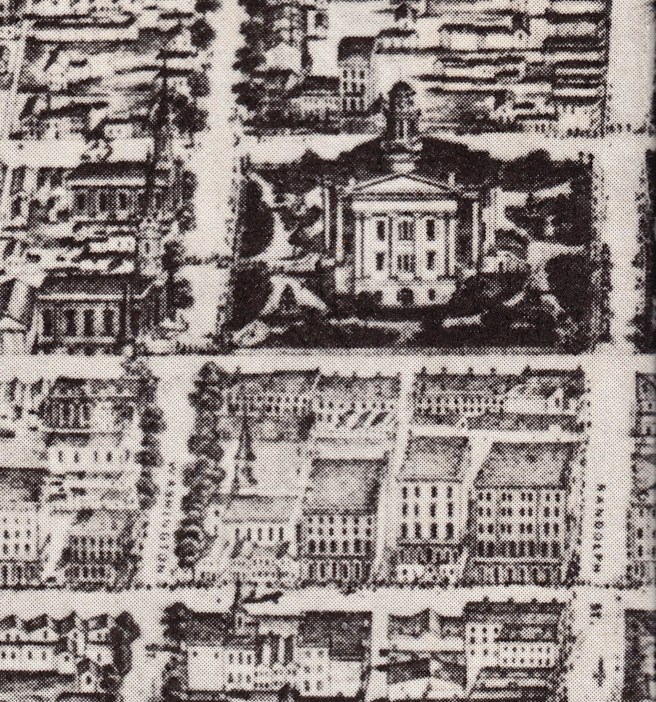
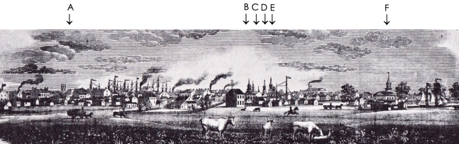
Lining the southern edge of the Courthouse Square, along Washington Street, were the city’s major churches that were some of Chicago’s best-designed buildings at the time (most, if not all of these are believed to have been designed by Van Osdel). Anchoring “Church Row” was the 163’ tall steeple of the First Presbyterian Church that Van Osdel had designed in 1847, the tallest structure in the city. By the end of 1847, the steeples of Chicago’s new churches had finally drawn even with the skyscraping masts of the ships that were tied up to the wharves along the river.
“Chicago may be emphatically pronounced the city of churches… To a traveler viewing it from a distance it presents the appearance of a congregation of spires.”
The east-west axis of Chicago, however, was as short-lived as the importance of the canal. By 1853, the $1.6 million canal loan had been repaid to its creditors, represented by Barings and Ogden, and the operation of the canal and its tolls were finally turned over to the state. Charles Butler had sold his lots for a handsome profit, and Ogden had benefited from his construction contracts as well as from his real estate agent fees. However, the return of the canal operations to state control in 1853 was anticlimactic and greeted with little celebration. The canal suffered from many problems, not the least of which was an inconsistent supply of water due to the cheaper, “shallow-cut” plan. More importantly, however, by this date the young canal was quickly becoming obsolete because the real reason for the completion of the canal had not been to improve regional transportation, but to realize a quick return from land speculation to repay the original holders of the canal bonds as well as to profit from construction contracts. Those who had profited most from the construction of the canal would be responsible for abandoning the canal in favor of an idea whose profit potential was far greater than that of the canal, the railroad, for money was to be made in the mid-nineteenth century not in the operation of transportation systems, but in their construction and in the corresponding giveaways of Tribal lands by the Federal government used to finance them. And of course, the biggest railroad would be the transcontinetal railroad and that would determine many fortunes, including Chicago’s.
Ogden was not one to waste time. Only six weeks after the Grand Opening of the canal, he had a work crew preparing the land at the corner of Kinzie and Halsted to lay the first rail in Chicago’s (the Northern) transcontinental railroad to the Pacific. It would be completed some twenty-one years later.
FURTHER READING
Andreas, Alfred T. History of Chicago. 3 vols. Chicago, 1884-1886. Reprint, New York: Arno Press, 1975.
Pierce, Bessie Louis. A History of Chicago- I. New York: Knopf, 1940.
(If you have any questions or suggestions, please feel free to eMail me at: thearchitectureprofessor@gmail.com)
