
Newberry & Dole’s success in the fall of 1839 was no small achievement, for at the time there was no bridge spanning the Main Branch of the river that wagons coming from the south or west could cross to gain easy access to their warehouse. Sectional jealousies between the North and South Divisions had boiled into open warfare earlier that year that resulted in the demolition of the Dearborn Street drawbridge. As Fort Dearborn had been erected on the south side of the river, it had been on the river’s south bank that the majority of businesses and residents had initially located simply for the sense of security that the fort provided, thus establishing the dominance of the south side of the river as the city’s business district. This location was reinforced by the fact that wagons bringing produce from Indiana also came up from the south and east. The impediment of having to cross the main branch of the river naturally had stopped any farther expansion into the North Division, which had simply reinforced the primacy of the South Division, but in truth, Chicago’s maritime businesses were so desperate for dock space because of the total inability to dock along the lakefront (due to the shallow depth of the lake, its current and fickle waves, and that “pesky” 1836 Canal Commissioner declaration that the lakefront was not to be built upon), that wharves and warehouses were simply jammed onto both banks of all three branches of the river. Thus, the city’s major urban dilemma resulted: while the river and its businesses were the primary reason for the initial existence of Chicago, in order to take maximum advantage of the limited wharfing space along the river, businesses were forced to locate on both sides of the river. These businessmen, more often than not, needed to cross the river to communicate with those on the opposite bank, having to originally rely on a ferry to cross to the other side. The first bridges constructed over the river made the crossing, especially for those riding or driving a horse, a much less cumbersome proposition, but the river was a commercial maritime thoroughfare, so any bridge over the Chicago River had to be movable, in order to permit lake schooners with tall masts to pass by.

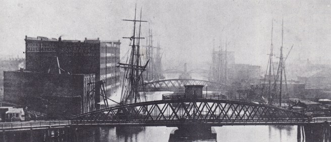
Hence, the nub of Chicago’s problem: maritime businesses needed the unimpeded navigation of the river, while the pedestrian workers of land-based businesses needed easy and efficient travel across the river. While movable bridges did allow both types of traffic to move within the city limits, when a bridge was opened to allow a ship to pass by, all land traffic was stopped and backed up for some distance. When a bridge was closed to allow the pedestrian traffic to pass, ships were forced to wait in line until the bridge was reopened. Nobody, but the municipal patronage-paid bridge tenders, seemed to be happy with the situation…
Therefore, the inconvenience of having to cross a river bridge that more often than not was opened to permit a boat to pass through, only reinforced the complete dominance of the South Division as the city’s business district (it was simply easier, and therefore, better business not to have to cross the river, period). Although the majority of the wheat came from the south and west, many of the warehouses at this time were located on the north side of the river. The Dearborn Street drawbridge was crucial to the commercial success of these businesses, of which many southside concerns were envious. In May 1839, the city approved a new floating swing bridge over the river’s south branch at Randolph Street designed and constructed by William Ogden to replace the dilapidated footbridge adjacent to the Sauganash Hotel. This permitted wagons arriving from the west to enter the South Division and join those from the ‘Wabash Country’ in northern Indiana in crossing the Dearborn bridge to the warehouses in the North Division.
In June 1839, the situation between the city’s three divisions continued to deteriorate after the Federal government had auctioned off the land in the Fort Dearborn reservation. On April 23, 1839, Secretary of War Joel Poinsett had ordered that the land within the reservation be prepared to be sold, and in June the Federal government deeded the fort’s reservation in Section 10 to the City of Chicago as the “Fort Dearborn Addition to Chicago.” This had been correspondingly platted into blocks, lots, streets, while respecting the integrity of the “public ground” that had been first designated in 1836. Meanwhile, the city’s leading figures had signed a petition asking Pres. Van Buren to postpone the sale fearing that the already depressed real estate market would only be made worse if the fort’s fifty-four acres were made available at this time. An unspoken fear, however, was even more realistic: nobody in Chicago had enough money to outbid wealthy eastern speculators (many of whom were represented by Ogden), so it seemed to the local populace that the Federal government was simply giving away some of Chicago’s choicest real estate to eastern insiders.
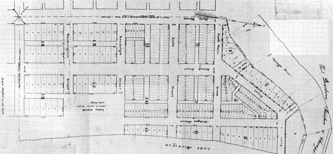
As Van Buren would soon be mounting his re-election campaign, his advisors were keenly aware (undoubtedly through reports supplied by Ogden) of the political sensitivity of this issue to Chicago’s voters. Recalling an earlier petition signed by many of the same people in 1835, requesting that the fort be sold but with the provision that some of the land be dedicated as a public park, Mayor Benjamin Wright Raymond had held out for the dedication of the half block on the west side of Michigan Avenue, bounded by Randolph on the north and Washington on the south, as Dearborn Park. The President’s advisors suggested that he go further by not only approving the Mayor’s request, but, in addition, enlarge Lake Park, to the east of Michigan Avenue, by extending it two blocks farther north from Madison to Randolph, resulting in an unbroken tract of public-owned lakefront that would extend from Randolph south to 12th Street, that was further described as: “The public ground between Randolph and Madison streets, and fronting upon Lake Michigan, is not to be occupied with buildings of any description.” The remaining Federal land north of Randolph, with the exception of the land immediately adjacent to the the river upon which had stood the fort, was platted and sold in June 1839, fetching a total sum of $106, 042. This opened up land on the south side of the river for the potential erection of warehouses that would be inherently closer to the location where farmers, who had come from the south and west, parked their prairie schooners while they sought the best deal from among the city’s grain dealers.
Then in July, Common Council voted to demolish the Dearborn Bridge. The bridge had always been in a state of disrepair since its completion due to a lack of maintenance, often being stuck in the raised position for days while repairs were attempted. Although this created havoc with traffic trying to cross the river between the South and North Divisions, boat captains viewed it as poetic justice, for the bridge’s relatively narrow opening presented an obstacle to them that was not always successfully navigated. This nuisance had become the favorite focus of invectives by sailors and pedestrians alike. These concerns played into the hands of those in the South Division, especially the owners of the new warehouses recently erected in the Old Fort Dearborn reservation, who used these complaints in their attempt to isolate the businesses in the North from the farmers coming up from the south or over the Randolph Street bridge from the west. Apparently, enough aldermen from the South and West Divisions were in agreement over the issue of the demolition of the Dearborn Bridge, that a resolution to that effect was passed in early July. Not waiting for the bridge’s proponents in the North Division to influence enough aldermen to reverse their vote and rescind the action, a mob assembled at the sentenced bridge just before daybreak the next morning and axed it to pieces.
Earlier in the year Council had, in fact, authorized a replacement for the bridge to be built at Wells Street (that would have been more in line with the fourteen blocks that Walter Newberry owned on the northside along both sides of Wells from Illinois north to Chicago Avenue) with the stipulation that most of the cost be borne by stock subscriptions from property owners in the North Division. With the Dearborn Bridge intact, however, there seemed to be no need for incurring such a financial burden during a time of such economic hardship, so nothing was done. All that changed, however, with the swift execution of the North’s only link to the South. Now the only way for the farmers to get to Newberry & Dole’s warehouse were two rope-operated ferries at State and Clark Streets. These were large enough to carry two double teams of oxen, but as Ogden lamented over the despair of northside property owners to Arthur Bronson in New York:
“The rent of every warehouse on this side would be reduced all of 1/3 if we have no bridge. Hoosier oxteams with wheat etc. wont [sic] come over the river on a ferry boat if they can avoid it.”
Ogden, along with Newberry and other northside owners, were close to their wits’ end in trying to devise a way to circumvent the majority in Council that the South and West Divisions had forged in opposition to the North. Finally, in order to get just enough Council votes to authorize the construction of a replacement bridge to the north, Ogden and Newberry donated the entire block bounded by Chicago, Cass (Wabash), Superior and Wolcott (State) Streets, (where Holy Name Cathedral stands today) to the leaders of the Catholic church in exchange for enough Catholic votes on Council to approve a new bridge. The tactic was successful for just enough votes were changed to result in a tie, that was broken by Mayor Raymond, who voted for the bridge only after securing assurances from Ogden and Newberry that they would pay for the bridge’s construction. In deference to Newberry, however, the new bridge was located at Clark Street, a block closer to his holdings. Ogden, meanwhile, made sure that the new bridge would be constructed on time and to his liking by taking the contract to build what he himself had also designed. Subsequently, he also ended up having to pay a greater proportion of its total cost because while it was to be financed by the sale of bonds at seven per cent interest, only $2000 of the bridge’s final cost of $3000 was raised, Ogden himself having subscribed for much of that by himself. Although construction began on April 18, 1840, and was completed by the end of the year, the remaining $1000 had to be absorbed by himself, who viewed the extra cost as a necessary business expense.
While Council had been fiddling over the Dearborn Street bridge issue, Chicago suffered its first conflagration. On October 27, 1839, a fire erupted on Lake Street, near to the former site of the Dearborn Street bridge. Seventeen buildings, including the Tremont House, were destroyed before the fire was stopped with the controlled explosion of an eighteenth building that was in the path of the fire. The sustained loss was estimated to have been between $60,000 and $75,000 that coming in a depression, was only compounded by the lack of any insurance on the part of most of the building owners. Nonetheless, in December, the owners of the Tremont House, James and Ira Couch, commenced building a larger Tremont House on the southeast corner of Lake and Dearborn, diagonally across Lake Street from the site of the original hotel. The second Tremont House opened to the public on May 20, 1840.
FURTHER READING:
Andreas, Alfred T. History of Chicago, 3 vols. Chicago, 1884-1886. Reprint, New York: Arno Press, 1975.
Arnold, Isaac N. “William B. Ogden: and Early Days in Chicago,” Fergus Historical Series, No, 17. Chicago: Fergus, 1882.
Ericsson, Henry L. Sixty Years a Builder: The Autobiography of Henry Ericsson. Chicago: A. Kroch, 1942.
Lutz, Thomas J., Shaping Chicago: James S. Dunham’s Crusade for the River, Michigan: In-Depth Editions, 2012.
Mayer, Harold M., and Richard C. Wade. Chicago: Growth of a Metropolis. Chicago: University of Chicago Press, 1969.
Pierce, Bessie Louis. A History of Chicago– 3 volumes. New York: Knopf. 1940.
Wille, Lois. Forever Open, Clear, and Free; The Struggle For Chicago’s Lakefront. Chicago: Regnery, 1972.
______________. Biographical Sketches of the Leading Men of Chicago. Chicago: Wilson & St. Clair, 1868.
(If you have any questions or suggestions, please feel free to eMail me at: thearchitectureprofessor@gmail.com)
