2.5. THE CENTRAL RAILROAD: THE ST. LOUIS CUT-OFF

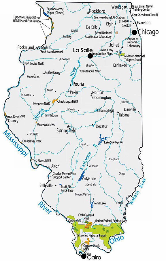
Meanwhile, within a year of Bucklin’s having been given his task to cost out the canal options in 1831, the first proposal for a railroad in Illinois surfaced in the Illinois legislature.  However, the proposal was not an alternative to the canal, but one that aimed at strengthening the chances of the canal’s success. Illinois’ Lieutenant Governor A. M. Jenkins foreshadowed the coming battle between St. Louis and the yet-to-be chartered town of Chicago by proposing what was to become referred to as the “St. Louis Cut-off:” a “Central” railroad from the end of the canal at La Salle straight south through the center of the state to the junction of the Mississippi and Ohio Rivers.  St. Louis’ location at the junction of the Mississippi, Missouri, and Illinois Rivers had naturally allowed it to become the economic capital in the trans-Mississippi Valley as it was much less expensive to travel and ship goods to the Atlantic seaboard via the Mississippi downriver to New Orleans than it was either overland or via the Ohio River upriver to Pittsburgh and then overland to the Atlantic.  Therefore, the majority of Illinois’ early settlement had economically gravitated toward St. Louis.  St. Louis’ economic position would be vastly enhanced with the construction of the Illinois & Michigan Canal, for the Illinois River joined the Mississippi at Alton, IL, just upriver from St. Louis.  Great Lakes traffic via the Illinois River, therefore, destined either for the West would have to pass St. Louis on its way to the Missouri River, or for the South would have to pass St. Louis on its way to Memphis or New Orleans.  Hence, St. Louis’ political leaders had all thrown their support behind the Federal improvements of the Chicago canal.

The first proposed route for the Central Railroad started at the end of the planned Illinois & Michigan Canal at La Salle (top dot) and ended at the confluence of the Ohio and Mississippi Rivers (lower dot). (Online)

Thus, the proposed canal presented a political problem for those politicians who wanted to unify the new state, for the presence of St. Louis tended to divide Illinois into the southern half that naturally gravitated toward St. Louis (and was pro-slavery), and the emerging northern half that in the western portion centered around Galena, that although being larger than St. Louis, was still dependent on St. Louis’ connections with New Orleans as it shipped its lead down the Mississippi.

The politicians whose goal was to build Chicago and its canal as a political counterbalance to St. Louis in the northeastern portion of Illinois, therefore, eventually had to trick St. Louis into supporting the canal, and then stab its older competitor in the back by building an alternative means of transporting goods in the southern half of the state.  Water in a canal has no current, however, and once having secured St. Louis’ support in gaining the Federal aid, Illinois’ leaders now began their campaign to bypass the river city’s central position in the region by diverting traffic away from St. Louis with the proposed Central Railroad, and thereby reroute the state’s inland traffic either north through the Chicago canal or south via the proposed railroad to Cairo (at the junction of the Ohio and Mississippi Rivers).  Thus, the Central Railroad was planned to gain more Downstate legislative support for the canal scheme, that up until this time had been viewed as one that would benefit only the northern half of the state.  Lacking initial support, however, the Central Railroad proposal would lay dormant for three years, until a political compromise would finally break the political logjam over the construction of the canal.

FURTHER READING:

Andreas, Alfred T. History of Chicago, 3 vols. Chicago, 1884-1886. Reprint, New York: Arno Press, 1975.

Fergus, Robert, Fergus’ Historical Series, No. 18: Chicago River – And – Harbor Convention, Chicago, 1882.

(If you have any questions or suggestions, please feel free to eMail me at: thearchitectureprofessor@gmail.com)

2.4. THE CINCINNATI & CHARLESTON RAILROAD

The feasibility of constructing a railroad to span such distances was being proven as the longest route in the world at this moment was about to be completed in South Carolina by Horatio Allen.  On October 3, 1833, the South Carolina Canal & Railroad made its first run along its 136-mile-long route between Charleston and Hamburg, on the Savannah River.  By then, the company’s management had already begun exploring the possibilities of extending their route to the Ohio River to extend Charleston’s inland market in an attempt to make Charleston the major Atlantic port.  These events in Charleston did not go unnoticed in the West’s largest city, Cincinnati.  By this time the State of Ohio had embarked on an aggressive canal building campaign ignited by the success of the Erie Canal.  In 1832 it had completed the Ohio & Erie Canal that linked Cleveland on Lake Erie to the Ohio River at Portsmouth, OH, a 308-mille route that was nearly as long as the Erie Canal’s.  In 1829, construction had started on the second phase of the state’s canal system, the Miami & Erie Canal, eventually completed in 1845 along a route that would link Cincinnati on the Ohio River with Lake Erie at Toledo.  For Cincinnati, already enjoying the commercial trade along the Ohio River as well as from inland Kentucky communities along the Licking River that emptied into the Ohio across from it, the new canal promised more trade from inland Ohio as well as from Lake Erie that would only enhance the city’s premiere position in the West in its competition with neighboring Louisville (in 1830, the populations of these cities were as follows: Cincinnati-24,831, Louisville-10,341, Galena-10,000+, St. Louis-5,882, Chicago-40).

Ohio’s two central canals. (Online)

But the railroad was “in the air” and Ebenezer Thomas, the editor of the Cincinnati Daily Evening Post, had been promoting the idea of a railroad from Cincinnati to Charleston to open up new markets in the southeast as well as to give the city a direct outlet to the Atlantic.  Thomas had moved to Cincinnati in 1829 from Charleston, where he had first been exposed to Stephen Elliott’s proposal to build a line to the Mississippi.  Thomas’ proposal was adopted by one of Cincinnati’s patricians, Dr. Daniel Drake, responsible for the founding in 1819 of Medical College of Ohio, the first medical School west of the Appalachians, among his many other accomplishments.  At a meeting in Cincinnati on August 10, 1835, Drake proposed the idea of building a railroad from the Kentucky bank of the Ohio River, across from Cincinnati to connect with the SCC&RR as the final link to Charleston.  Drake clearly stated the economic and political advantages of joining the NorthWest to the South that were isolated from each other by the Appalachian Mountains to the south of the Ohio River by breaking through at the Cumberland Gap: “The north and the south would, in fact, shake hands with each other, yield up their social and political hostility, pledge themselves to common national interests, and part as friends and brethren.”  The Cincinnati group followed up with the appointment of a Standing Committee of Correspondence, charged with eliciting support for the proposal throughout the effected region.  For publicity reasons, the Committee was headed by the NorthWest’s war hero, William Henry Harrison, who had led American troops in the defeat of the British and their Native allies at the 1813 Battle of Moraviantown, and thereby, secured the NorthWest from any further British incursions during the War of 1812, but the workhorse of the group was, of course, Drake.

Drake’s equivalent in Charleston was former U.S. Senator Robert Young Hayne, one of Charleston’s ablest politicians who at this time was the city’s mayor.  The city’s Chamber of Commerce met on Oct. 22, 1835, to endorse the Cincinnati proposal, after which Hayne took control of the city’s involvement:

“We can almost perceive the finger of heaven pointing to the barriers which have long separated them [West and South], and reverently think we HEAR THE VOICE OF GOD, [capitals are original] speaking through his works, commanding us to remove those obstacles, and encouraging our exertions, by the promise of abundant blessings, with which a wise and beneficent Providence, seldom fails to regard the faithful efforts of his children.”

Following Cincinnati’s lead, the Charleston group also appointed a standing committee that undertook two important processes.  First, they pushed for the chartering of the Cincinnati & Charleston Railroad in the states through which the route would pass: South Carolina, North Carolina, Tennessee, and Kentucky, and by March 1836 all four states had done so.  The irony was that Ohio, the state that probably stood to gain the most through the continued growth of Cincinnati’s economy, refused to do so, claiming the potential damage that such a railroad might have on the state’s other internal improvements.  Advocates of Cincinnati’s competing neighbor, Louisville, however, had also made Kentucky’s legislature hold out for the concession of a branch of the road to end at Louisville, which the railroad’s supporters not only agreed to, but to assure continued support from the Blue Grass state, wisely revised the company’s name to the Louisville, Cincinnati & Charleston Railroad.  Second, the Committee arranged for surveys for the route, paid for by a $10,000 appropriation by the South Carolina legislature, to be conducted by Capt. William G. Williams and Col. James Gadsden, South Carolina’s chief engineer.

Map showing the proposed route of the Louisville, Cincinnati & Charleston Rail Road. (Grant, The LC&C RR)

A convention, the Great Southern Railroad Convention was held in Knoxville, TN, midway between the two planned termini on July 4-8, 1836, to discuss the next steps, which was attended by 380 delegates, the largest railroad convention ever to gather in the antebellum South.  Hayne was unanimously elected to be the company’s president, while he also joined Drake among those who sat on the all-important Committee of Forty-Five that hammered out the important details.  Considering the potential conflicts, the event ended quite harmonious with the exertion that all involved should move forward with the greatest of speed. Pres. Hayne at once began the campaign to secure the $4 million in stock subscriptions needed to incorporate the company.  Meanwhile, Cincinnati looked forward to the completion the road, anticipating even greater economic results for its businesses and civic status…

FURTHER READING:

Grant, H. Roger. The Louisville, Cincinnati, & Charleston Rail Road. Bloomington: Indiana University Press, 2014.

(If you have any questions or suggestions, please feel free to eMail me at: thearchitectureprofessor@gmail.com)

2.3. EARLY PROPOSALS FOR A TRANSCONTINENTAL RAILROAD

Map showing the 1828 proposed route of the Louisville, Cincinnati & Charleston Rail Road. (Grant, The LC&C RR)

Although John Stevens in 1823 had been the first to project a system of interstate railroads that connected the Atlantic seaboard with the trans-Appalachian hinterlands in order to maintain Philadelphia’s national economic hegemony, it did not take long for business leaders from the other Atlantic ports, especially once the impact of the Erie Canal had been fully digested, to follow-up with their own proposals.  Following the chartering of the South Carolina Canal & Railroad, Stephen Elliott, the president of Charleston’s South Carolina State Bank had proposed in 1828 that its route be extended to the confluence of the Ohio and Mississippi Rivers (there would not be a chartered settlement at this location until 1836 that would then be named Cairo, IL) in an attempt to divert from New Orleans the agricultural products beginning to come from the burgeoning West in order to make Charleston the major Atlantic port.   In the following year, 1829, New Yorker William C. Redfield also made a proposal to build an interstate railroad from the Atlantic to the Mississippi River in a pamphlet he later titled Sketch of the Geographical Rout [sicof a Great Railway by Which It Is Proposed to Connect the Canals and navigable Waters of New-York, Pennsylvania, Ohio, Indiana, Illinois, Michigan, Missouri, and the Adjacent States and Territories:   

“A Great Railway by which it is proposed to connect the canals and navigable waters of New York, Pennsylvania, Ohio, Indiana, Illinois, Michigan, Missouri, and the adjacent States and Territories, opening thereby a Free Communication between the Atlantic States and the Great Valleys of the Mississippi…  This great plateau will, indeed, some day be intersected by thousands of railroad communications, and so rapid will be the increase of its population and resources that many persons now living will probably see most or all of this accomplished.”

Redfield’s planned route from New York City went first to Buffalo (to link with the Great Lakes) and then hugged the southern shore of Lake Erie until it broke straight west along the 42nd parallel through Northern Indiana to the mouth of the Calumet River at the southern-most tip of Lake Michigan.  From there it logically headed west through Illinois to Fort Armstrong on Rock Island, a location that suggested bridging the Mississippi because the span to do so at this point was one of the shorter distances along the length of the river due to the position of the island in the river. 

Location of Fort Armstrong on Rock Island. Redfield’s proposed route ran from New York City, to Buffalo, around the south edge of Lake Erie, straight to the southern tip of Lake Michigan at the Calumet River and then on to Rock Island. There was no Chicago in 1829. (Online)

Interestingly, the Federal government at this time had just begun to use the loophole it had written into the 1804 Treaty of St. Louis by selling “its Land” north of the Indian Boundary line to private owners.  This opened the way to remove the remaining Natives from the land east of the Mississippi in northern Illinois and southern Wisconsin.  Therefore, Rock Island, located at the center of approximately 1,200 miles of navigable waterways throughout the growing NorthWest, seemed to be an appropriate termination for Redfield’s Great Railroad. When Redfield had surveyed the route in 1829, there was no Chicago to the north of the Calumet River to warp his westward route inefficiently to the north. (Inspired by Redfield’s proposal and Jervis’ completion of the Mohawk & Hudson in 1831, a series of ten railroads would be constructed between 1831 and 1842 that linked Albany to Buffalo, essentially paralleling the Erie Canal, that would eventually be merged in 1853 into one company, the New York Central Railroad.)

Map of the Railroads that Formed the “Central” Railroad System in New York State.  (Men and Iron: A History of the New York Central)

In February 6, 1832, the Ann Arbor (MI) Emigrant published an article (probably written by its publisher, Judge S. W. Dexter) in which the author proposed to extend Redfield’s interstate route (including Redfield’s bypassing the mouth of the Chicago River) into a full-fledged transcontinental railroad to the Pacific Coast (that would be the actual route used by the Union Pacific some thirty years in the future):

“The distance between New York and Oregon is about three thousand miles.  From New York we would pursue the most convenient route to the vicinity of Lake Erie, thence along the south shore of this lake and of Lake Michigan, cross the Mississippi between forty-one and forty-two of the north latitude, cross the Missouri about the mouth of the Platte, and thence to the Rocky Mountains, near the source of the last named river, thence to Oregon, by the valley of the south branch of that stream, called the southern branch of Lewis’ River.”

This was written three months before Capt. Bonneville struck out from Independence, MO, hoping to blaze what would becalled the Oregon Trail. Another claimant to being the first to propose a transcontinental railroad was Dr. Hartwell Carver of Rochester, NY, who submitted a similar proposal to Congress for such a road later in 1832.

FURTHER READING:

Anderson, Frederick K., Joined By a River: Quad Cities, Rock Island, 1982

Harlow, Alvin F. The Road of the Century. New York: Creative Age Press, 1947.

Williams, John Hoyt. A Great and Shining Road-The Epic Story of the Transcontinental Railroad. Lincoln: University of Nebraska Press, 1989.

(If you have any questions or suggestions, please feel free to eMail me at: thearchitectureprofessor@gmail.com)